
Mount Wilson (California) facts for kids
Quick facts for kids Mount Wilson |
|
|---|---|

The northern slope of Mount Wilson, atop which sits an antenna farm near its summit, as seen from Angeles Crest Highway
|
|
| Highest point | |
| Elevation | 5,713 ft (1,741 m) NAVD 88 |
| Prominence | 150 ft (50 m) |
| Geography | |

Mount Wilson
Location in the Los Angeles metropolitan area
|
|
| Parent range | San Gabriel Mountains |
| Topo map | USGS Mount Wilson |
| Climbing | |
| Easiest route | Drive |
Mount Wilson is a mountain peak in the San Gabriel Mountains in Los Angeles County, California. It is part of the San Gabriel Mountains National Monument and Angeles National Forest. Even though it's not the tallest mountain around, you can easily spot it because of the many antennas near its top.
Mount Wilson is famous for the Mount Wilson Observatory. This is an important place for studying space. It has large telescopes, including ones that are 60-inch (1,524 mm) and 100-inch (2,540 mm) wide. There are also tall solar towers that are 60-foot (18.3 m) and 150-foot (45.7 m) high. These are used to study the Sun. The CHARA Array is also here. It helps scientists learn more about stars.
The top of Mount Wilson is about 5,710 feet (1,740 m) high. Sometimes, it even snows there, which can stop the telescopes from working. From the summit, you can see amazing views across the Los Angeles Basin, Orange County, and the Inland Empire. You can also see all the way to the Pacific Ocean. On clear days, you might even spot Santa Catalina Island, which is about 65 mi (105 km) away. Other Channel Islands can be seen too, like San Clemente Island and Santa Cruz Island.
Mount Wilson is also very important for broadcasting. Many radio and television stations for the Greater Los Angeles Area have their antennas here.
Contents
Weather at Mount Wilson
| Climate data for Mount Wilson, California, 1991-2020 normals | |||||||||||||
|---|---|---|---|---|---|---|---|---|---|---|---|---|---|
| Month | Jan | Feb | Mar | Apr | May | Jun | Jul | Aug | Sep | Oct | Nov | Dec | Year |
| Record high °F (°C) | 77 (25) |
80 (27) |
83 (28) |
86 (30) |
92 (33) |
101 (38) |
102 (39) |
101 (38) |
98 (37) |
94 (34) |
84 (29) |
78 (26) |
102 (39) |
| Mean daily maximum °F (°C) | 53.4 (11.9) |
53.8 (12.1) |
55.6 (13.1) |
61.1 (16.2) |
68.6 (20.3) |
77.5 (25.3) |
83.5 (28.6) |
84.1 (28.9) |
79.9 (26.6) |
70.6 (21.4) |
61.9 (16.6) |
54.6 (12.6) |
67.1 (19.5) |
| Daily mean °F (°C) | 44.8 (7.1) |
44.2 (6.8) |
46.8 (8.2) |
51.3 (10.7) |
58.2 (14.6) |
66.7 (19.3) |
73.0 (22.8) |
73.5 (23.1) |
68.0 (20.0) |
60.3 (15.7) |
51.9 (11.1) |
45.0 (7.2) |
57.0 (13.9) |
| Mean daily minimum °F (°C) | 36.1 (2.3) |
36.6 (2.6) |
37.8 (3.2) |
41.7 (5.4) |
48.2 (9.0) |
57.5 (14.2) |
64.2 (17.9) |
63.9 (17.7) |
59.0 (15.0) |
51.3 (10.7) |
43.4 (6.3) |
37.4 (3.0) |
48.4 (9.1) |
| Record low °F (°C) | 9 (−13) |
11 (−12) |
14 (−10) |
18 (−8) |
22 (−6) |
29 (−2) |
38 (3) |
37 (3) |
34 (1) |
18 (−8) |
15 (−9) |
10 (−12) |
9 (−13) |
| Average precipitation inches (mm) | 7.73 (196) |
8.26 (210) |
5.63 (143) |
2.05 (52) |
1.05 (27) |
0.21 (5.3) |
0.21 (5.3) |
0.01 (0.25) |
0.32 (8.1) |
1.31 (33) |
3.48 (88) |
4.46 (113) |
34.72 (880.95) |
| Average snowfall inches (cm) | 3.6 (9.1) |
2.4 (6.1) |
3.0 (7.6) |
1.4 (3.6) |
0.1 (0.25) |
0.0 (0.0) |
0.0 (0.0) |
0.0 (0.0) |
0.0 (0.0) |
0.0 (0.0) |
0.6 (1.5) |
1.7 (4.3) |
12.8 (32.45) |
| Average precipitation days (≥ 0.01 in) | 6.7 | 8.6 | 6.8 | 4.4 | 2.5 | 1.0 | 1.0 | 0.4 | 1.0 | 2.9 | 4.2 | 6.8 | 46.3 |
| Source: NOAA | |||||||||||||
Mount Wilson has a varied climate. Summers are warm, while winters are cool. It gets a good amount of rain, especially in winter. Snowfall can happen, sometimes enough to affect activities on the mountain.
History of Mount Wilson
.jpg)

The first people to live in the San Gabriel Mountains were likely the Tongva people. They lived in the valleys below. You can still find signs of them, like grinding spots on rocks where they prepared food.
Early Explorers and Trails
The first recorded trip up the mountain was by Benjamin Davis Wilson around 1852. He was looking for good wood for his winery. He didn't find the wood he wanted, but he built a trail. This trail followed an old Native American path and became known as the Mount Wilson Trail.
Wilson also built a small cabin along the trail called "Halfway House." Hiking to the summit became a popular activity for people nearby. They would light signal fires at the top to let others know they arrived safely. Later, this trail led to the creation of the Mount Wilson Toll Road.
Mount Wilson Observatory

Mount Wilson is famous for its important role in astronomy.
Early Astronomy Efforts
In 1889, Professor William Henry Pickering from Harvard University tried to set up telescopes on Mount Wilson. But the students who were supposed to use them often reported bad weather and went to town instead! So, this small observatory was eventually left behind.
In 1891, a man named Thaddeus S. C. Lowe planned to build a scenic mountain railway to the top of Mount Wilson. Around the same time, a new road called "The New Mount Wilson Trail" was built. It cost 25 cents for hikers to use it.
In 1903, George Ellery Hale visited Mount Wilson. He was very impressed by how clear the sky was, which made it perfect for an observatory. In 1904, the Mount Wilson Solar Observatory was started.
Building the Great Telescopes
In 1905, the Carnegie Institution for Science rented 40 acres (160,000 m2) of land for 99 years to build telescopes. Construction began, and in 1908, a 60 in (1,500 mm) telescope was finished. In 1910, the 150-foot (46 m) Solar Tower was built to study the Sun.
In 1917, the 100 in (2,500 mm) Hooker Telescope was completed. For many years, it was the largest telescope in the world! It remained the biggest until the 200 in (5,100 mm) Hale Telescope opened at Palomar Observatory in 1948.
Discoveries at Mount Wilson
In 1919, a famous astronomer named Edwin Hubble came to Mount Wilson. In the 1920s, he used the Hooker Telescope to make amazing discoveries. He proved that many fuzzy objects in the sky were actually other galaxies far beyond our own Milky Way galaxy. He also showed that the universe is not still, but is actually expanding! This idea is a key part of the Big Bang theory, which explains how the universe began.
In 1926, another scientist, Albert Abraham Michelson, used Mount Wilson to make a very accurate measurement of the speed of light. He measured how long it took for light to travel between Mount Wilson and Mount San Antonio, which was 22 mi (35 km) away.
Modern Astronomy at Mount Wilson
In 1984, the Carnegie Institution for Science started to reduce its work at Mount Wilson. But in 1986, a group called the Mt. Wilson Institute was formed. They worked to reopen the observatories, and by 2000, all the telescopes were working again.
In 1996, construction began for six new telescopes. These are part of the Center for High Angular Resolution Astronomy at Georgia State University. This was the largest optical interferometer at the time. It started working in 2001 and helps scientists study stars in great detail.
Broadcasting from Mount Wilson

Mount Wilson is a very important site for broadcasting radio and television.
Television Stations
The first television antenna on Mount Wilson was put up in 1947 for station KTLA channel 5. Since then, many other TV stations have built their antennas here. This mountain is a central hub for television signals across the Los Angeles metropolitan area.
Some of the television stations that broadcast from Mount Wilson include:
- KCBS (Channel 2, CBS)
- KNBC (Channel 4, NBC)
- KTLA (Channel 5, The CW)
- KABC (Channel 7, ABC)
- KCAL (Channel 9, Independent)
- KTTV (Channel 11, Fox)
- KCOP (Channel 13, MyNetworkTV)
- KCET (Channel 28, PBS)
- KMEX (Channel 34, Univision)
- KOCE (Channel 50, PBS)
- KLCS (Channel 58, PBS)
The tallest antenna on Mount Wilson is for KCBS-TV. It stands at a height of 972 ft (296 m).
Radio Stations
Many FM radio stations also broadcast from Mount Wilson. These stations send their signals across the Los Angeles area.
Some of the FM radio stations broadcasting from Mount Wilson are:
- KPCC-FM 89.3
- KPFK-FM 90.7
- KUSC-FM 91.5
- KRRL-FM 92.3
- KCBS-FM 93.1
- KLLI-FM 93.9
- KTWV 94.7
- KLOS-FM 95.5
- KNX-FM 97.1
- KKLA-FM 99.5
- KKLQ-FM 100.3
- KRTH-FM 101.1
- KSCA-FM 101.9
- KIIS-FM 102.7
- KOST-FM 103.5
- KBIG-FM 104.3
- KKGO-FM 105.1
- KPWR-FM 105.9
- KLVE-FM 107.5
Images for kids
-
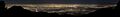
A wide view of Los Angeles from Mount Wilson.
