
Channel Islands (California) facts for kids
 |
|
 |
|
| Geography | |
|---|---|
| Location | Pacific Ocean |
| Total islands | 8 |
| Area | 350.89 sq mi (908.8 km2) |
| Highest elevation | 2,429 ft (740.4 m) |
| Highest point | Devils Peak, Santa Cruz Island |
| Administration | |
|
United States
|
|
| State | California |
| Counties | |
| Largest settlement | Avalon (pop. 3,728) |
| Demographics | |
| Population | 4,603 (2010) |


The Channel Islands are a group of eight islands. They are located in the Pacific Ocean off the coast of California. These islands help form the Santa Barbara Channel, which is the water between the islands and the California mainland. The four northern islands are part of one geologic province (a large land area with similar rock types). The four southern islands are part of another.
Five of these islands are protected within the Channel Islands National Park. The waters around these islands are part of the Channel Islands National Marine Sanctuary. This sanctuary helps protect the ocean life.
Long ago, Native American groups like the Chumash and Tongva lived on these islands. Later, Spanish people came and used the islands for fishing and farming. The Channel Islands are home to many unique plants and animals. Some of these species are found nowhere else in the world.
Two islands, San Clemente Island and San Nicolas Island, are used by the US Navy. They use them for training, testing weapons, and for defense.
Contents
Exploring the Channel Islands
The eight Channel Islands are spread across three California counties. Four islands are in Santa Barbara County, two in Ventura County, and two in Los Angeles County. The islands are divided into two main groups: the northern and southern Channel Islands. The four northern islands were once connected as one large landmass called Santa Rosae.
The islands stretch about 160 miles (257 km) from north to south. Their total land area is about 346 square miles (896 square kilometers).
Five of the islands are part of the Channel Islands National Park. These are San Miguel, Santa Rosa, Santa Cruz, Anacapa, and Santa Barbara Island. The Channel Islands National Marine Sanctuary protects the ocean waters around these five islands.
Santa Catalina Island is the only island with a large town. This town is called Avalon. There is also a smaller community called Two Harbors. The University of Southern California has a marine research lab in Two Harbors.
The main visitor center for the Channel Islands National Park is in Ventura Harbor. Many people visit the islands each year, especially in summer. You can reach the islands by boat or plane. Camping is allowed on some islands. Popular activities include whale watching, hiking, snorkeling, kayaking, and camping.
Sometimes, natural oil seeps occur in the Santa Barbara Channel. Small pieces of tar can be found on the beaches. Long ago, Native Americans used this natural tar for many things. They used it for roofing, waterproofing, and even for special ceremonies.
The lower parts of the Channel Islands almost never get frost. It rarely snows, and then only on the highest mountain peaks.
Island Facts
Here are the eight Channel Islands of California. They are located off the west coast of North America.
| Island | Indigenous Name and Meaning |
Area mi2 |
Area km2 |
Population Census 2000 |
County | Highest peak feet (m) |
|---|---|---|---|---|---|---|
| Northern Channel Islands | ||||||
| Anacapa | Anyapakh (deception or mirage) |
1.14 | 2.95 | 3 | Ventura | Summit Peak, 930 (283) |
| San Miguel | Tuqan (unknown meaning) |
14.57 | 37.74 | – | Santa Barbara | San Miguel Hill, 831 (253) |
| Santa Cruz | Limuw (place of the sea) |
96.51 | 249.95 | 2 | Santa Barbara | Devils Peak, 2429 (740) |
| Santa Rosa | Wi'ma (redwood driftwood) |
83.12 | 215.27 | 2 | Santa Barbara | Soledad Peak, 1589 (484) |
| Southern Channel Islands | ||||||
| San Clemente | Kinkipar | 56.81 | 147.13 | 300† | Los Angeles | Vista Point, 1965 (599) |
| San Nicolas | Haraasnga | 22.75 | 58.93 | 200† | Ventura | Jackson Hill, 907 (276) |
| Santa Barbara | Tchunashngna | 1.02 | 2.63 | – | Santa Barbara | Signal Hill, 634 (193) |
| Santa Catalina | Pimuu'nga | 74.98 | 194.19 | 4,096 | Los Angeles | Mount Orizaba, 2,123 (648) |
| Channel Islands | 350.89 | 908.79 | 4,603 | Devils Peak, 2,429 (740) | ||
| †Navy installations, itinerant military and civilian population |
||||||
How the Islands Formed
The Channel Islands are mostly made of sedimentary rock. This rock sits on top of a deep layer of volcanic rock. This volcanic rock formed from undersea eruptions about 15 to 19 million years ago.
The islands are part of the Pacific Plate, a huge section of the Earth's crust. This plate is slowly moving. About 5 million years ago, the Pacific Plate collided with the North American Plate. This collision caused the Channel Islands to be pushed up above the ocean. This process of folding and faulting continues even today.
During past ice ages, sea levels were much lower. This meant that more land was exposed. Several of the islands were actually connected into one big island. When sea levels rose, less land was visible. You can still see old shorelines high up on the islands' slopes.
Island History
The Channel Islands have been separated from the California mainland for a very long time. This means they show the earliest signs of humans using boats in the Americas. People lived on the northern Channel Islands at least 13,000 years ago.
The remains of a person called the Arlington Springs Man were found on Santa Rosa Island in 1960. These remains are about 13,000 years old. The Tuqan Man was found on San Miguel Island in 2005. His remains are about 10,000 years old.
These old sites on the islands give us important clues. They show how humans lived and interacted with the island's plants and animals. The Anacapa Island Archeological District is a special historic area. It was added to the National Register of Historic Places in 1979.
Native Peoples

Historically, the northern islands were home to the island Chumash. The southern islands were home to the Tongva.

The oldest known Chumash village site is on Santa Rosa Island. It dates back about 7,500 years. The Chumash lived in large villages with many residents. Their villages had houses, sweat lodges, and places for food storage. The Chumash were very organized in how they built and managed their communities.
The Tongva people used many things from the ocean, like shells. They made shell beads, which were important for their economy. They traded these beads for food and other goods from the mainland.
Around 2,500 years ago, new tools and fishing methods appeared. People started using circular shell fishhooks more often. Mortars and pestles (tools for grinding) were made on San Miguel Island and traded with the mainland. Old sites on San Miguel Island show some of the earliest known fishing hooks.
A new type of boat appeared on the islands about 1,500 years ago. The Chumash called it a tomol, and the Tongva called it a te'aats. These boats became very important to their cultures. They were well-made and could carry many families across the islands. The boats were made from tule plants, which made them float well.
Modern History
The Nicoleño
The Nicoleño were a Native American group who lived on San Nicolas Island. Their population was greatly reduced by sea otter hunters in the early 1800s. The last known member of this group was a woman named Juana Maria. She was born before 1811 and passed away in 1853.
Juana Maria, also known as the "Lone Woman of San Nicolas Island," lived alone on the island from 1835 until 1853. Men found her living in a hut made of whalebones and brush. She became sick after eating too much green corn and fresh fruit. She died about seven weeks after being brought to the mainland. Before she died, she was given the name Juana Maria.
In the early 1800s, Aleut hunters visited the islands to hunt otters. They sometimes had conflicts with the native Chumash people. These interactions were described in the book Island of the Blue Dolphins.
The Chumash and Tongva people were moved from the islands in the early 1800s. They were taken to Spanish missions on the mainland. For about a century, the Channel Islands were mainly used for ranching and fishing. Whalers also used some islands in the 1930s to hunt whales. This greatly affected the island's wildlife. For example, sea otters and bald eagles disappeared from the islands.
Because there were fewer otters, their prey, the black abalone, grew in number. This made the Channel Islands an important stop for Chinese-American fishermen in the 1850s. They harvested abalone and sent them to Hong Kong.
Today, most of the Channel Islands are managed by government agencies or conservation groups. This has helped the island ecosystems recover. For example, the bald eagle population is now growing again. The Catalina Island Fox has also recovered. Its population grew from only 100 foxes to over 1,500 by 2018.

Military Use
The United States Navy controls San Nicolas Island and San Clemente Island. They also have bases on other islands. During World War II, all the Channel Islands were under military control. Even Santa Catalina Island, which had civilians, needed special permits for travel.
San Miguel Island was used for bombing practice. Santa Barbara Island was an early warning outpost. San Clemente Island was used to train the Navy's first amphibious (land and water) forces.
Since 1957, San Nicolas Island has been used to launch research rockets. Santa Rosa Island was a base for the Air Force in the 1950s. They used large radars there to detect aircraft. The islands are still used today for training by the US Navy SEALs.
Island Wildlife
The Channel Islands are part of a very rich ocean ecosystem. Many unique plants and animals live only on these islands. These include the Channel Islands spotted skunk and a special type of Torrey pine tree.

-
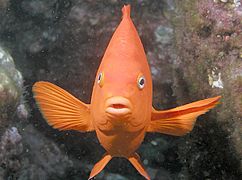
Garibaldi, Catalina Island
-
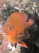
Juvenile Garibaldi, Catalina Island
-
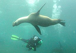
Diver and juvenile sea lion, Anacapa Island
-
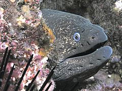
California moray eel
-
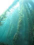
Kelp forest and sardines
-
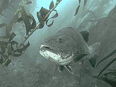
Giant black sea bass, San Clemente Island
-
Sea fan, Anacapa Island
-
Hermissenda crassicornis, San Clemente Island
-
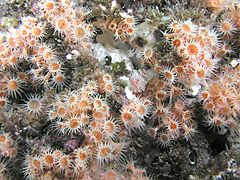
Anemones, Catalina Island
-
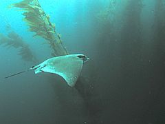
Bat ray in kelp forest, San Clemente Island
-
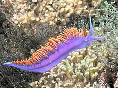
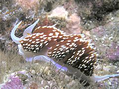
Spanish shawl nudibranch
-
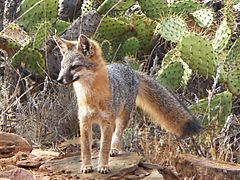
A Catalina Island Fox. Their population dwindled to 100 individuals before rebounding with the help from scientists from the USC Wrigley Institute for Environmental Studies.


Plants
The plants on the Channel Islands include unique types of pine and oak trees. There is also the island tree mallow. Santa Rosa Island has two groups of a rare Torrey pine subspecies. This tree is found only on that island. Torrey pines are the rarest pine species in the United States.
The islands also have many rare and endangered plants. These include the island barberry and the island rushrose. Huge giant kelp forests grow around the islands. They provide food and shelter for many sea animals.
Invasive species (plants that are not native and can harm the local ecosystem) are a threat. Examples include the Australian blue gum tree and sweet fennel. These plants compete with native species for sunlight, water, and nutrients. Some invasive plants, like the blue gum, release toxins that stop other plants from growing. They are also more likely to catch fire than native plants.
Animals
The Channel Islands and their waters are home to many endemic species of animals. This means they are found only there. Examples include the Channel Islands spotted skunk and the island scrub jay. Two types of farm animals, the Santa Cruz sheep and the San Clemente Island goat, also came from here.
Many large marine mammals use the waters around the islands. These include gray whales, blue whaless, humpback whales, and California sea lions. Seabirds like western gulls and bald eagles use the islands for shelter and breeding. The island fox is California's smallest wild dog. Its population has recovered after almost disappearing in the late 1990s.
Several unique reptiles and amphibians live on the islands. These include the island fence lizard and the Channel Islands slender salamander. Long ago, a dwarf mammoth called the pygmy mammoth lived on the northern islands. It died out about 13,000 years ago, around the time humans arrived.
Protecting the Islands
On Land
Efforts are being made to protect the unique land animals and plants. Wild animals like pigs, goats, and sheep can harm native species. The National Park Service removed wild pigs from Santa Rosa and Santa Cruz islands. They also removed them from Santa Catalina Island.
Diseases can also harm island animals because they are isolated. In 1998, a disease called canine distemper spread on Santa Catalina Island. It greatly reduced the island skunk and fox populations. Vaccination programs were started to protect the wildlife.
In the 1950s, bald eagles and peregrine falcons disappeared from the Channel Islands. This was due to widespread use of pesticides like DDT. The birds ate contaminated fish, which poisoned them and weakened their eggs. Golden eagles, which eat different prey, moved to the islands in the 1990s. In the early 2000s, golden eagles were moved away from the islands. In 2002, bald eagles were brought back to the northern islands. In 2006, the reintroduced eagles hatched chicks for the first time in many years.
In the Ocean
The California Channel Islands Marine Sanctuary has thirteen Marine Protected Areas (MPAs). These are special zones around the five islands of the Channel Islands National Park. Most of these zones are "no-take" areas. This means you cannot fish or harvest anything there. Two areas allow limited fishing for lobster and certain fish.
Even though fishing is limited, tourists can still visit and enjoy the beautiful ocean life. There are rules about what kind of boats and gear visitors can bring. The Channel Island National Marine Sanctuary Advisory Council helps manage these areas.
A study from 2003 to 2013 showed that the MPAs have been successful. Fish populations increased in size and number within these protected zones. This also helped fish populations outside the zones. The goal is to continue protecting these areas for many years to come.
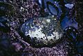
The Black Abalone is a native species to the Channel Islands. It was over-harvested in the past. Now, its population is low, and it is an endangered species.
In Popular Culture
- "26 Miles (Santa Catalina)" is a 1957 song about Santa Catalina Island.
- Scenes for the 1970s TV show Black Sheep Squadron were filmed around the islands.
- Some scenes for the TV show Bosch were set on Santa Cruz Island. They were filmed on Santa Catalina Island.
- Scott O’Dell's book Island of the Blue Dolphins is based on the true story of a Native American woman living alone on one of the Channel Islands.
- The Glass Bottom Boat is a 1966 movie that takes place on Santa Catalina Island.
- Catalina Caper is a 1967 movie that also takes place on Santa Catalina Island.
- San Miguel is a 2012 book by T. C. Boyle. It tells the story of families trying to run ranches on San Miguel Island.
Images for kids
-
A black abalone, an endangered species found in the Channel Islands.
See also
 In Spanish: Archipiélago del Norte para niños
