Santa Cruz Island facts for kids
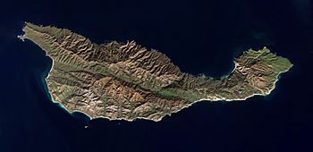
ESA satellite image of Santa Cruz Island
|
|
| Geography | |
| Coordinates | 34°00′N 119°43′W / 34.000°N 119.717°W |
| Area | 250 km2 (97 sq mi) |
| Length | 35 km (21.7 mi) |
| Width | 10 km (6 mi) |
| Highest elevation | 740 m (2,430 ft) |
| Highest point | Devils Peak |
| Administration | |
|
United States
|
|
| State | California |
| County | Santa Barbara |
| Demographics | |
| Population | Rangers and tourists are the only residents |
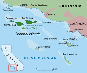
Santa Cruz Island (in Spanish: Isla Santa Cruz, in Cruzeño: Limuw) is a large island off the coast of Ventura, California, USA. It is the biggest island in California. It is also the largest of the eight islands in the Channel Islands group. This island is part of the Channel Islands National Park. Santa Cruz Island is about 22 miles (35 km) long and 2 to 6 miles (3 to 10 km) wide. Its total area is about 61,764 acres (250 square kilometers).
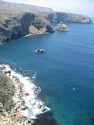
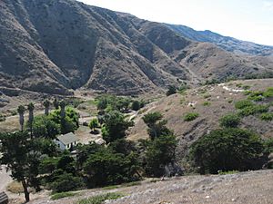
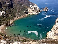
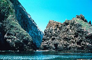
The island's coast has tall cliffs, big sea caves, small bays called coves, and sandy beaches. The highest point is Devils Peak, which is over 2,450 feet (740 meters) high. A valley runs through the middle of the island. This valley is formed by the Santa Cruz Island Fault. The northern part of the island has volcanic rock, while the southern part has older sedimentary rock. Many sea caves have formed in the volcanic rock. The biggest of these is Painted Cave, which is one of the largest in the world.
Santa Cruz Island is part of Santa Barbara County, California. In the year 2000, only two people lived on the island. Santa Cruz is the largest privately owned island off the continental United States. The island's ownership is split. The National Park Service owns 24% of the island. The other 76% is owned by The Nature Conservancy.
Santa Cruz Island is home to some special animals and plants. These are called endemic species, meaning they are found only there. One example is the Santa Cruz Island fox. This fox is a unique type of island fox.
Contents
Island History: Exploring Santa Cruz's Past
Early Island Life: Chumash People
Scientists believe people have lived on Santa Cruz Island for at least 10,000 years. The Chumash people called the island Limuw (place of the sea) or Michumash. The Chumash who lived here had a complex society. They relied on fishing and trading with people on the mainland.
In 1542, Juan Rodríguez Cabrillo was the first European to see the island. At that time, about 2,000 to 3,000 Chumash lived on the three northern Channel Islands. There were 11 Chumash villages on Santa Cruz Island.
In 1602, Sebastián Vizcaíno led another Spanish trip to California. His map named Santa Cruz Island the Isla de Gente Barbuda, which means "island of the bearded people." For over 150 years after that, no Europeans recorded visiting the island.
Spanish Explorers and Missions
In 1769, Don Gaspar de Portolà's expedition reached Santa Cruz Island. Two priests, Father Juan González Vizcaíno and Father Francisco Palóu, were with him. Father Palóu wrote that the missionaries were welcomed by the Chumash. The Chumash gave them fish, and the missionaries gave them beads. The Spanish thought about building a Catholic mission on the island. This mission would serve the many Chumash people.
However, Mission San Buenaventura was built on the mainland in 1782. This started the slow process of converting the Santa Cruz Chumash to Christianity. Diseases like measles caused the Chumash population to shrink. By 1822, the last Chumash left the island for missions on the mainland.
The island got its name, Santa Cruz, from Portolà's expedition. The Chumash returned a staff with an iron cross that the Spanish had left behind. Because of this, the Spanish named it La Isla de la Santa Cruz (island of the holy cross) on their 1770 map. George Vancouver used the same name on his map in 1793.
Mexican Rule and Early Settlers
After Mexico became independent from Spain in 1821, the Mexican government took control of California. To increase the Mexican population, they sent prisoners to California starting in 1830. About 31 prisoners were sent to Santa Cruz Island. They lived for a short time at a place now called Prisoners' Harbor. But they soon escaped to the mainland.
In 1839, Governor Juan Bautista Alvarado gave Santa Cruz Island as a Mexican land grant to Captain Andrés Castillero. When California became a US state in 1850, the US government required proof of land ownership. Castillero's claim was approved in 1860, and he received the official grant in 1867. Castillero then transferred the land to his agent, William Barron, in 1857.
Ranching History on Santa Cruz Island
William Barron was a businessman from San Francisco. He hired Dr. James Barron Shaw to manage the island. Shaw started a sheep ranch. He built corrals and homes and improved the roads. He brought cattle, horses, and sheep to the island. He also built one of the first docks in California at Prisoners' Harbor. Shaw was the first rancher to ship sheep to San Francisco by boat. By 1869, when he left, about 24,000 sheep lived on Santa Cruz Island.
In 1869, ten investors from San Francisco bought the island. Justinian Caire, a French immigrant, was one of them. He owned a successful hardware business. By 1886, Caire owned all the shares of the Santa Cruz Island Company. He wanted to create a self-sufficient ranch with sheep, cattle, vineyards, and fruit trees. He added nine more ranches across the island. In 1885, he had the largest private telephone system in the US. The island had 110 workers in 1889. By 1895, his winery produced 86,000 gallons of wine from a 200-acre vineyard.
After Justinian Caire died in 1897, his family continued the ranching and winemaking business. However, a long legal fight started in 1910 among his children. This led to parts of the island being sold. In 1937, most of Caire's family had to sell their part of the island to pay legal costs.
Edwin Stanton, an oilman from Los Angeles, bought the main part of the island. He changed the ranching from sheep to beef cattle. The beef industry was growing fast in California at that time. Stanton kept most of the old buildings but added new ones for his cattle ranch. He also improved the water system for the cattle.
The Gherini family, who were descendants of Justinian Caire, kept their sheep ranch on the east end of the island. They used Scorpion Ranch as their main base. They continued ranching until 1984.
National Park and Nature Preserve
In 1980, the Channel Islands National Park was created. The government wanted to buy the Gherini family's land, which was about 10% of the island. But the family and the government disagreed on the price. After 16 years, in 1996, the government bought the land for 14 million dollars. This allowed the park to open to the public. The last of the 10,000 sheep on the island were removed by 1999.
When Edwin Stanton died in 1964, his family continued the cattle business. His son, Carey Stanton, died in 1987. His land then went to The Nature Conservancy, a non-profit group. The Nature Conservancy quickly ended the cattle ranching. They also removed the last of the feral pigs by 2006. In 2000, The Nature Conservancy gave 8,500 acres (34 square kilometers) of land to the national park.
The National Park Service owns about 24% of Santa Cruz Island. The rest of the land is called the Santa Cruz Island Reserve. It is used for scientific research and education. This reserve is managed by The Nature Conservancy, the University of California Natural Reserve System, and the Santa Cruz Island Foundation. The Reserve provides places for students and researchers to stay.
Other Island Activities
Santa Cruz Island was also used by otter hunters, fishermen, and smugglers. The Channel Islands were good hiding places for smugglers and bootleggers. One such place is now called Smugglers Cove.
In the winter of 1835–36, George Nidever hunted otters on Santa Cruz Island. He and two others caught 60 otters that season. Fishermen also camped on the island, trading fish with passing boats.
Some movies were filmed on the island, including Peter Pan and The Rescue.
The Richfield Oil Corporation tried to find oil on the island in 1954 but did not succeed.
UC Santa Barbara started a summer geology class on the island in 1963. They opened the Santa Cruz Island Field Station in 1966.
From 1966 to 1985, the Santa Cruz Island Hunt Club operated. People hunted sheep and pigs there.
The United States military started using Santa Cruz Island during World War II. They built and kept important bases there. The island was an early warning post to spot enemy planes and ships. During the Cold War, a communications station was built as part of the Pacific Missile Range Facility. This station is still used today.
Island Wildlife, Plants, and Weather
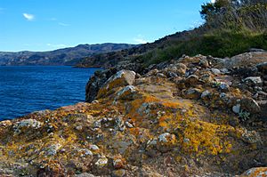
Animals and Plants: Native and Introduced Species
Some animals and plants were brought to Santa Cruz Island by humans. These are called introduced or invasive species. They include:
- Golden eagles: These birds arrived and hunted the native island foxes. This made the foxes an endangered species.
- Fennel: This plant provided cover for island foxes. But it was also food for the wild pigs.
- Feral pigs: These wild pigs pushed out the native island foxes.
- Santa Cruz sheep
- Santa Cruz Island horse
Native species are those that naturally live on the island. They include:
- Island scrub-jay: This bird is found only on Santa Cruz Island.
- Hoffman's rockcress: This plant is found only on Santa Cruz and Santa Rosa Islands.
- Island manzanita and whitehair manzanita: These shrubs are found only on Santa Cruz Island.
- Island fence lizard: This lizard is found only on the Channel Islands of California.
- Island foxes: These foxes are native to the island. They are about the size of housecats and are not afraid of people. You can often see them in the campgrounds.
The natural plant groups on Santa Cruz Island include chaparral, oak woodland, Bishop pine forests, grasslands, and coastal sage scrub. In areas where sheep grazed a lot, the native plants were damaged. This caused problems with erosion. But since the wild sheep and pigs were removed, the native plants are slowly growing back.
Bald Eagle Reintroduction: A Success Story
Bald eagles used to be common on California's Channel Islands. But chemicals like DDT made their eggshells thin. This caused bald eagles to stop nesting successfully by 1949. By the 1960s, there were no bald eagles left on any of the Channel Islands.
By 2013, there were five pairs of bald eagles nesting on Santa Cruz Island. There were also two pairs on Santa Rosa Island and one on Anacapa Island. In total, over 40 bald eagles lived on the northern Channel Islands. Between 2002 and 2006, the Channel Islands National Park helped reintroduce 61 young bald eagles. They used a method called "hacking." This involved keeping 8-week-old eagles in special towers on Santa Cruz Island. When the eagles were three months old, they were ready to fly.
On the Channel Islands, there are not many large trees. So, bald eagles have built nests on cliffs, rock ledges, and in island pines. In 2006, for the first time in over 50 years, a bald eagle chick hatched on Santa Cruz Island.
When bald eagles nest, they can keep golden eagles away. Golden eagles had been hunting the endangered island foxes. So, the return of bald eagles has also helped the island fox population recover.
Island Climate: Weather on Santa Cruz
The weather on Santa Cruz Island is mild. It rarely freezes, and snow is almost never seen, except sometimes on the highest mountains. The amount of rain changes a lot each year. Some years are wet, and some are dry. Most of the rain falls from November to March. Summers are dry, but they are often cloudy and cool with coastal fog.
| Climate data for Santa Cruz Island | |||||||||||||
|---|---|---|---|---|---|---|---|---|---|---|---|---|---|
| Month | Jan | Feb | Mar | Apr | May | Jun | Jul | Aug | Sep | Oct | Nov | Dec | Year |
| Record high °F (°C) | 86 (30) |
86 (30) |
94 (34) |
96 (36) |
101 (38) |
109 (43) |
109 (43) |
105 (41) |
104 (40) |
103 (39) |
97 (36) |
89 (32) |
109 (43) |
| Mean daily maximum °F (°C) | 64 (18) |
64 (18) |
65 (18) |
67 (19) |
69 (21) |
71 (22) |
73 (23) |
74 (23) |
74 (23) |
72 (22) |
68 (20) |
64 (18) |
69 (21) |
| Daily mean °F (°C) | 53 (12) |
54 (12) |
56 (13) |
58 (14) |
60 (16) |
63 (17) |
66 (19) |
66 (19) |
65 (18) |
62 (17) |
56 (13) |
52 (11) |
59 (15) |
| Mean daily minimum °F (°C) | 41 (5) |
44 (7) |
46 (8) |
48 (9) |
51 (11) |
54 (12) |
58 (14) |
58 (14) |
56 (13) |
51 (11) |
44 (7) |
40 (4) |
49 (9) |
| Record low °F (°C) | 24 (−4) |
25 (−4) |
30 (−1) |
33 (1) |
38 (3) |
41 (5) |
45 (7) |
43 (6) |
42 (6) |
31 (−1) |
30 (−1) |
20 (−7) |
20 (−7) |
| Average precipitation inches (mm) | 3.5 (89) |
4.1 (100) |
3.2 (81) |
1.0 (25) |
0.3 (7.6) |
0.1 (2.5) |
0 (0) |
0.1 (2.5) |
0.3 (7.6) |
0.8 (20) |
1.6 (41) |
2.9 (74) |
18 (460) |
| Source: The Weather Channel | |||||||||||||
Getting to Santa Cruz Island: Transportation
Santa Cruz Island has several airstrips. All of them are run by The Nature Conservancy:
- Santa Cruz Island Airport (SZN, KSZN, 44CA) used to have a 2,100-foot (640-meter) grass runway. This airport is no longer active.
- Christy Airstrip (CA97) has a 2,500-foot (760-meter) grass runway.
- Santa Cruz Ranch Airport (44CA) has a 1,697-foot (517-meter) grass runway.
See also
 In Spanish: Isla Santa Cruz (California) para niños
 | Audre Lorde |
 | John Berry Meachum |
 | Ferdinand Lee Barnett |


