San Miguel Island facts for kids
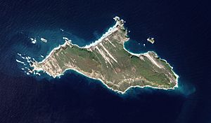
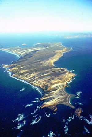
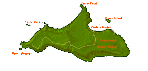
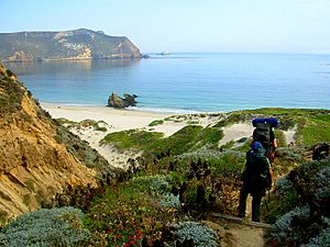
San Miguel Island (called Tuqan by the Chumash) is the westernmost of California's Channel Islands. It is located in the Pacific Ocean within Santa Barbara County, California. San Miguel is the sixth-largest of the eight Channel Islands, covering about 9,325 acres (3,774 ha). A smaller island called Prince Island is about 700 meters (2,300 ft) off its northeast coast.
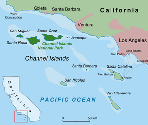
San Miguel Island is part of Channel Islands National Park. Most of the island is also a special archaeological area listed on the National Register of Historic Places. This island gets strong winds and rough weather from the open ocean. The cold, nutrient-rich water around the island is home to many different kinds of sea creatures. These animals are not found on the islands further south.
The island is not inhabited by people. Its highest point is San Miguel Hill, which is 831 feet (253 m) tall. The coastline is almost 28 miles (45 km) long. Hidden rocks underwater make it very dangerous for boats.
Contents
Island History
Long ago, in the Late Pleistocene period, ancient puffins lived on San Miguel Island. Scientists have also found fossils of a giant mouse and a dwarf mammoth from that time.
Archaeological studies show that people first lived on San Miguel Island about 13,000 years ago. Back then, San Miguel was part of a larger island called Santarosae Island. This bigger island was closer to the mainland when sea levels were lower. The first people to settle here, called Paleo-Indians, must have used boats. This is because the northern Channel Islands have never been connected to the mainland.
The island was home to the ancestors of the Chumash people for thousands of years. They developed a rich culture based on fishing, hunting, and gathering from the sea. The Chumash were not afraid of the rough seas. They called the island Tuquan. For many centuries, they built and used amazing canoes called tomols. These canoes were made from planks sewn together and sealed with natural tar. In their tomols, they fished and hunted. They also traded actively with people on other islands and the mainland.
Tuqan Man
In 2005, archaeologists found the skull and bones of a man buried on the island. He was buried between 9,800 and 10,200 years ago. This discovery happened because of beach erosion. Scientists studied the remains, but they could not get DNA from them. In May 2018, the remains were returned to the Chumash tribe. They were then reburied on the island.
A small type of dwarf mammoth once lived on Santarosae Island. These mammoths were related to the larger Columbian mammoths. They were already extinct for about 3,000 years before Tuqan Man died.
The oldest coastal shell midden (a pile of ancient shells and waste) in North America is at Daisy Cave on the island. People lived there about 11,500 years ago. A bone from a short-faced bear was found in the cave. It might have been carried there by a bird, as there is no other proof that these bears lived on the islands.
Chumash Villages
The Chumash people were skilled fishers. They used nets, spears, rods, lines, and hooks. When the explorer Juan Rodríguez Cabrillo visited in 1542, there were two Chumash villages on the island. About 100 people lived there. Cabrillo named his ship San Miguel. Later, George Vancouver gave the island the name San Miguel on his map in 1793. He got the name from a Spanish map.
Juan Rodríguez Cabrillo was the first European explorer to land on the island in 1542. He spent several weeks there while exploring the California coast. Cabrillo died on the island, and many believe he was buried there. The last of the island Chumash people were moved to mainland missions and towns in the 1820s. After that, San Miguel was mostly empty until ranchers started raising sheep there from 1850 to 1948.
Ranching and Government Ownership
For many years, different people leased the island for ranching. One family, the Lesters, managed the ranch for a long time. They left the island in 1942 during World War II because it became dangerous.
During World War II, the United States Navy had three sailors stationed on the island as lookouts. In 1943, a B-24 plane crashed into Green Mountain, killing all 12 people on board. In 1948, the Navy took back the island. They used it as a target area for guided missiles and bombing. The National Park Service started a visitor program in 1978. However, the Navy still owns the island.
Park Service Operations
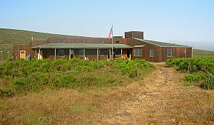
The National Park Service (NPS) manages San Miguel Island. They have two airstrips, a ranger station, and a research station there. Usually, a park ranger lives on the island. They make sure park rules are followed and help visitors. Scientists also come to the island to study pinnipeds (like seals and sea lions) and help with the island fox breeding program.
Island Animals
In 2011, scientists found that a colony of California common murres had returned to Prince Island. This was the first time since 1912! These black-and-white seabirds are like penguins. They use their wings to "fly" deep underwater, but they can also fly in the air. This colony disappeared almost a century ago, probably because people collected their eggs. Now, they are back.
In the 1960s, northern fur seals started living and breeding on San Miguel Island again. This made it the third breeding colony for these seals in America. By 2006, nearly 100 pups were born. Today, the San Miguel colony has about 10,000 seals. In 2016, 1,709 pups were born. Great white sharks are common in the waters around the island. They hunt seals and sea lions. Orcas (killer whales) also hunt the sharks.
Island Climate
San Miguel Island is not protected from the open ocean like the other Channel Islands. Most of the time, strong northwest winds blow across the island. These winds are usually faster than 25 mph (40 km/h) and can even go over 50 mph (80 km/h). When there is high pressure over the mainland, the winds often stop.
Heavy fog is common on the island, especially in May and June. On warmer days, the fog might clear up. But then, the strong northwest wind often brings in more fog from the ocean. On foggy days, the temperature rarely goes above 55°F (13°C). The cold and windy summer climate is more like Northern California than Southern California. The island gets about 17 inches (43 cm) of rain each year, mostly from November to March.
| Climate data for San Miguel Island (1981–2010) | |||||||||||||
|---|---|---|---|---|---|---|---|---|---|---|---|---|---|
| Month | Jan | Feb | Mar | Apr | May | Jun | Jul | Aug | Sep | Oct | Nov | Dec | Year |
| Mean daily maximum °F (°C) | 58.8 (14.9) |
58.8 (14.9) |
60.2 (15.7) |
63.9 (17.7) |
63.9 (17.7) |
66.7 (19.3) |
70.6 (21.4) |
70.1 (21.2) |
68.0 (20.0) |
68.0 (20.0) |
62.8 (17.1) |
62.6 (17.0) |
64.5 (18.1) |
| Daily mean °F (°C) | 54.5 (12.5) |
54.4 (12.4) |
54.1 (12.3) |
56.3 (13.5) |
56.9 (13.8) |
59.7 (15.4) |
62.7 (17.1) |
62.6 (17.0) |
61.5 (16.4) |
61.0 (16.1) |
56.7 (13.7) |
56.7 (13.7) |
58.1 (14.5) |
| Mean daily minimum °F (°C) | 50.2 (10.1) |
50.0 (10.0) |
47.9 (8.8) |
48.7 (9.3) |
49.8 (9.9) |
52.6 (11.4) |
54.7 (12.6) |
55.1 (12.8) |
54.9 (12.7) |
53.9 (12.2) |
50.5 (10.3) |
50.7 (10.4) |
51.6 (10.9) |
| Average rainfall inches (mm) | 2.33 (59) |
6.63 (168) |
2.03 (52) |
2.20 (56) |
0.19 (4.8) |
0.06 (1.5) |
0.11 (2.8) |
0.08 (2.0) |
0.09 (2.3) |
0.41 (10) |
0.24 (6.1) |
1.69 (43) |
16.06 (407.5) |
Visiting the Island
In May 2016, San Miguel Island was reopened for visitors. The U.S. Navy had spent two years checking 18 miles (29 km) of trails for any dangerous objects. The NPS guides all visitors and limits them to the marked trails. Visitors must sign a special permit and a waiver. You can get these permits at boat and air offices or at a self-registration station on the island.
Companies like Island Packers and Channel Islands Aviation offer rides to the island. Channel Islands Aviation provides flights when you need them. There is no transportation on the island itself. So, you can only explore by walking, or by using a private boat or kayak.
Landing on the Island
The ocean between Santa Rosa Island and San Miguel Island can have waves as high as 8 feet (2.4 m). San Miguel Island does not have a pier. All visitors arriving by sea land by small boat (skiff) at Cuyler Harbor. Landing can be tricky because waves can swamp the boat. On calm days, visitors land right in front of the trail. If the waves are high, visitors might land on a different part of the beach.
Camping Facilities
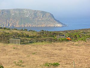
San Miguel Island has a campground with ten sites. Each campsite has a picnic table, a wind break, and a box to keep animals out of your food. The campground has one pit toilet. Fires are not allowed because of the strong winds and the danger of them spreading. It is a good idea to bring a strong tent. Winds can reach over 50 mph (80 km/h), even in summer. Campers should tie their tents to the wind break so they don't blow away.
Hiking on the Island
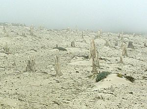
Most hiking on the island requires a ranger to lead the way. The only exception is the trail from the beach to the campground and ranger station. Many visitors take the 14-mile (23 km) round trip hike to Point Bennett. There, they can see thousands of elephant seals and sea lions. These animals live at the west end of the island during spring and summer. Another popular hike is to the island's caliche forest.
Water Activities
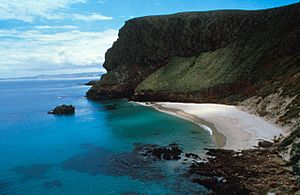
Visitors can only access the ocean at Cuyler Harbor. This area is protected from the strong ocean waves. Cuyler has a sandy beach, and you might share it with elephant seals. The water is usually below 60°F (16°C), so it's cold without a wetsuit. At low tide, the harbor has a tide pool area at the east end of the beach. Sea kayaking is not recommended for beginners. Strong winds can start suddenly. Swimmers, divers, and kayakers should be careful of adult great white sharks in these waters. Some sharks can be up to 18 feet (5.5 m) long. It is not wise to enter the water early in the morning or late in the afternoon when sharks are feeding close to shore.
See also
 In Spanish: Isla San Miguel (California) para niños
 | Laphonza Butler |
 | Daisy Bates |
 | Elizabeth Piper Ensley |


