
São Miguel Island facts for kids
Quick facts for kids São Miguel |
|
| Ilha de São Miguel | |
| Island (Ilha) | |
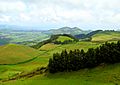
 Typical rural landscape of São Miguel island, Azores
|
|
| Official name: Ilha de São Miguel | |
| Name origin: Portuguese for Saint Michael | |
| Nickname: Ilha Verde | |
| Country | |
|---|---|
| Autonomous Region | |
| Islands | Eastern Group |
| Location | Azores Platform, Mid-Atlantic Ridge, Atlantic Ocean |
| Archipelago | Azores |
| Municipalities | Lagoa, Ponta Delgada, Povoação, Nordeste, Ribeira Grande, Vila Franca do Campo |
| Highest point | Pico da Vara |
| - location | Planalto dos Graminhais, Nordeste |
| - elevation | 1,104.74 m (3,624 ft) |
| - coordinates | 37°48′35″N 25°12′51″W / 37.80972°N 25.21417°W |
| Lowest point | Sea level |
| - location | Atlantic Ocean |
| - elevation | 0 m (0 ft) |
| Length | 63.54 km (39 mi), Northwest-Southeast |
| Width | 15.63 km (10 mi), Southwest-Northeast |
| Area | 744.57 km² (287 sq mi) |
| Population | 137,856 (2011) Census |
| Density | 185 /km² (479 /sq mi) |
| Biomes | Temperate, Mediterranean |
| Orogeny | Volcanism |
| Period | Holocene |
| Demonym | Micaelense |
| Ethnic groups | Portuguese |
São Miguel Island is the biggest and most populated island in the Azores archipelago. The Azores are a group of islands that belong to Portugal. São Miguel is also called "The Green Island" because of its lush landscapes.
The island is named after the Archangel Michael. About 138,000 people live here. The largest city on the island, and in all the Azores, is Ponta Delgada.
Contents
Island History
São Miguel was the second island in the Azores to be settled. This happened in 1427. People from mainland Portugal came to live here, led by Gonçalo Velho Cabral.
The first main town on the island was Vila Franca do Campo. But in 1522, a big earthquake and landslides destroyed it. Because of this disaster, Ponta Delgada became the new capital in 1546. It grew into the main center for business and government.
After the Portuguese Restoration War in 1640, São Miguel became an important trading hub. It started new connections with Brazil. Many old buildings, like fancy houses and churches, were built around this time. The island grew rich by selling oranges, mostly to Great Britain.
Later, after the Liberal Wars, the island's economy really boomed. The port in Ponta Delgada got bigger. New crops like tea, pineapple, and tobacco were exported. The growth of fishing, farming, and the dairy industry helped many towns on the island grow.
Island Geography
São Miguel Island covers an area of 744.57 square kilometers (287.5 square miles). It is a long, narrow island. It stretches 63.54 kilometers (39.48 miles) from southeast to northwest. The island is 15.63 kilometers (9.71 miles) wide from southwest to northeast.
Island Landscape

The island was formed by volcanoes and often has earthquakes. It has many mountains, especially in the middle. The highest mountain is Pico da Vara. These mountains have many valleys, deep gullies, and streams. There are no large rivers on the island.

São Miguel has an old mountain range in the east. It also has three large volcanoes called Sete Cidades, Fogo, and Furnas. The Sete Cidades volcano is famous for its huge caldera, which is a large bowl-shaped hollow. This caldera is 5 kilometers (3.1 miles) wide and about 350 meters (1,148 feet) deep. Inside it are two small lakes: Lagoa Verde (Green Lake) to the south and Lagoa Azul (Blue Lake) to the north.
In the eastern part of the island is Pico da Vara. This is the highest point on the island, reaching 1,103 meters (3,619 feet) high. In the center, the Sierra de Água de Pau is 940 meters (3,084 feet) high. To the west, the Caldeira das Sete Cidades is 850 meters (2,789 feet) high.
Pico da Vara is part of a special protected area. This area has the biggest remaining laurisilva forest on the island. This type of forest is home to the Azores Bullfinch, a bird that lives only here and is in danger of disappearing.
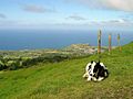
The island's rich soil is great for farming. It produces cereals, tea, grapes (for wine), fruits, and food for cattle.
Island Climate
Like other islands in the Azores, São Miguel's weather is affected by ocean currents and winds. The Gulf Stream helps keep the temperatures mild. Temperatures usually stay between 14 and 26 degrees Celsius (57 and 79 degrees Fahrenheit) all year. Rainfall happens throughout the year, but it rains more in the cooler months. The island's location also means it can be hit by Atlantic storms.
The climate in Ponta Delgada on São Miguel Island is known as a Csb climate. This is a type of Mediterranean climate.
| Climate data for Azores : Ponta Delgada | |||||||||||||
|---|---|---|---|---|---|---|---|---|---|---|---|---|---|
| Month | Jan | Feb | Mar | Apr | May | Jun | Jul | Aug | Sep | Oct | Nov | Dec | Year |
| Mean daily maximum °C (°F) | 16.5 (61.7) |
16.3 (61.3) |
16.7 (62.1) |
17.4 (63.3) |
18.7 (65.7) |
21.0 (69.8) |
23.7 (74.7) |
25.0 (77.0) |
24.0 (75.2) |
21.7 (71.1) |
19.4 (66.9) |
17.6 (63.7) |
19.8 (67.6) |
| Mean daily minimum °C (°F) | 11.5 (52.7) |
11.1 (52.0) |
11.5 (52.7) |
11.9 (53.4) |
13.1 (55.6) |
15.2 (59.4) |
17.2 (63.0) |
18.4 (65.1) |
17.9 (64.2) |
16.1 (61.0) |
14.3 (57.7) |
12.6 (54.7) |
14.2 (57.6) |
| Average precipitation mm (inches) | 112.4 (4.43) |
81.4 (3.20) |
84.8 (3.34) |
66.8 (2.63) |
64.2 (2.53) |
39.2 (1.54) |
27.3 (1.07) |
48.3 (1.90) |
97.0 (3.82) |
107.5 (4.23) |
122.0 (4.80) |
121.2 (4.77) |
972.1 (38.27) |
| Source: Weatherbase.com [1] | |||||||||||||
Island Towns and Cities
Most towns and cities on São Miguel are in flat areas. Some are along the coast, and a few are further inland. There are also communities inside old craters, like Sete Cidades, Furnas, or Povoação. Other towns are in river valleys or on coastal deltas.
São Miguel has two main cities: Ponta Delgada and Ribeira Grande.
Island Administration
The island is divided into six areas called municipalities (Portuguese: concelhos):
| Concelho | Population | Area (km2) |
Density (inhab./km2) |
Notes |
|---|---|---|---|---|
| Lagoa | 14,442 | 45.6 | 317 | This is the newest municipality on São Miguel. |
| Nordeste | 4,937 | 101.5 | 49 | It is known for its many plants and for having Pico da Vara, the island's highest point. |
| Ponta Delgada | 68,809 | 233.0 | 295 | This area includes the city of Ponta Delgada, which is industrial and commercial. It also has many rural areas and the large Sete Cidades crater. |
| Povoação | 6,327 | 106.4 | 59 | This was the first place people settled on the island. It is in the southeast and has active and inactive volcanoes, including Furnas. |
| Ribeira Grande | 32,112 | 180.2 | 178 | This is the second largest municipality. It was created in 1981 and covers a big part of the northern coast. |
| Vila Franca do Campo | 11,229 | 78.0 | 144 | This used to be the capital of São Miguel. It was almost destroyed by an earthquake and landslides in 1522. It is on the southern coast between Lagoa and Povoação. |
Images for kids
-
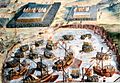
The landing of the Spanish Tercios at Terceira during the 1580 Portuguese succession crisis
-
An 1845 drawing of São Miguel island (west is up)
-
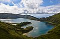
Lagoa do Fogo (Lake of Fire), seen from Miradouro da Serra da Barrosa, along the Água de Pau Massif
-
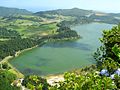
Lagoa das Furnas
-
Green fields in the Picos region, where two parts of the island joined together.
-
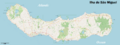
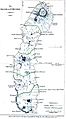
Detailed map of São Miguel Island
-
Ginetes, a town on the western coast of the island.
-
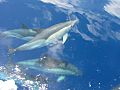
A species of common dolphins seen during one of whale watching tours
-
The Fonte de Buraco viewpoint overlooking the village of Maia, on the northern coast.
-
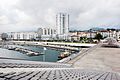
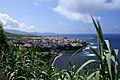
The center of Ponta Delgada, seen from the marina.
-
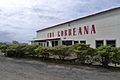
The main factory for Chá Gorreana tea.
-
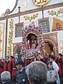
The cult of the Lord Holy Christ of the Miracles is a very popular religious event on São Miguel island.


.jpg)


See also
 In Spanish: Isla de San Miguel (Azores) para niños
