
Mount Wilson Toll Road facts for kids
Quick facts for kids
Mount Wilson Toll Road
|
|
|---|---|

The Mt Wilson Tollhouse seen along East Altadena Drive at Mendocino Lane
|
|
| Location | Angeles National Forest |
The Mount Wilson Toll Road was a special road that went up Mount Wilson in California. It was used from 1891 to 1936. This road started in Altadena and allowed vehicles to reach the mountain top.
You could get to the road from Pasadena by driving on Santa Anita Avenue. This street led right to the toll house, where people paid to use the road.
Even though cars can't use it anymore, the road is still open for hikers, bicyclists, and horses. You can access it from Eaton Canyon or from Pinecrest Drive in Altadena. Sometimes parts of the road have to close because of landslides. For example, a landslide in 2005 damaged 50 yards of the road. But it was fixed and reopened for everyone to enjoy.
People have been using Mount Wilson for a very long time. The local Native Americans traveled there first. Later, Benjamin Davis Wilson created a proper trail to the top of Mount Wilson. This trail started from Sierra Madre.
Building the Toll Road
In 1889, a large telescope from Harvard University was being moved up Mount Wilson. It was very difficult to transport the telescope on the old trail. This challenge made people realize they needed a better road to the mountain.
In June 1889, a judge named Benjamin Eaton gathered some important business people from Pasadena. They met to talk about building a road for wagons to Mount Wilson. Eighteen of these men agreed to put in money for the project. On July 12, 1889, they officially formed a company called "The Pasadena and Mount Wilson Toll Road Company." However, this first company didn't manage to build the road.
A few years later, five of the original investors tried again. They got new money for the project. Since the Harvard telescope had been moved, there was less interest in Mount Wilson. So, they decided to make the road smaller than first planned. Instead of a twelve-foot-wide road, they aimed for a four-foot-wide trail.
By June 1891, after only five months of work, a usable ten-mile (16 km) trail was ready. In July, the new toll road officially opened to the public. The fee was set by the Los Angeles County Board of Supervisors. Hikers paid 25 cents, and people on horseback paid 50 cents. This new road was called the "New Mt. Wilson Trail." It quickly became more popular than the old Sierra Madre trail. So many people and pack animals used it that in June 1893, the trail was made wider. It became six feet wide to make it easier for people and animals to go both ways.
Mount Wilson Observatories
Over time, the Mount Wilson Toll Road Company gained ownership of much of the popular land on the mountain. In 1896, they bought Strain's and Martin's camps. In 1901, they paid the United States Land Office $800 for 640 acres (2.6 km2) at the mountain top. By 1904, the company owned even more land, about 1,050 acres (4.2 km2).
In 1905, the company made a long-term agreement with the Carnegie Institution for Science. They provided 40 acres (160,000 m2) of the mountain top for a new observatory. Today, this is known as the Mount Wilson Observatory. People working at the new observatory could use the toll road for free. They also got half of the water rights on the mountain. In return, the Carnegie Institution agreed that the public would always be able to visit the observatory.
The new Carnegie Observatory made Mount Wilson popular again. Many sightseers came to the mountain top. To help these new visitors, the toll road company built a one-story hotel in 1905. It had small cottages around the main building for guests staying overnight. A fire destroyed this hotel in 1913. A larger hotel was built in its place, and it even had a big swimming pool.
As new, bigger telescopes were designed for the Carnegie Observatory, a road for cars became necessary. This was needed to carry large parts up the mountain. In 1907, the trail was made wider to ten feet. Most of this work was done by hand, with help from Japanese laborers and mules. The road was made even wider, to a full 12 feet (3.7 m), in 1917. This was to help transport parts for the 100-inch Hooker Telescope.
Even though the road was advertised for cars, drivers were often told not to use it. One reason was the fear of meeting large trucks carrying observatory parts. Drivers had to call ahead to the mountain to check. Also, the road had sharp turns that made driving dangerous. Mr. L. L. Whitman, who drove his 1907 Franklin up the mountain, said he would "not for five hundred dollar make the trip again." For those who didn't want to drive, there was a popular Mt. Wilson Stage Line.
Closing Years
By the early 1930s, a new, fast highway was being built. This highway went from La Cañada through the Arroyo Seco. The new Angeles Crest Highway was paved and ready for travel into Red Box Canyon. From there, you could reach Mount Wilson from the back side by 1935.
The historic Mount Wilson Toll Road closed to the public in March 1936. It was then given to the United States Forest Service.
Today, the road is a popular place for hiking. It leads to Henninger Flats and Mount Wilson. You can get onto the road from a gate on Pinecrest Drive in Altadena or from Eaton Canyon.
Images for kids
-
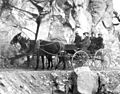
Horse and buggy passage on the Mount Wilson Trail.
-
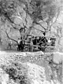
An early car on the Mt. Wilson Toll Road


