
Arroyo Seco (Los Angeles County) facts for kids
Quick facts for kids Arroyo Seco |
|
|---|---|

The Devil's Gate at the Arroyo Seco River prior to 1920 damming. Note the "devil's profile" in the rock to the right.
|
|
| Lua error in Module:Location_map at line 420: attempt to index field 'wikibase' (a nil value).
Location of the mouth of Arroyo Seco in California
|
|
| Country | United States |
| State | California |
| Physical characteristics | |
| Main source | San Gabriel Mountains near Red Box Gap, Angeles National Forest 5,200 ft (1,600 m) 34°16′10″N 118°06′19″W / 34.26944°N 118.10528°W |
| River mouth | Los Angeles River Glendale Narrows, near Lincoln Heights, United States of America 302 ft (92 m) |
| Length | 24.9 mi (40.1 km) |
| Basin features | |
| Basin size | 46.7 sq mi (121 km2) |
| Tributaries |
|
The Arroyo Seco is a 24.9-mile (40.1 km) long stream in Los Angeles County, California. Its name means "dry stream" in Spanish. It is a seasonal river, which means it doesn't always have water flowing in it. The Arroyo Seco is also a canyon, a watershed (an area where all water drains to one place), and an important cultural spot.
Spanish explorer Gaspar de Portolà explored this area in 1770. He named the stream Arroyo Seco because it had less water than other canyons he had seen. During his trip, he met Chief Hahamog-na of the Tongva Native Americans.
Contents
The Arroyo Seco Waterway
The Arroyo Seco starts high up in the San Gabriel Mountains. Its source is at Red Box Saddle in the Angeles National Forest, near Mount Wilson. As it flows into the city areas, the stream passes between La Cañada Flintridge and Altadena.
Flowing Through Cities
Just below the Devil's Gate Dam, the stream goes under the Foothill Freeway. At the north end of Brookside Golf Course, the stream becomes a flood control channel. This means it's put into a man-made path to control water flow. It then continues south through the golf course.
The Arroyo Seco flows through Pasadena, passing by the famous Rose Bowl Stadium. The water from the Arroyo Seco helps fill the Raymond Basin. This is an underground water source that provides about half of Pasadena's water.

The stream then goes under the Ventura Freeway and the beautiful Colorado Street Bridge. It crosses the Raymond Fault at the edge of Pasadena. The channel continues along the western side of South Pasadena. Then it flows into northeast Los Angeles, passing through neighborhoods like Highland Park and Cypress Park.
The Arroyo Seco finally joins the Los Angeles River near Elysian Park. This is north of Dodger Stadium and Downtown Los Angeles. The Arroyo Seco Parkway, also known as the Pasadena Freeway, runs next to the channelized Arroyo Seco.
History of the Arroyo Seco
The Arroyo Seco has a rich history, from ancient Native American stories to modern transportation routes.
Native American Stories
Above Devil's Gate, the rapids of the Arroyo Seco make a unique sound, like beating or laughing. The Tongva-Gabrieliño people have a traditional story about this sound. They say it comes from a bet between the river and the coyote spirit.
Early Settlements
The Arroyo Seco area is considered the birthplace of Pasadena. After the Spanish missions closed in the 1820s, the land became part of the Mexican land grant called Rancho San Pascual. This area is now Pasadena.
Early settlers built their homes along Orange Grove Boulevard, which runs next to the Arroyo. However, the deep canyon and seasonal floods made it hard to travel between Pasadena and Los Angeles. People told stories of it taking many hours just to cross the canyon.
Transportation Routes
The Arroyo Seco canyon has always been an important path for travel. It connects downtown Los Angeles with Pasadena and the San Gabriel Mountains.
.jpg)

By 1886, the Los Angeles and San Gabriel Valley Railroad built a large wooden bridge across the Arroyo. This bridge helped connect downtown Los Angeles. Later, it became part of the cross-country Santa Fe Railroad. Electric trolleys, known as "Red Cars" and "Yellow Cars," also ran through the Arroyo Seco, connecting many areas.

In 1900, Pasadena Mayor Horace Dobbins tried to build the California Cycleway. This was an elevated wooden path for bicycles to travel from Pasadena to Los Angeles. Only a small part was built before cars became popular. Today, there's an Arroyo Seco bicycle path for cyclists.

The Colorado Street Bridge was opened in 1913. This beautiful bridge crosses the Arroyo, connecting to areas like Glendale. After an earthquake in 1989, the bridge was closed for safety. It was fully repaired and reopened in 1993.
Arroyo Seco Parkway

In 1940, the Arroyo Seco Parkway was built. It was the first freeway in California. It runs next to the flood channel in the Arroyo. Today, it's also called the Pasadena Freeway. It connects to the Harbor Freeway and goes all the way to San Pedro.
Floods and Flood Control
The Arroyo Seco usually has a small amount of water. But sometimes, heavy rains in the mountains cause huge floods. These floods used to rush down the stream and overflow into cities like Pasadena and Los Angeles. Major floods happened in 1914 and 1916, causing a lot of damage.
Devil's Gate Dam

To control these floods, the Los Angeles County Flood Control District built the first flood control dam in Los Angeles County. This was in 1920 at the Devil's Gate gorge. The gorge was named for a rock that looks like a devil's face.
The dam creates a flood basin above it, which collects water from the mountain watershed. This area is now called "Hahamongna". This name means "Flowing Waters, Fruitful Valley" in the language of the Tongva tribe.
In 2011, the basin filled up with mud and debris from the 2009 Station Fire. This made the dam less effective. So, a big project began in 2019 to remove the extra sediment. This helps the dam work better to prevent floods.

Below Devil's Gate Dam, most of the Arroyo Seco is in a concrete channel. This channel helps control stormwater and runoff from the city. These channels were built after a huge flood in 1938.
Restoration Efforts
For over 100 years, people have worked to protect and improve the Arroyo Seco. Groups like the Arroyo Seco Foundation were created to save the area for recreation and wildlife.
Many studies and programs have been done to help the Arroyo Seco. These efforts aim to:
- Make sure the flood control system works well.
- Manage and save water resources, and improve water quality.
- Create better recreational opportunities and protect natural open spaces.
One success is the reintroduction of the Arroyo chub. This native fish used to live in the stream but disappeared because of flood control changes. Now, it's back!
Jet Propulsion Laboratory (NASA JPL)
The Jet Propulsion Laboratory (JPL) was built at the mouth of the Arroyo Seco. Early rocket testing happened here in 1936. By the 1960s, JPL became very important for NASA. They developed and launched unmanned space probes, like the Mars rover, which sends back amazing pictures from Mars.
JPL has been working to clean up the local groundwater. In the past, some chemicals from rocket testing got into the water. Now, a big cleanup project is underway to remove these toxins.
Trout Restoration
Before the stream was put into channels, the Arroyo Seco was a home for Steelhead trout. These fish are a type of rainbow trout that swim from the ocean to freshwater to lay eggs. Even after channelization, some rainbow trout lived here until 2009. Mudslides from the Station Fire (2009) were thought to have wiped them out.
But in 2020, the California Department of Fish and Wildlife brought nearly 500 trout from another river. This successfully brought native trout back to the Arroyo Seco!
Arroyo Seco Crossings
Many bridges and roads cross the Arroyo Seco. Here are some of the main crossings from the mouth to the source:
- Railroad
- North Avenue 19 (1956)
- North San Fernando Road (1913)
 I-5 - Golden State Freeway (1962)
- West Avenue 26 (1939)
- Metro A Line Railroad Bridge (1940)
- Pasadena Avenue (1940)
- East Avenue 43 (1939)
- Sycamore Grove Park [Pedestrian Bridge] (1940)
- South Avenue 60 (1909)
- Santa Fe Arroyo Seco Railroad Bridge carrying Metro A Line (1896)
- York Boulevard (1912)
 SR 110 - Arroyo Seco Parkway (1939)
- San Pasqual Avenue (1939)
- La Loma Road (1914)
- Colorado Street Bridge carrying West Colorado Boulevard (1913)
 SR 134 - Ventura Freeway (1953)
- North Arroyo Boulevard (1927)
- West Holly Street (1925)
- Seco Street (1939)
- Rose Bowl Parking Lot [2 Pedestrian Bridges]
- Brookside Golf Course [7 Pedestrian Bridges]
- West Washington Boulevard (1939)
 I-210 - Foothill Freeway (1974)
- Oak Grove Drive (1955)
- Devil's Gate Dam
- Explorer Road
- Forest Route 2N70 (2002)
Attractions and Landmarks
The Arroyo Seco is a popular place for outdoor activities and has many interesting spots.
Upper Arroyo – Mountain Section

The mountainous part of the Arroyo Seco is inside the Angeles National Forest. It's a favorite spot for hiking in Southern California. The Angeles Crest Highway runs along the western edge of the canyon.
Some popular spots in the Upper Arroyo include:
- Teddy's Outpost Picnic Area
- Gould Mesa Campground
- Niño Picnic Area
- Paul Little Picnic Area
- Oakwilde Campground
- Switzer's Picnic Area
- Red Box Station (at the canyon's start)
- Switzer Falls
- Dawn Mine
- Millard Canyon – with its impressive waterfall.
The Gabrielino Trail is a popular path for hikers, horseback riders, and bicyclists. A favorite hike is the 4-mile round trip to lower Switzer Falls.
Lower Arroyo – City Section
The urban part of the Arroyo Seco has many landmarks:
- Jet Propulsion Laboratory (NASA JPL)
- Oak Grove Disc Golf Course
- Hahamongna Watershed Park
- Devil's Gate Dam
- Brookside Golf Course
- Rose Bowl – a famous stadium and flea market
- Brookside Park
- Kidspace Children's Museum
- Colorado Street Bridge
- Lower Arroyo Park Archery Range
- Lower Arroyo Seco Historic District
- Arroyo Seco Parkway
- Los Angeles Metro Rail A Line (with a bridge crossing and Highland Park station)
- Southwest Museum of the American Indian
- "El Alisal" – Lummis House – a historic home and native plants gardens.
- Heritage Square Museum – a park with historic Victorian houses.
- Los Angeles River Center and Gardens Park
- The spot where the Arroyo Seco joins the Los Angeles River.
Gallery
-
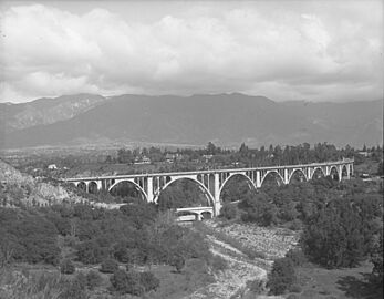
The Colorado Street Bridge over the Arroyo, with the San Gabriel mountains in the background, around 1920.
-
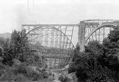
1913 view looking north at the Colorado Street Bridge over the Arroyo, under construction and the Scoville Bridge behind.
-
ColoradoStreetBridge1914.jpg
1914 Colorado Street Bridge just completed, and the Scoville Bridge, that a flood washed away later.
-
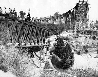
A 1913 view of the Scoville Bridge next to the partially completed Colorado Street Bridge.
-
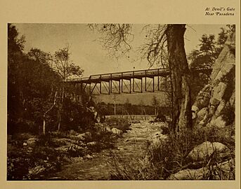
"At Devil's Gate Near Pasadena" 1904


