Sierra Madre, California facts for kids
Quick facts for kids
Sierra Madre, California
|
|||
|---|---|---|---|
 |
|||
|
|||
| Motto(s):
"Village of the Foothills"
|
|||
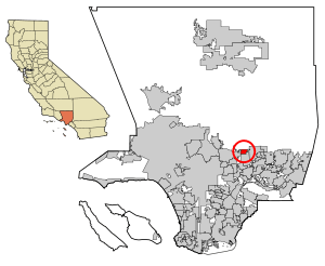
Location of Sierra Madre in Los Angeles County, California
|
|||
| Country | United States | ||
| State | California | ||
| County | Los Angeles | ||
| Incorporated | February 2, 1907 | ||
| Government | |||
| • Type | Council–manager | ||
| Area | |||
| • Total | 2.96 sq mi (7.65 km2) | ||
| • Land | 2.95 sq mi (7.64 km2) | ||
| • Water | 0.00 sq mi (0.01 km2) 0.15% | ||
| Elevation | 827 ft (252 m) | ||
| Population
(2020)
|
|||
| • Total | 11,268 | ||
| • Estimate
(2022)
|
10,809 | ||
| • Density | 3,818.4/sq mi (1,412.10/km2) | ||
| Time zone | UTC-8 (PST) | ||
| • Summer (DST) | UTC-7 (PDT) | ||
| ZIP codes |
91024, 91025
|
||
| Area code | 626 | ||
| FIPS code | 06-71806 | ||
| GNIS feature IDs | 1661439, 2411897 | ||
Sierra Madre is a city in Los Angeles County, California. Its name means "mother range" in Spanish. In 2020, about 11,268 people lived there.
The city is located in the foothills of the San Gabriel Valley. It sits below the southern edge of the Angeles National Forest. To its west are Pasadena and Altadena. Arcadia is to its south and east. Sierra Madre is known as "Wisteria City" because of a very large wisteria vine. Its city seal even has a drawing of this famous vine. It is also called the "Village of the Foothills" and won the All-America City Award in 2007.
History of Sierra Madre
Early Beginnings of the City
Around 500 CE, the Tongva Indians moved to the area that is now Los Angeles County. They were the native people of this land. Their name means "People of the Earth." They spoke a language from the Uto-Aztecan Shoshonean family.
In the 16th century, there were about 25 Tongva villages. About 400 people lived in each village. By 1769, the first Spanish settlers arrived. They found about 5,000 Tongva people living in 31 villages. Sierra Madre was once a Tongva settlement called Sonayna.
Two years later, in 1771, Mission San Gabriel Arcangel was started in what is now Montebello. The mission later moved to San Gabriel. This was because the Rio Hondo River flooded badly and ruined their crops. The Tongva people became part of the mission's culture. The Spanish called them Gabrielino Indians.
The first Mount Wilson trail was made by the Gabrielino Indians. They used it to carry timber from the mountains. This timber was used to build the San Gabriel Mission in 1771.
Growth and Development
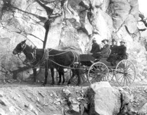
In 1864, Benjamin "Don Benito" Wilson made the Mount Wilson Trail bigger. He used Mexican and Chinese workers. In 1881, Nathaniel Carter bought the land that became Sierra Madre. This was about 1,103 acres (4.5 km2).
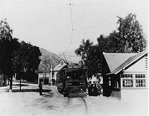
The Santa Anita railroad station was built in 1888. In 1906, the Pacific Electric Railway "Red Car" passenger service came to Sierra Madre. Later that year, Edison Electric Company installed the first electric lights. In December 1906, the first telephones were put in. There were 250 of them.
On February 2, 1907, the first city election was held. 96 citizens voted, and 71–25 decided to make Sierra Madre an official city. The population was about 500 people. Eighteen days after the election, Sierra Madre became an incorporated California city. Charles Worthington Jones was the first mayor.
The New Century in Sierra Madre
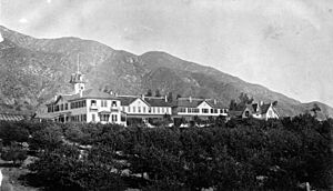
Sierra Madre has a history linked to the mountain resorts in the San Gabriel Mountains. The Sierra Madre Villa Hotel was one of the first summer resorts in the late 1800s. The city also managed "Lizzie's Trail" inn at the start of the Old Mount Wilson Trail.
Harvard College built the first Mount Wilson Observatory in 1889. Moving the telescope up the old trail was hard. This led to interest in building a road, not just a trail, to Mount Wilson. The Harvard telescope was removed. In July 1891, a new toll road opened to the public. Hikers paid 25 cents, and horseback riders paid 50 cents. This new road was called the "New Mt. Wilson Trail." It was very popular. In June 1893, the trail was made wider, to 6 feet (1.8 m).
The Pacific Electric "Red Cars" ran to Sierra Madre from 1906 to 1950. Thousands of people rode these cars to hike the original Mt. Wilson Trail.
In 1908, the first Mt. Wilson Trail Race was held. This yearly race stopped during World War II. It started again in 1966. The race course changes almost every year due to weather. No official records of running times are kept. The 8.6-mile (13.8 km) course starts and ends on pavement. Most of the race is on a dirt path about 3 feet (0.9 m) wide. The trail has steep drops. Because it is narrow and steep, only 300 male and 300 female runners can join. The path goes up over 2,100 feet (640 m). Orchard Camp is the halfway point, 4.3 miles (6.9 km) from the start. Scout troops provide water at two spots. The Sierra Madre Search and Rescue Team helps on race day. This race is a valued tradition in the community.
In 1908, Catholic families asked Father M. W. Barth to hold Mass for them. He founded St. Rita's parish in 1908. The first small church was finished in 1910. In 1922, St. Rita's Catholic Church school opened. Over 100 years, St. Rita's Parish has recorded many baptisms, confirmations, marriages, and funerals. Today, over 1,200 Catholic families belong to the parish.
In 1914, the city gained control of all water rights and systems from the Baldwin Estate and the Sierra Madre Water Company.
The 1920s and 1930s
In 1921, a bad bakery fire led to the official start of the Sierra Madre Volunteer Fire Department. Sierra Madre had the last volunteer fire department in the greater Los Angeles region. It became a paid department in 2017.
On January 1, 1922, Bethany Temple was opened. This historic domed cobblestone church was designed by Louis D. Corneulle, who was nearly blind. A new Congregational Church building was completed on Sierra Madre Avenue. It was designed by Marsh, Smith, & Powell. In July 1927, the Sierra Madre Kiwanis Club was formed.
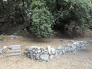
On April 21, 1931, the Sierra Madre Historical Society held its first meeting. This was part of the city's 50th anniversary. In 1936, Central Avenue was officially renamed Sierra Madre Boulevard. In March 1938, a big storm caused floods. It destroyed many resorts in the local mountains. The John Muir Lodge in Big Santa Anita Canyon was also ruined. No trace of it remains today. In 1940, the city bought 760 acres (3.1 km2) of land in the San Gabriel Mountains. This was near Orchard Camp, to protect the water supply.
A six-week Wisteria event happened in the 1930s. Over 100,000 people came to see the giant Wisteria vine. Extra "Red Cars" were added to the Pacific Electric route to Sierra Madre for these crowds.
The 1940s
On May 14, 1942, Japanese residents of Sierra Madre had to leave for a detention facility in Tulare, California. During this time, the Sierra Madre Civic Club and the Sierra Madre Lions Club were started. The Sierra Madre Community Nursery School also opened. In May 1947, the first Pioneer Days Parade was held. The heaviest snow ever recorded in Sierra Madre happened in 1949. The town was covered with 3 to 4 inches (7.6 to 10.2 cm) of snow overnight.
In 1948, the U.S. Supreme Court made a ruling in the case of Shelley v. Kraemer. This ended rules that stopped Black people from owning homes in Sierra Madre and nearby cities. However, housing patterns had already been set. It wasn't until 1968 that real estate agents regularly showed homes to Black people.
Mid-Century Changes
On October 6, 1950, the last Pacific Electric train left Sierra Madre. In 1951, the Sierra Madre Search and Rescue Team was created. Sierra Madre joined the Pasadena Unified School District in 1961. In 1967, Princess Margaret visited the British Home in Sierra Madre.
The Cultural Heritage Committee was formed in 1969. Its goal was to find and protect important cultural and beautiful landmarks in the city. Also in 1969, the city bought the Women's Clubhouse. It was torn down to build a new City Hall.
The Sierra Madre Historical Wilderness Area was created on January 24, 1967. When it opened on January 27, 1968, Sierra Madre was the first city in Southern California to own a wilderness preserve. The Sierra Madre City Council added the Mt. Wilson Trail to its list of Historic Cultural Landmarks on October 12, 1993.
The 1970s and Beyond
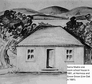
In January 1971, the Sierra Madre Environmental Action Council was formed. In 1974, the Bell Tower in Kersting Court was dedicated. It holds the original school bell from the 1885 schoolhouse. In 1976, Sierra Madre Vistas was published by the Sierra Madre Historical Preservation Society. A Bicentennial time capsule was buried in May 1976. The new City Hall building was dedicated in 1977.
In 1981, Sierra Madre celebrated its 100th birthday. There was a special celebration with a royal court, a dance, and a Historical Society dinner. A Pacific Electric red car was even brought back to town for Independence Day weekend.
Recent History
In 2003, work began on the Senior Housing Project on Esperanza Avenue. This project provides affordable homes for seniors. Later that year, the Veterans' Photo Wall was dedicated in Memorial Park. In 2007, Sierra Madre celebrated 100 years since it became a city. It also won the All-America City Award. That same year, a refurbished World War I cannon was dedicated in Memorial Park.
In March 2008, the Milton & Harriet Goldberg Recreation Area was opened. This was the city's first new small park in over 30 years. In 2009, the Sierra Madre Historical Preservation Society published a book called Southern California Story: Seeking the Better Life in Sierra Madre.
In 2023, the city asked the California Department of Fish and Wildlife to change how it handles bears in the city.
Geography and Climate of Sierra Madre
Sierra Madre covers about 3.0 square miles (7.7 km2). Most of this area is land.
The city has warm, dry summers and cool, wet winters. This is called a Mediterranean climate. It gets about 24 inches (61 cm) of rain each year. Most of the rain falls between November and March. In the fall, strong winds called Santa Ana winds can make daytime temperatures warm, even in winter. Winters usually have cool, rainy days followed by warm, sunny ones. Frost is rare, and snow has only been recorded three times.
By May, Pacific storms stop visiting the area. In May and June, hot desert air and cool ocean water create low clouds each morning. These are called the Marine Layer. They usually disappear by noon. These clouds make June the cloudiest month, even though it gets little rain. From July to October, it is very hot. September is the hottest month, which is different from most of the country. It rarely rains during this time.
| Climate data for Sierra Madre, California (1897-1958 averages) | |||||||||||||
|---|---|---|---|---|---|---|---|---|---|---|---|---|---|
| Month | Jan | Feb | Mar | Apr | May | Jun | Jul | Aug | Sep | Oct | Nov | Dec | Year |
| Record high °F (°C) | 93 (34) |
92 (33) |
98 (37) |
105 (41) |
104 (40) |
113 (45) |
118 (48) |
117 (47) |
111 (44) |
108 (42) |
101 (38) |
93 (34) |
118 (48) |
| Mean daily maximum °F (°C) | 63.8 (17.7) |
65.2 (18.4) |
67.5 (19.7) |
71.1 (21.7) |
74.1 (23.4) |
80.4 (26.9) |
88.2 (31.2) |
88.5 (31.4) |
86.0 (30.0) |
78.7 (25.9) |
73.2 (22.9) |
66.4 (19.1) |
75.3 (24.0) |
| Mean daily minimum °F (°C) | 45.1 (7.3) |
45.6 (7.6) |
46.7 (8.2) |
48.9 (9.4) |
51.3 (10.7) |
54.5 (12.5) |
59.1 (15.1) |
59.8 (15.4) |
58.7 (14.8) |
55.0 (12.8) |
51.6 (10.9) |
47.2 (8.4) |
52.5 (11.4) |
| Record low °F (°C) | 21 (−6) |
26 (−3) |
29 (−2) |
31 (−1) |
32 (0) |
41 (5) |
45 (7) |
43 (6) |
41 (5) |
36 (2) |
26 (−3) |
25 (−4) |
21 (−6) |
| Average rainfall inches (mm) | 4.93 (125) |
4.68 (119) |
4.17 (106) |
2.11 (54) |
0.85 (22) |
0.20 (5.1) |
0.03 (0.76) |
0.06 (1.5) |
0.38 (9.7) |
1.06 (27) |
1.77 (45) |
3.79 (96) |
24.03 (611.06) |
| Average snowfall inches (cm) | 0.4 (1.0) |
0.0 (0.0) |
0.0 (0.0) |
0.0 (0.0) |
0.0 (0.0) |
0.0 (0.0) |
0.0 (0.0) |
0.0 (0.0) |
0.0 (0.0) |
0.0 (0.0) |
0.0 (0.0) |
0.0 (0.0) |
0.4 (1.0) |
The 1991 Sierra Madre earthquake was a 5.8 magnitude earthquake. It happened on June 28, 1991. It caused damage in the area, like knocking over chimneys. It also broke cinder block walls along major roads.
Sierra Madre is located between Santa Anita Boulevard to the east and Michillinda Avenue to the west. To the south, it borders Orange Grove Boulevard. Its main road is Sierra Madre Boulevard.
Population of Sierra Madre
| Historical population | |||
|---|---|---|---|
| Census | Pop. | %± | |
| 1910 | 1,303 | — | |
| 1920 | 2,026 | 55.5% | |
| 1930 | 3,550 | 75.2% | |
| 1940 | 4,581 | 29.0% | |
| 1950 | 7,273 | 58.8% | |
| 1960 | 9,732 | 33.8% | |
| 1970 | 12,140 | 24.7% | |
| 1980 | 10,837 | −10.7% | |
| 1990 | 10,762 | −0.7% | |
| 2000 | 10,578 | −1.7% | |
| 2010 | 10,917 | 3.2% | |
| 2019 (est.) | 10,793 | −1.1% | |
| U.S. Decennial Census | |||
Population in 2010
The 2010 United States Census showed that Sierra Madre had 10,917 people. This means there were about 3,692 people per square mile (1,425 per km2).
Most people were White (82.1%). About 7.6% were Asian. About 14.9% of the people were Hispanic or Latino.
There were 4,837 households. About 24.9% of these had children under 18. The average household had 2.26 people. The average family had 2.89 people.
About 19.2% of the population was under 18. About 17.4% was 65 or older. The average age in Sierra Madre was 46.6 years. For every 100 females, there were about 90 males.
Most homes (61.8%) were owned by the people living in them. The rest (38.2%) were rented.
From 2009 to 2013, the average household income in Sierra Madre was $88,837. About 8.3% of the people lived below the poverty line.
Population in 2000
In the census of 2000, there were 10,578 people living in Sierra Madre. There were 4,756 households. The population density was about 3,523 people per square mile (1,360 per km2).
The racial makeup was mostly White (85.8%). About 5.6% were Asian. About 6.0% of the people were Hispanic or Latino.
About 23.1% of households had children under 18. The average household size was 2.20 people. The average family size was 2.87 people.
About 18.9% of the population was under 18. About 15.7% was 65 or older. The average age was 43 years.
The average income for a household was $65,900. For a family, it was $79,588. About 3.7% of the population lived below the poverty line.
Arts and Culture in Sierra Madre
Downtown Sierra Madre has many small restaurants and shops. Sierra Madre celebrates Independence Day each year with a parade and three days of fun. Residents call it a "Star Spangled Weekend." Instead of water guns, people now throw "confetti eggs" during the parade. There are also concerts, food booths, and games.
In the northern part of the city are the Lower and Upper Sierra Madre Canyons. These areas have narrow, winding roads and lots of plants. They offer views of the San Gabriel Valley. Many small bungalows or cabins are found here. Bailey Canyon Wilderness Park has hiking trails for everyone. These include the Sierra Madre Wilderness Trail, Live Oak Nature Trail, and Canyon View Nature Trail. The park also has a Native Botanical Area and picnic areas with barbecues.
The Famous Wisteria Vine
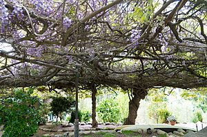
Sierra Madre is famous for its yearly Wistaria Festival. This festival celebrates a huge Chinese wisteria vine. It was planted in the 1890s and covers about 1 acre (4,000 m2). The Guinness Book of World Records has called it the largest flowering plant. It is also one of the seven amazing plant wonders of the world. The festival is the only day each year when the public can see this vine, which is on private property.
Mrs. William (Alice) Brugman bought the wisteria vine in 1894 for 75 cents. Over time, the vine grew so big that it crushed the house it was growing on. Now, the vine spreads across two backyards on North Hermosa Avenue. It is over 500 feet (150 m) long and weighs 250 tons.
Sierra Madre in the Rose Parade
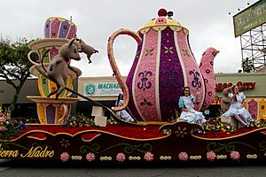
On January 1, 1917, Sierra Madre first entered the Pasadena Tournament of Roses parade. Since 1954, the Sierra Madre Rose Float Association (SMRFA) has organized volunteers. These volunteers decorate the city's floats every year. The association does not get money from the city.
The SMRFA holds a design contest each year. Volunteers start building the float frame in March. They then prepare for screening, painting, and decorating. The busiest time is "deco week," a 6-day period that ends with judging on December 31. Many volunteers are from Sierra Madre, but some come from other parts of the country and even other countries.
The Sierra Madre Rose Float Association and designer Charles Meier have won many awards. They often win against large corporate floats with much bigger budgets. Some recent awards include:
- 2022: Nature's Classroom – "Judges Award" for outstanding design.
- 2020: Ka Lā Hiki Ola – "President Award" for best use of flowers.
- 2019: Harmony's Garden – "Director Trophy" for beautiful artistic design.
- 2018: Chivalry! – "Fantasy Trophy" for amazing imagination.
- 2017: The Cat's Away – "Mayor’s Trophy" for outstanding city entry.
- 2016: Rollin' on the River – "Animation Trophy."
- 2015: I Think I Can – "Mayor’s Trophy" for outstanding city entry.
- 2014: Catching the Big One – "Mayor’s Trophy" for outstanding city entry.
- 2013: The Sky's the Limit – "Isabella Coleman Trophy" for best use of color.
- 2011: Sueños de California – "Governor's Trophy" for best depiction of California life.
- 2010: California Girls – "Governor's Trophy" for best depiction of California life.
- 2009: Bollywood Dreams – "Lathrop K. Leishman Award" for most beautiful non-commercial float.
- 2008: Valentine's Day – "Princess’ Trophy" for most beautiful float under 35 feet.
- 2007: Our Wonderful Wistaria – "Lathrop K. Lieshman Award" for most beautiful non-commercial float.
- 2006: Wonder of Reading – "Founder's trophy" for outstanding volunteer-built float.
Mater Dolorosa Monastery
In the foothills of Sierra Madre, there is an 80-acre (32 ha) retreat called Mater Dolorosa Monastery. It has a fountain and gardens. The first building was built in 1931. A new retreat house was built in 1949. Mater Dolorosa means "Mother of Sorrows." It offers a peaceful place for monks and others.
Before the Rose Bowl game in 1958, Ohio State Coach Woody Hayes looked for a quiet place for his team. The Mater Dolorosa monastery offered a calm setting. The Buckeyes won the game. Other team coaches have used the monastery since then.
Education in Sierra Madre
Sierra Madre has several preschool options. These include Sierra Madre Community Nursery School (SMCNS), Sunnyside School House Preschool, Bethany Christian School, and St. Rita Catholic School.
The public schools in the city are Sierra Madre Elementary School and Sierra Madre Middle School. They are part of the Pasadena Unified School District. Private schools include Alverno Heights Academy, Bethany Christian School, St. Rita School, and The Gooden School.
Media in Sierra Madre
Sierra Madre has two local newspapers: Sierra Madre Weekly and the Mountain Views News. There is also an online news source called Sierra Madre News.Net.
City Services and Transportation
City Services
The Sierra Madre Police Department protects the city 24 hours a day. Sierra Madre is the last city in Los Angeles County to provide its own paramedic service. The city has considered hiring other cities or the county to provide police and paramedic services.
Fire Department
The Sierra Madre Fire Department provides fire protection. Until 2017, Sierra Madre had a volunteer fire department.
Transportation Options
Sierra Madre has no traffic lights, except at its borders with Pasadena and Arcadia.
In July 2003, the MTA started the Gold Line (now part of the A Line) train service. It runs from Union Station to Sierra Madre Villa. Sierra Madre added local bus service to connect with this new train line.
The City of Sierra Madre offers transportation on a Gateway bus. Pasadena Transit Route 60 connects to the Metro A Line's Sierra Madre Villa station. Los Angeles County Metro also offers a microtransit service called Metro Micro in Sierra Madre.
Historic Landmarks in Sierra Madre
Forty-eight properties in Sierra Madre are listed as Designated Historical Properties. These include:
- Sierra Madre Pioneer Cemetery (1884)
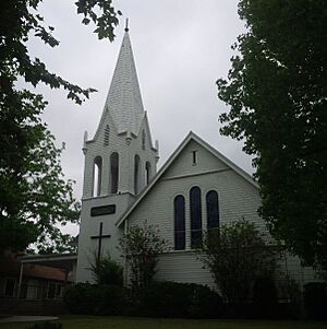
- Old North Church (1890)
- The Episcopal Church of the Ascension (1888)
- Hart's house (1884) in Sierra Madre Memorial Park
Notable People from Sierra Madre
- Annemarie Davidson (1920–2012) – An artist known for copper enamel work.
- Louise Gunning – A former Broadway singer.
- Jill Emery – Original bassist for the rock band Hole.
- Alan Wood – Supplied the American flag for the famous Raising the Flag on Iwo Jima photograph.
- Gutzon Borglum – The sculptor of Mount Rushmore.
|
See also
 In Spanish: Sierra Madre (California) para niños
 | Leon Lynch |
 | Milton P. Webster |
 | Ferdinand Smith |


