
Ballona Creek facts for kids
Quick facts for kids Ballona Creek |
|
|---|---|

As seen from Baldwin Hills, the eastern end of Ballona creek near La Cienega Boulevard.
|
|
| Country | United States |
| State | California |
| Region | Los Angeles County |
| Cities | Los Angeles, Culver City |
| Physical characteristics | |
| Main source | Los Angeles, California 110 ft (34 m) 34°02′39″N 118°21′12″W / 34.04417°N 118.35333°W |
| River mouth | Playa del Rey - Venice, Los Angeles 0 ft (0 m) 33°57′37″N 118°27′33″W / 33.96028°N 118.45917°W |
| Basin features | |
| Tributaries |
|
Ballona Creek is a river in Los Angeles County, California. It is about 8.8-mile-long (14.2 km). This river flows through a busy city area.
The land that drains into Ballona Creek is called its watershed. This area includes parts of western Los Angeles. It stretches from the Santa Monica Mountains in the north to the Baldwin Hills in the south.
The creek starts in the eastern part of Los Angeles. It then flows through Culver City and Del Rey. Finally, it reaches the ocean at Santa Monica Bay. This is between Marina del Rey and Playa del Rey.
Contents
Discovering Ballona Creek's Past

Long ago, before Europeans arrived, the Tongva people lived here. They were hunters and gatherers. They had small villages all over the Ballona Creek area. Their way of life changed when Spanish explorers came.
In 1769, the Tongva people met Europeans for the first time. This happened when the Portolá expedition passed through. A diarist named Fray Juan Crespi wrote about their journey. He noted a stream flowing southwest from a grove of alder trees. Researchers believe this was the start of Ballona Creek.
Around 1820, a rancher named Augustine Machado grazed cattle here. He claimed a large piece of land. This land was called the Ballona or Paseo de las Carretas grant. The creek and lagoon are named after this grant. The families who owned the land came from Baiona, Spain.
After the Mexican–American War, California became a state. Over time, the land claims were lost. The area then grew very quickly. Open land turned into farms and new towns. These included Culver City, Venice, and Santa Monica.
Understanding the Ballona Creek Watershed

The Ballona Creek watershed covers about 130 square miles (340 km2). Most of this land is used for homes (64%). There are also businesses (8%), factories (4%), and open spaces (17%).
Other smaller streams flow into Ballona Creek. These include Centinela Creek and Sepulveda Canyon Channel. Many smaller streams have been covered up by buildings. Now, they flow underground through storm drains.
Long ago, the Los Angeles River used to join Ballona Creek. But in 1825, a big flood changed the Los Angeles River's path. After that, Ballona Creek became its own separate waterway.
Much of Ballona Creek's above-ground section is now lined with concrete. This was done to control floods. It was part of a big project after the Los Angeles flood of 1938.
Climate and Water Flow
The Ballona Creek watershed has a Mediterranean climate. This means it has mild, wet winters and hot, dry summers. It gets about 15 inches of rain each year.
The amount of water flowing in the creek changes a lot. During dry weather, it's a small trickle. But during a big storm, it can become a fast-moving river. The Ballona Wetlands and Del Rey Lagoon are connected to the creek's mouth. Ocean tides flow into these areas twice a day.
Bridges and Connecting Streams
Many roads and paths cross over Ballona Creek. Here are some of them, from where the creek starts to where it meets the ocean:
- South Cochran Avenue
- South Burnside Avenue (1974)
- Hauser Boulevard (1974)
- Thurman Avenue (1974)
- South Fairfax Avenue (1962)
- Interstate 10 (1964)
- La Cienega Boulevard (1937)
- Washington Boulevard (1938)
- National Boulevard north (1967)
- Metro E Line (1909)
- National Boulevard south (1967)
- Higuera Street (1938)
- Duquesne Avenue (1938)
- Overland Avenue (1938)
- Westwood Boulevard (Pedestrian Bridge)
- Sepulveda Boulevard (1985)
- Sawtelle Boulevard (1988)
- Interstate 405 (1960)
- Sepulveda Channel enters
- Inglewood Boulevard (1937)
- South Centinela Avenue (1938)
- State Route 90 (1972)
- Centinela Creek enters
- Lincoln Boulevard/State Route 1 (1937)
- Culver Boulevard (1937)
- Pacific Avenue (Bridge to Bike Path)
Nature and Protecting the Creek
The area where Ballona Creek meets the ocean used to be a large wetland. It covered about 2,000 acres (810 ha). Most of this wetland was drained and built on. But some parts are still protected.
The State of California owns about 600 acres (240 ha) of the old wetlands. This land is now called the Ballona Wetlands Ecological Reserve. Even though it has been changed over time, it is getting better.
Many plants grow in the wetlands. These include pickleweed, marsh heather, and saltgrass. You can also find coyote bush and laurel sumac. Many special birds live or visit the reserve. These include the Belding's Savannah sparrow and the California least tern.
Water Quality Challenges
Because the area around the creek is so developed, the water quality has suffered. Rainwater and runoff from the city carry pollution into the creek. Ballona Creek has too much bacteria, heavy metals, and pesticides. These come from urban runoff and stormwater. This pollution harms the creek and its estuary.
Fun Things to Do at Ballona Creek
The Ballona Creek area has many interesting places. These include historical sites and educational spots.
A popular activity is riding bikes on the Ballona creek bicycle path. This path is almost 7 miles (11 km) long. It goes from Culver City to the end of the creek. Many people also enjoy watching birds along the creek.
Ballona Creek in Movies
Ballona Creek has even appeared in movies! In the 1997 movie Volcano, the main character, Mike Roark, diverts a river of lava into Ballona Creek. This sends the lava into the Pacific Ocean.
Images for kids
-
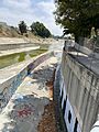
Benedict Canyon Creek Channel enters Ballona Creek
-
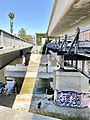
Three bridges over Ballona Creek: Expo Line Bikeway (formerly National Blvd. north) to the left, E Line track overhead, and long-derelict Pacific Electric Santa Monica Air Line route to the right; with bypassing jogger on Ballona Creek Bike Path below.
-
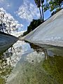
Above-ground “headwaters” of Ballona tributary Centinela Creek, near La Cienega Boulevard (click and zoom to see shopping cart)
-
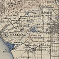
Ballona watershed, 1900
-
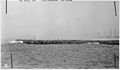
Ballona Creek, view of north levee from south levee, 1942; note oil drilling platforms on the right, where Marina Del Rey and Ballona Lagoon are located today.
-
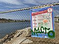
Multilingual sign warning of five species of contaminated fish in Ballona Creek


