Morris Dam facts for kids
Quick facts for kids Samuel B. Morris Dam |
|
|---|---|

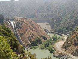
Morris Dam viewed from the unofficial overlook on State Route 39 (Spillway on left and dam on right)
|
|
| Country | United States |
| Location | Los Angeles County, California |
| Coordinates | 34°10′29″N 117°52′52″W / 34.17472°N 117.88111°W |
| Status | Operational |
| Construction began | 1932 |
| Opening date | 1934 |
| Construction cost | $25 million |
| Owner(s) | Los Angeles County Flood Control District |
| Dam and spillways | |
| Type of dam | Concrete gravity |
| Impounds | San Gabriel River |
| Height | 245 ft (75 m) |
| Length | 750 ft (230 m) |
| Spillway type | Gated concrete overflow |
| Spillway capacity | 80,000 cu ft/s (2,300 m3/s) |
| Reservoir | |
| Creates | Morris Reservoir |
| Total capacity | 39,300 acre⋅ft (48,500,000 m3) (nominal) 27,800 acre⋅ft (34,300,000 m3) (current) |
| Surface area | 417 acres (169 ha) |
| Normal elevation | 1,152 ft (351 m) |
| Power station | |
| Installed capacity | N/A |
Morris Dam, also known as the Samuel B. Morris Dam, is a large concrete dam in California. It stretches across the San Gabriel River and creates a lake called Morris Reservoir. This reservoir is located right below another dam, the San Gabriel Dam.
The dam was built in the 1930s to help supply water to the city of Pasadena. Today, its main jobs are to control floods and manage river flow. This helps to refill underground water supplies. Morris Dam is in northern Los Angeles County, within the Angeles National Forest. It's just a few miles northeast of Azusa. From the 1940s to the 1990s, the reservoir was even used by the United States military for testing underwater missiles!
Exploring the Dam's Design and Location
Morris Dam is nestled between Silver Mountain and Glendora Ridge. These mountains create the deep San Gabriel Canyon, which is about 1,500 feet (460 m) deep. The dam is about 37 miles (60 km) upstream from where the San Gabriel River flows into the Pacific Ocean. It's also about 6 miles (9.7 km) downstream from where the river starts, at the meeting point of its East and West Forks.
Morris Reservoir is about 3 miles (4.8 km) long. When it's full, its surface is about 1,152 feet (351 m) above sea level and covers 417 acres (169 ha). The very top of the dam itself is a bit higher, at 1,161 feet (354 m).
This dam is a "gravity dam," which means it's so heavy and thick that its own weight holds back the water. It has a slightly curved shape and an Art Deco style. The dam stands 245 feet (75 m) tall and is 750 feet (230 m) long. Its spillway, which lets extra water out, is a concrete channel with three steel gates. When the reservoir was first built, it could hold 39,300 acre-feet (48,500,000 m3) of water. However, over time, dirt and sand have built up, reducing its capacity by about 29%. Now, it holds about 27,800 acre-feet (34,300,000 m3) when full.
A Look Back at the Dam's History
Morris Dam was almost named Pine Canyon Dam. But it was renamed after Samuel Brooks Morris, who was the chief engineer in charge of building it for the Pasadena Water Department. Construction began in April 1932 and finished in May 1934, just four months later than planned. When it was completed, former United States President Herbert Hoover officially dedicated the dam.
In 1935, the dam was sold to the Metropolitan Water District of Southern California (MWD). This was different from its original plan to be a private dam for Pasadena. The MWD owned it for most of the 20th century.
The dam was finished just before the huge Los Angeles flood of 1938. This was the worst flood recorded in Southern California in a very long time. Morris Dam, along with San Gabriel Dam (which was still being built) and Cogswell Dam upstream, greatly helped to reduce the flood's impact on the San Gabriel River. This saved cities downstream millions of dollars in damages. Without these three dams, the water flow past Azusa could have been over 150,000 cu ft/s (4,200 m3/s). But the dams limited it to just 65,700 cu ft/s (1,860 m3/s). Morris Dam alone helped reduce the flood peak by about 30,000 cu ft/s (850 m3/s).
Morris Reservoir's Secret Military Past
Starting in World War II, Morris Reservoir became a secret testing site for the U.S. Navy. They worked with the California Institute of Technology to test many different weapons, including torpedoes and ballistic missiles. This testing continued until the 1990s. Most of the buildings from the military base were torn down, but you can still see their concrete foundations from State Route 39, which goes past the dam and reservoir. In 1995, the MWD sold the dam to the Los Angeles County Department of Public Works, which still manages it and the reservoir today.
 | Misty Copeland |
 | Raven Wilkinson |
 | Debra Austin |
 | Aesha Ash |


