Mount Morris Dam facts for kids
Quick facts for kids Mount Morris Dam |
|
|---|---|
 |
|
|
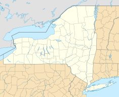
Location of Mount Morris Dam in New York
|
|
| Country | United States |
| Location | Livingston County |
| Coordinates | 42°44′00″N 77°54′25″W / 42.733333°N 77.906944°W |
| Status | In use |
| Construction began | 1948 |
| Opening date | 1952 |
| Owner(s) | U.S. Army Corps of Engineers |
| Dam and spillways | |
| Impounds | Genesee River |
| Height | 230 ft (70 m) |
| Length | 1,028 ft (313 m) |
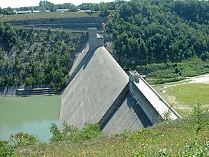
The Mount Morris Dam is a huge concrete wall built across the Genesee River in New York. It's a special kind of dam called a "dry dam." This means it usually doesn't hold back water. Instead, it waits for floods.
The dam is located at the top end of Letchworth State Park. It sits between the towns of Leicester and Mount Morris. This amazing structure is the biggest dam of its kind east of the Mississippi River. Its main job is to stop floods from damaging towns and farms downstream.
Contents
Why Was the Dam Built?
Before the dam was built, the Genesee River often flooded. The valley and the city of Rochester suffered a lot. For example, a huge flood in 1865 caused massive damage. The river flowed as fast as half of Niagara Falls!
Big floods happened about every seven years between 1865 and 1950. Smaller projects, like building walls in Rochester, were not enough. A major solution was needed to protect people and property.
Building a Giant Dam
The U.S. Army Corps of Engineers (USACE) built the Mount Morris Dam. Construction started in 1948 and finished in 1952. The United States Congress approved the project in 1944. It cost about $25 million to build.
The dam is a "gravity dam." This means its huge weight holds it in place against the force of the water. It's a very strong and stable design.
How the Dam Protects Us
Since it was finished, the dam has prevented a lot of damage. Experts estimate it has saved over $1 billion in flood costs. It works by holding back floodwaters when the river gets too high.
In June 1972, a big storm called Hurricane Agnes hit the Genesee Valley. Over 7 inches of rain fell quickly. The dam held back a huge amount of water. It prevented about $210 million in damages during that storm alone. Without the dam, the flooding would have been much worse.
Celebrating the Dam's History
In June 2002, people celebrated the dam's 50th birthday. A special event honored the workers who built it. A commemorative kiosk was dedicated to them. It has bricks with the names of the builders and their jobs.
Visiting the Dam
You can visit the William B. Hoyt II Visitor Center at Mount Morris Dam. The USACE opened it in 1999. Thousands of people visit the dam every year.
The center is quite large, about 5,400 square feet. It has a big open area, a museum, and a theater. It's a great place to learn about the dam and its history.
Amazing Facts About the Dam
- The dam is about 67 miles from where the Genesee River flows into Lake Ontario.
- It collects water from an area of about 1,075 square miles.
- The dam is 1,028 feet long, which is longer than three football fields!
- It stands 230 feet tall above the riverbed. That's as high as a 20-story building.
- The top of the dam is 790 feet above sea level.
- When there's a big flood, the reservoir behind the dam can stretch for 17 miles.
- The dam has special openings at its base. These "outlet works" help control the water flow.
See Also
 | Georgia Louise Harris Brown |
 | Julian Abele |
 | Norma Merrick Sklarek |
 | William Sidney Pittman |


