San Antonio Dam facts for kids
Quick facts for kids San Antonio Dam |
|
|---|---|
| Country | United States |
| Location | Monterey County, California |
| Coordinates | 35°47′53″N 120°53′07″W / 35.79806°N 120.88528°W |
| Opening date | 1965 |
| Owner(s) | Monterey County Water Resources Agency |
| Dam and spillways | |
| Type of dam | Earth dam |
| Impounds | San Antonio River |
| Height | 202 feet (62 m) |
| Length | 1,433 feet (437 m) |
| Elevation at crest | 802 feet (244 m) |
| Width (crest) | 30 feet (9.1 m) |
| Dam volume | 4,200,000 cubic yards (3,200,000 m3) |
| Reservoir | |
| Creates | Lake San Antonio |
| Total capacity | 350,000 acre-feet (430,000,000 m3) |
| Catchment area | 353 square miles (910 km2) |
| Surface area | 5,720 acres (2,310 ha) |
| Normal elevation | 781 feet (238 m) |
The San Antonio Dam is a large structure built across the San Antonio River in Monterey County, California, in the United States. It's an "earthen dam," which means it's made mostly of soil, sand, and rocks.
This dam creates a big lake called Lake San Antonio. This lake holds a lot of water, about 350,000 acre-feet. An acre-foot is the amount of water needed to cover one acre of land with water one foot deep. That's a huge amount of water! The lake is located west of Camp Roberts.
When Was the Dam Built?
The San Antonio Dam was finished in 1965. It has been helping to manage water in the area for many years.
How Does the Dam Work?
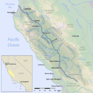
The main job of the San Antonio Dam is to control the flow of water in the San Antonio River. Water that is let out from the dam travels down this river. Eventually, it joins the Salinas River. The Salinas River then carries this water all the way to Monterey Bay on the Pacific Ocean. This process helps manage water for different uses, like farming and keeping the river healthy.
Are There Other Dams with the Same Name?
Yes, it can be a bit confusing! There is another dam with the same name. This other dam is located on San Antonio Creek in San Bernardino County, California. So, if you hear "San Antonio Dam," make sure you know which one people are talking about!
 | Jewel Prestage |
 | Ella Baker |
 | Fannie Lou Hamer |


