Upland, California facts for kids
Quick facts for kids
Upland, California
|
|||||
|---|---|---|---|---|---|
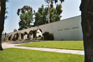
460 N Euclid Ave in Upland
|
|||||
|
|||||
| Nickname(s):
The City of Gracious Living
|
|||||
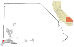
Location of Upland in San Bernardino County, California (left) and of San Bernardino County in California (right)
|
|||||
| Country | United States | ||||
| State | California | ||||
| County | San Bernardino | ||||
| Incorporated | May 15, 1906 | ||||
| Area | |||||
| • Total | 15.62 sq mi (40.45 km2) | ||||
| • Land | 15.58 sq mi (40.36 km2) | ||||
| • Water | 0.03 sq mi (0.09 km2) 0.21% | ||||
| Elevation | 1,237 ft (377 m) | ||||
| Population
(2020)
|
|||||
| • Total | 79,040 | ||||
| • Density | 5,060.2/sq mi (1,954.0/km2) | ||||
| Time zone | UTC-8 (Pacific Time Zone) | ||||
| • Summer (DST) | UTC-7 (PDT) | ||||
| ZIP Codes |
91784–91786
|
||||
| Area code | 909 | ||||
| FIPS code | 06-81344 | ||||
| GNIS feature IDs | 1661606, 2412137 | ||||
Upland is a city in San Bernardino County, California, United States. It sits right next to Los Angeles County. The city is about 1,242 feet (379 meters) above sea level. In 2020, about 79,040 people lived there. This was more than the 73,732 people counted in 2010.
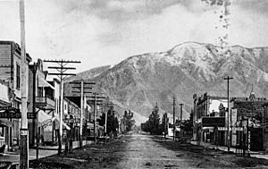
Upland became an official city on May 15, 1906. Before that, it was called North Ontario. Upland is at the base of the tall San Gabriel Mountains. It is part of the Inland Empire, a large area east of Greater Los Angeles.
Contents
Discovering Upland's Past
Early History and Trails
Upland is located where an old trail used to be. Native Americans and Spanish missionaries traveled this path. It is now part of the Old Spanish Trail. To the west, this trail led to the San Gabriel Mission, built by Spanish missionaries in 1771.
In 1774, a Spanish explorer named Juan Bautista de Anza found a land route from Arizona to California. Part of his trail went through what is now Upland. This path led to the San Gabriel Mission. In 1775, Anza led a bigger group of over 240 people on a long journey. They reached the San Gabriel Mission in January 1776. Later, they founded the city of San Francisco. In 1781, Spanish settlers used Anza's route to start the city of Los Angeles.
The San Gabriel Mission became an important stop for travelers. It was the first place to get supplies after crossing the desert. In 1810, a group from the mission explored the area. They named the valley "San Bernardino" after a saint. The area around Upland was called "Cucamonga," which means "sand place" in the Tongvan language.
Jedediah Smith was the first American to travel to California by land. He arrived at the San Gabriel Mission in November 1826. California was part of Mexico then. Smith was briefly arrested before being released.
In 1829, Mexican explorer Antonio Armijo led the first successful trade group from Santa Fe to Southern California. This opened the Old Spanish Trail. People traded goods between New Mexico and California. Mule trains traveled over the Cajon Pass and through Upland. They went to the San Gabriel Mission and Los Angeles.
The land around Upland was used for cattle ranching by the San Gabriel Mission. After Mexico took over the missions, the Cucamonga Rancho became a large ranch. In 1886, the Cucamonga Rancho was about 13,045 acres.
How Upland Was Founded
California became part of the United States in 1846. Many American settlers arrived during the California Gold Rush of 1849. The land where Upland is now was mostly empty ranchland. This changed when George Chaffey arrived in 1882.
Chaffey was a shipbuilder from Ontario, Canada. He had already started an irrigation community called Etiwanda in 1881. He bought over 8,000 acres of land in the Cucamonga Rancho. He also bought rights to water from San Antonio Creek.
Chaffey planned to send water to every farm using cement pipes. He also designed the main road, which he named Euclid Avenue. Euclid Avenue was seven miles long and very wide. It had a park in the middle and drives on each side. Chaffey also planned for street lamps and an electric streetcar. The new settlement, called Ontario, opened for people to buy land on November 1, 1882.
To make sure his water plan worked, Chaffey created the San Antonio Water Company. Every landowner became a part-owner of the water company.
Ontario became known for its citrus groves. At first, other fruits like peaches and pears were planted. By 1889, about 2,000 acres of citrus trees were growing. Ontario became the second largest citrus growing area in California.
The northern part of Chaffey's Ontario Model Colony became the city of Upland. It was first called "North Ontario" or "Magnolia." The name "Upland" was first used by the "Upland Citrus Association." By 1902, the name "Upland" was used for the whole area of North Ontario.
The railway came to North Ontario in 1887. A train station was built, costing $7,000. Many packing houses were built near the tracks. The railroad connected Upland to Los Angeles and other cities. It was used for both people and goods.
Ontario became an official city in 1891. In 1901, people in Ontario learned that North Ontario wanted to become its own city. To stop this, Ontario expanded its city limits.
Upland residents were worried about Ontario's expansion plans. Ontario wanted to include the Upland Post Office and the train station. On May 5, 1906, Upland residents voted to become their own city. The vote passed with 183 in favor and 19 against. Upland officially became a city on May 15, 1906.
Upland's Later Years
Upland's first hospital, the San Antonio Hospital, opened in 1907. It had 18 beds. A larger hospital was built in 1924. It had 35 rooms and could hold 50 patients.
In 1911, Upland started a volunteer fire department. Their first fire truck was a hose cart pulled by people. In 1913, a big fire destroyed many businesses. This led to building a fire station in 1915 and buying the first motorized fire engine. In 2017, the Upland Fire Department joined the San Bernardino County fire district.
Upland was on the National Old Trails Road, the first national highway across the country, started in 1912. In Upland, this highway followed Foothill Boulevard. In 1926, part of this road became the famous Route 66.
A trolley line once ran down the middle of Euclid Avenue. It connected Upland to Ontario. A mule pulled the trolley uphill to Upland. Then, the mule rode in a trailer back down. The trolley later became electric and closed in 1928.
The citrus industry grew strong in Upland. By the 1930s, citrus was a huge crop in California. In 1936, the citrus industry made $97,000,000. This was second only to California's oil industry. At its peak, the citrus industry produced 60% of the nation's citrus. After World War II, land became very expensive. Farmers started selling their land to developers, and the citrus industry declined.
In 1954, the San Bernardino Freeway was finished. This freeway, later part of Interstate 10, connected Los Angeles to San Bernardino. It made it easier to travel to Los Angeles. This helped Upland change from a farming area to a community with homes and businesses.
Upland's Location and Climate
Upland is on the northern edge of the San Bernardino Valley. The San Gabriel Mountains are to the north. The city's land is mostly flat but gently rises towards the north. The elevation increases by 825 feet from the south to the north. The highest mountain in the San Gabriels, Mount San Antonio (Mount Baldy), is about 9.5 miles north of Upland. It is 10,064 feet tall.
Upland shares borders with several other cities. To the east is Rancho Cucamonga. To the south are Ontario and Montclair. To the west is Claremont. To the north is the community of San Antonio Heights.
Upland has a semi-dry climate. Most of the rain falls during the winter months. The average yearly rainfall is 24.5 inches. The hottest temperature ever recorded was 113°F (45°C) in July 2006. The coldest was 21°F (-6°C) in January 1963. Upland has a warm-summer Mediterranean climate.
| Climate data for Upland, California | |||||||||||||
|---|---|---|---|---|---|---|---|---|---|---|---|---|---|
| Month | Jan | Feb | Mar | Apr | May | Jun | Jul | Aug | Sep | Oct | Nov | Dec | Year |
| Mean daily maximum °F (°C) | 68 (20) |
69 (21) |
71 (22) |
76 (24) |
79 (26) |
87 (31) |
92 (33) |
94 (34) |
90 (32) |
80 (27) |
74 (23) |
68 (20) |
79 (26) |
| Mean daily minimum °F (°C) | 43 (6) |
45 (7) |
47 (8) |
49 (9) |
54 (12) |
58 (14) |
62 (17) |
62 (17) |
60 (16) |
55 (13) |
47 (8) |
42 (6) |
52 (11) |
| Average precipitation inches (mm) | 3.1 (79) |
4.8 (120) |
2.6 (66) |
1.2 (30) |
0.2 (5.1) |
0.1 (2.5) |
0.0 (0.0) |
0.0 (0.0) |
0.2 (5.1) |
1.1 (28) |
1.6 (41) |
2.4 (61) |
17.3 (437.7) |
Who Lives in Upland?
| Historical population | |||
|---|---|---|---|
| Census | Pop. | %± | |
| 1910 | 2,384 | — | |
| 1920 | 2,912 | 22.1% | |
| 1930 | 4,713 | 61.8% | |
| 1940 | 6,316 | 34.0% | |
| 1950 | 9,203 | 45.7% | |
| 1960 | 15,918 | 73.0% | |
| 1970 | 32,551 | 104.5% | |
| 1980 | 47,647 | 46.4% | |
| 1990 | 63,374 | 33.0% | |
| 2000 | 68,393 | 7.9% | |
| 2010 | 73,732 | 7.8% | |
| 2020 | 79,040 | 7.2% | |
| 2022 (est.) | 78,841 | 6.9% | |
| U.S. Decennial Census | |||
Population in 2020
The 2020 United States Census showed Upland had 79,040 people. This means about 4,721 people lived in each square mile. Most people (60.6%) were White. About 6.5% were African American, and 8.9% were Asian. About 9.6% were from two or more races. Many people (44.1%) were Hispanic or Latino.
There were 26,654 homes. On average, 2.88 people lived in each home. In 30.6% of homes, a language other than English was spoken. Most homes (90.1%) had internet, and 94.7% had a computer.
About 21.8% of the people were under 18 years old. About 14.9% were 65 or older. More than half the population (51.9%) was female. About 17.6% of the people were born outside the United States.
More than half the homes (54.6%) were owned by the people living in them. The average rent was $1,571.
The average household income in Upland was $76,259. About 11.3% of the people lived below the poverty line. Most people (66.3%) aged 16 and older were working. They spent about 31.1 minutes traveling to work.
Upland's Economy
Major Employers
Here are the top employers in Upland, based on a 2019 report:
| # | Employer | # of Employees |
|---|---|---|
| 1 | San Antonio Community Hospital | 2,400 |
| 2 | Upland Unified School District | 1,037 |
| 3 | The Home Depot | 340 |
| 4 | Upland Rehabilitation & Care Center | 320 |
| 5 | Walmart | 315 |
| 6 | Lewis Group of Companies | 312 |
| 7 | Target | 265 |
| 8 | Lowe's | 254 |
| 9 | City of Upland | 250 |
| 10 | Holliday Rock Co. | 250 |
Fun Things to Do in Upland
Museums to Explore
- Upland Fire Department Museum: This museum is in the city's first fire station, built in 1915. It shows old firefighting equipment and photos. You can even see Upland's first fire truck from 1916!
- Cooper Regional History Museum: This building used to be the office for a fruit exchange. It was built in 1937. The museum shows the history of wine and citrus in the area. It also has photos and tools from Native Americans.
- Inland Empire Museum of Art (IEMA): This art museum started in 2015. It is a nonprofit group that relies on donations.
Festivals and Events
The Upland Lemon Festival started in 1997. It happens every April. This festival celebrates the city's history with citrus fruits. It includes a singing contest called Lemon Idol. There are also food competitions and carnival rides. The festival takes place in downtown Upland.
Skateboarding Culture
Upland is famous in Southern California for vertical skateboarding. Many well-known skateboarders have visited the city. They sometimes call Upland "Badlands." In 2012, the mayor honored Stan Hoffman. He owned the Pipeline Skatepark, which was a very important place for skateboarding.
Places to See in Upland
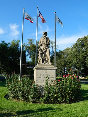
The Madonna of the Trail Statue
In 1929, the Daughters of the American Revolution placed a Madonna of the Trail statue in Upland. It is at Foothill Boulevard and Euclid Avenue. There are twelve of these statues across the country. They mark the route of the National Old Trails road. The Upland statue is the westernmost one. The statue's base mentions that Jedediah Smith passed through Upland in 1826. He led the first American group to enter California by land.
Historic Route 66 Landmarks
Even though Route 66 was officially closed in 1985, you can still see parts of it in Upland. Foothill Boulevard was once part of this famous highway. You can find a classic McDonald's with its original golden arches. There's also the vintage Buffalo Inn, which has served buffalo burgers since 1929.
Euclid Avenue's Charm
Euclid Avenue was added to the National Register of Historic Places in 2005. A 3-mile long path for horses, walking, and jogging runs down the middle of Euclid Avenue. It stretches from Foothill Boulevard to 24th Street.
Exploring Historic Downtown Upland
The oldest part of Upland is east of Euclid Avenue, between 8th Street and Arrow Highway. It was once called "Old Magnolia." Historic Downtown Upland is a group of local businesses. They work together to make the area better. Downtown Upland has almost 200 businesses. You can find many different shops, restaurants, and breweries. The Upland Farmers Market is held downtown every Saturday from April to October.
Getting Around Upland
Upland is home to Cable Airport. It is the world's largest family-owned public airport for small planes. For bigger commercial flights, you can use Ontario International Airport nearby. Los Angeles International Airport is also an option, but it's farther away.
Upland has a train station for the Metrolink commuter rail system. This system connects Upland to Los Angeles Union Station and San Bernardino. The train tracks were built in 1887. Metrolink started passenger service again in 1992. The Upland Metrolink Station is at the site of the old 1937 train station.
Euclid Avenue is part of California Highway 83. This road goes north and south, connecting to Ontario and Chino. Foothill Boulevard is part of California Highway 66. This road goes east and west and used to be part of U.S. Route 66.
Bus service in Upland is provided by Omnitrans.
Interstate 10 runs along Upland's border with Ontario. It connects Upland to Los Angeles in the west and San Bernardino in the east. State Route 210 (which will become Interstate 210) goes through northern Upland. It connects to Pasadena in the west and San Bernardino in the east.
Learning in Upland
Public Schools
Upland is served by the Upland Unified School District. Some parts of Upland are also in the Chaffey Joint Union High School District. However, none of the schools from that district are located in Upland.
High Schools
- Upland High School
- Hillside High School (a continuation school)
Middle Schools
- Pioneer Junior High School
- Upland Junior High School
Elementary Schools
- Baldy View Elementary School
- Cabrillo Elementary School
- Citrus Elementary School
- Foothill Knolls Elementary School
- Magnolia Elementary School
- Pepper Tree Elementary School
- Sierra Vista Elementary School
- Sycamore Elementary School
- Upland Elementary School
- Valencia Elementary School
Private Schools
- Carden Arbor View School (Kindergarten to 8th grade)
- Saint Mark's Episcopal School (Kindergarten to 8th grade)
- Upland Christian Academy (Kindergarten to 12th grade)
- Western Christian Schools (Pre-Kindergarten to 12th grade, with several campuses)
- St. Joseph Catholic School (Kindergarten to 8th grade)
Famous People from Upland
Born Here
- Ricky Adams, baseball player
- Aidan Apodaca, soccer player
- Kevin Ara, professional soccer player
- Jake Barrett, baseball pitcher
- Carlos Bocanegra, professional soccer player
- McKay Christensen, baseball player
- Melinda Clarke, actress
- Danielle Chuchran, actress
- Chad Cordero, baseball pitcher
- Lindsay Davis, figure skater
- Brian Dunseth, retired professional soccer player
- Aundrea Fimbres, singer and dancer
- Big B, rapper
- Jeff Kostoff, Olympic swimmer
- Eddie Lawson, motorcycle racer
- Cory Lekkerkerker, professional football player
- Litefoot, Native American rapper and actor
- Sydnee Michaels, LPGA Tour golfer
- Chad Moeller, baseball player
- Daniel Robertson, baseball player
- Joe Ruttman, race-car driver
- Alexis Serna, Canadian Football League player
- Sean Tracey, baseball pitcher
- Jason Wright, American businessman and football executive
Other Residents
- Robert Horace Baker, astronomer
- Franklin Bruno, musician
- Bill Cobbs, actor
- Alberto Dávila, boxer
- Roger Fan, actor
- Rollie Fingers, baseball player, attended Upland High School
- Red Grammer, musician
- Sandra Lee, dermatologist
- Corey Miller, tattoo artist
- Peter Popoff, televangelist
- Steve Scott, cross-country runner
- Ivan Shaw, actor
- Nedra Volz, actress
- Winds of Plague, band
- Sol Ruca, professional wrestler
Sister Cities
 Mildura, Victoria, Australia. This city was also started as an irrigation community by George and William Chaffey.
 Caborca, Sonora, Mexico.
See also
 In Spanish: Upland (California) para niños
 | Anna J. Cooper |
 | Mary McLeod Bethune |
 | Lillie Mae Bradford |


