
Urban heat island facts for kids
An urban heat island, or UHI, is when a city gets much warmer than the areas around it, like the countryside. Think of it like a "heat bubble" over a city. This happens because cities have lots of concrete, buildings, and roads. These materials absorb a lot of the sun's heat during the day and then release it slowly at night. In contrast, natural areas outside cities have more trees and plants, which help keep things cooler.
Cities can be noticeably warmer, sometimes by 1 to 6 degrees Celsius (2 to 10 degrees Fahrenheit), compared to nearby rural areas. This difference is often stronger at night and when there isn't much wind to blow the heat away.
Contents
What is an Urban Heat Island?
An urban heat island (UHI) is a city or metropolitan area that is significantly warmer than its surrounding rural areas due to human activities. The temperature difference is usually larger at night than during the day. It is also more noticeable when there is not much wind.
Why Do Cities Get Hotter?
Cities get hotter than the countryside for a few main reasons. It's all about how different surfaces absorb and release heat, and how human activities add to the warmth.
Less Water, More Heat
In natural areas, like forests or farms, a lot of the sun's energy helps water evaporate from plants and soil. This process, called evaporation, actually cools the air down, much like sweating cools your body. Cities, however, have less vegetation and open soil. This means there's less water to evaporate and cool things down. So, more of the sun's energy turns directly into heat, making city surfaces much hotter.
Buildings and Roads Absorb Heat
Most of the sun's energy in cities is absorbed by dark surfaces like asphalt roads and concrete buildings. These materials are great at soaking up heat. During the day, they get very hot. Then, they slowly release this stored heat into the air, especially at night. This keeps city temperatures high long after the sun has set.
Human Activities Add Heat
Another reason cities are warmer is the heat produced by human activities. Things like cars, buses, and trucks give off heat from their engines. Factories and industrial buildings also release a lot of warmth. Even our homes and offices add heat to the air when we use heating in winter or air conditioning in summer. All this extra heat builds up in the city, making the UHI effect stronger.
When is the Effect Strongest?
The urban heat island effect is usually strongest at night. During the day, both city and rural areas get heated by the sun. But at night, rural areas cool down faster because their natural surfaces release heat quickly. City materials, like concrete and asphalt, hold onto heat longer. This means the temperature difference between the city and the countryside becomes much bigger after dark. The effect is also stronger on calm, clear nights when there's no wind to mix the warm city air with cooler air from outside.
How Much Warmer Can Cities Be?
Cities can be quite a bit warmer than the areas around them. The temperature difference can range from 1 to 6 degrees Celsius (2 to 10 degrees Fahrenheit). In some extreme cases, especially during heatwaves, this difference can be even greater. This extra warmth can make city life uncomfortable and even dangerous during very hot weather.
Images for kids
-
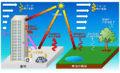
Mechanism of Urban heat island
-
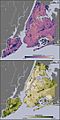
Thermal (top) and vegetation (bottom) locations around New York City via infrared satellite imagery. A comparison of the images shows that where vegetation is dense, temperatures are lower.
-
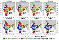
Monthly variation in day-time UHI in the pre and post-monsoon seasons. (a–d) Day-time UHI (°C) for the post monsoon season (October–January), (e–h) day-time UHI for the pre-monsoon season (February–May). All the values were estimated for LST and NDVI data from MODIS Aqua sensor. The red and blue colours indicate positive and negative values of UHI. The size of the circles represents the intensities in °C. The coloured regions show different climate zones based on Koppen Geiger climate classification map. The dominant climate regions across India is classified as: Cold Desert (CD), Warm Mediterranean (WM), Cool Continental (CC), Tropical Monsoon (TM), Tropical Savannah (TS), Warm Semi-arid (WSA), Cold Semi-arid (CSA), Warm Desert Climate (WDC), Warm Humid Subtropical (WHS), Humid Continental (HC) and Hot-Humid Subtropical (HHS).
-
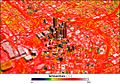
Image of Atlanta, Georgia, showing temperature distribution, with blue showing cool temperatures, red warm, and hot areas appear white.
-

Green roof of Chicago City Hall.


See also
 In Spanish: Isla de calor para niños
