
Gibraltar Dam facts for kids
Quick facts for kids Gibraltar Dam |
|
|---|---|

Bird's eye view of the dam and lower part of the reservoir
|
|
| Country | United States |
| Location | Santa Barbara County, California |
| Coordinates | 34°31′37″N 119°41′13″W / 34.52694°N 119.68694°W |
| Construction began | 1913 |
| Opening date | January 23, 1920 |
| Construction cost | $2 million (1920 dollars) |
| Owner(s) | City of Santa Barbara |
| Dam and spillways | |
| Type of dam | Concrete arch |
| Impounds | Santa Ynez River |
| Height | 194.5 ft (59.3 m) |
| Length | 600 ft (180 m) |
| Reservoir | |
| Creates | Gibraltar Reservoir |
| Total capacity | Original: 15,374 acre⋅ft (18,964,000 m3) Most recent survey (2017): 4,968 acre⋅ft (6,128,000 m3) Current (Estimate February 2019): 4,314 acre⋅ft (5,321,000 m3) |
| Catchment area | 216 sq mi (560 km2) |
| Surface area | 248 acres (100 ha) |
| Normal elevation | 1,400 ft (430 m) max |
| Power station | |
| Installed capacity | 820 KW |
| Annual generation | 1,874,000 KWh |
The Gibraltar Dam is a large dam built on the Santa Ynez River in Santa Barbara County, California, in the United States. It creates the Gibraltar Reservoir. The city of Santa Barbara owns and operates the dam.
The dam was first built in 1920 and made bigger in 1948. It is located in a quiet, natural area within the Los Padres National Forest. Its main job is to provide drinking water for Santa Barbara. It supplies almost 30% of the city's water needs each year. Water from the dam also helps power a small hydroelectric plant.
Over time, a lot of dirt and sand (called sediment) has built up in the reservoir. This has made the lake much smaller than it used to be. Sometimes, after a big storm, the lake fills up and overflows quickly. Other times, it can dry up completely. In 2019, the reservoir's capacity was only about 19% of what it was designed to hold. The dam is in a part of the Santa Ynez River known as the "Gibraltar Narrows." This area was also home to the Gibraltar mercury mine, which operated nearby for many years.
Contents
About Gibraltar Dam
Gibraltar Dam is a type of dam called a concrete arch dam. It stands about 194.5 feet (59.3 m) high and is 600 feet (180 m) long. The dam is located about 72 miles (116 km) from where the Santa Ynez River meets the ocean. It sits just above where Devils Canyon joins the river.
The dam controls water from a large area of 216 square miles (560 km2). This area collects about 24,000 acre-feet (30,000,000 m3) of water each year. Most of the land upstream is wilderness, so the water flow is natural. Another smaller dam, Juncal Dam, is also upstream. Downstream from Gibraltar Dam, the Santa Ynez River flows into a much larger lake called Lake Cachuma.
How the Spillway Works
The dam has a special section called a spillway that lets extra water flow out safely. This spillway has four gates that can be opened by hand. During dry seasons, temporary boards can be added to the top of these gates. This helps to hold more water in the reservoir. When the spillway overflows, the water creates a 150-foot (46 m) tall waterfall next to the dam.
Reservoir Capacity Changes
When it was first built, Gibraltar Reservoir could hold about 15,374 acre-feet (18,964,000 m3) of water. After it was made bigger in 1948, its total capacity increased. However, a lot of sediment had already collected, so the usable space was still around 15,000 acre-feet (19,000,000 m3). Since then, the dam has not been raised again, and the sediment has not been removed. This means the reservoir has continued to shrink. By February 2019, its capacity was only 4,314 acre-feet (5,321,000 m3).
Water Delivery System
Water is taken from the reservoir through a special opening near the dam. It then travels through the 3.7-mile (6.0 km) long Mission Tunnel. This tunnel goes under the Santa Ynez Mountains. The water then reaches a small holding basin called Lauro Reservoir. From there, the water is either cleaned at a treatment plant before going into the city's water pipes. Or, it can be released into Mission Creek to help refill underground water supplies.
At the end of the Mission Tunnel, there is a small power plant called the Lauro hydroelectric plant. It can produce 820 kilowatts of electricity. It was built in 1985 but stopped running in 1998 because it became too expensive. The city fixed it up in 2015, but a drought kept it from running until early 2017.
Building the Dam
In the early 1900s, the city of Santa Barbara needed more water. They looked to the Santa Ynez River, which had much more water than their local streams. In 1904, they started digging the Mission Tunnel. This tunnel was meant to bring water from the Santa Ynez River basin to the city. At that time, it was the longest water tunnel in the world.
The city decided to build a dam on the Santa Ynez River to get even more water for the tunnel. Between 1913 and 1919, they raised $820,000 to build the dam and water system. Several locations were considered, but Gibraltar was chosen. It offered the most storage space and the best rock for building the dam.
Challenges of Construction
Building the dam was very difficult because there was no road to the site. Workers and supplies had to travel through the Mission Tunnel on a tiny electric railway. The tunnel was only 4 feet (1.2 m) high and 3.5 feet (1.1 m) wide. This meant that large equipment, like steam shovels and concrete mixers, had to be taken apart and moved through the tunnel piece by piece.
Up to three trains ran at once, delivering supplies every half-hour. Dangerous materials like dynamite could not go through the tunnel. They had to be carried over the Santa Ynez Mountains on a rough trail. Water constantly leaked into the tunnel, making the work even harder. Special care was needed to keep this water clean, as it would eventually flow to Santa Barbara.
Despite these challenges, the dam was built quickly once work started. Cement and lumber were also brought through the tunnel. The materials for the concrete were dug from the riverbed nearby. A cable system then lifted the mixed concrete onto the dam. Work had to stop for three months during the winter of 1918-1919 because of flood risks. The dam was first built to a height of 170 feet (52 m) above the riverbed.
The Gibraltar Dam was finished on January 23, 1920. It was the first dam to hold back the Santa Ynez River. Because of how hard it was to reach the site, the dam cost almost $2,000,000 to build. When it was done, it was very accurate, with no part being off by more than one inch.
A hole was left at the bottom of the dam to let the river flow during construction. This hole was later closed, and the reservoir began to fill. The spillway was not fully finished at first. In 1922, heavy rains filled the reservoir and caused it to overflow. This damaged the temporary spillway, and it had to be rebuilt for $90,000.
Water Rights and the Law
In 1928, a farmer named Gin Chow sued the city of Santa Barbara. He owned a farm on the Santa Ynez River. He argued that the city did not have the right to take water from Gibraltar Reservoir. Soon, 39 other farmers joined his case.
Chow's argument was based on "riparian water rights." This idea meant that landowners along a river had the right to the full, natural flow of the stream through their land. It did not matter if they used the water or not. However, a new state law had just passed that year. This law said that water should be used for "beneficial use" and not wasted. The Gin Chow case was the first big legal test of this new law.
Court Decision and Impact
Five years later, in 1933, the California Supreme Court decided the case in favor of the city. The court said that the water taken by the city was "extraordinary storm waters." This meant it was floodwater that would have flowed into the ocean anyway. So, taking this water did not harm the landowners downstream.
The court's decision allowed Santa Barbara to take a certain amount of water from Gibraltar Dam each year. But it also required the city to release at least 616 acre-feet (760,000 m3) of water during the late summer and fall. This is when the river's natural flow is lowest. These rules still guide how the dam operates today.
The Gin Chow case was very important for California water law. It supported the new law about "beneficial use" of water. This reduced the power of landowners over the state's water resources. It also made it easier for cities like Santa Barbara to claim surface water, as long as they used it "reasonably." The court also said that what is "reasonable use" depends on each situation. This decision helped set a legal example for California to build more dams.
Making the Dam Bigger
Soon after it was built, the reservoir started to fill up with a lot of sediment (dirt and sand). This problem got worse when wildfires burned areas upstream. For example, the 1932 Matilija Fire burned a huge area. To help, the U.S. Forest Service built two smaller dams upstream. These "debris dams" were meant to hold back the sediment. Even though these dams collected a lot of sediment, they only helped Gibraltar Dam for a few years.
Raising the Dam in 1948
By 1948, half of Gibraltar Reservoir was filled with sediment. At the same time, a severe drought hit. The remaining water was quickly used up, and the city had to start rationing water. In the summer of 1948, the dam was made 23 feet (7.0 m) taller. A new spillway section was also added. This brought the reservoir's capacity back up to 14,000 acre-feet (17,000,000 m3) when it filled the next winter. Making the dam bigger cost $1.1 million, paid for by the city.
However, the expanded reservoir continued to fill with sediment faster than expected. Without enough storage space, the reservoir often overflows. This means the city loses water it could have used. This problem was a big reason why the federal government built Bradbury Dam in 1953. This dam created Lake Cachuma, about 25 miles (40 km) downstream, to store more Santa Ynez River water.
Earthquake Safety Upgrades
In 1983, engineers checked Gibraltar Dam for earthquake safety. They found it was at risk of failing in a strong earthquake. So, the U.S. Army Corps of Engineers strengthened the dam. They added a large concrete support to the downstream side. This project did not add more storage space to the dam. But it was designed to allow the dam to be made 20-foot (6.1 m) taller in the future if needed. This work was done in late 1990 and cost $8.18 million. It changed the dam from a simple arch dam to a stronger arch-gravity structure.
Future of the Dam

In the early 1980s, Santa Barbara wanted to raise the dam again. But state and federal agencies said that making Gibraltar Dam bigger would negatively affect water flowing into Lake Cachuma. So, in 1989, an agreement called the "Pass Through Agreement" was made. This agreement allows some water that overflows from Gibraltar Dam to be stored in Lake Cachuma for Santa Barbara's use. This meant there was no longer a need to raise Gibraltar Dam.
In 2017, experts estimated that about 210 acre-feet (260,000 m3) of sediment flows into the reservoir each year. This is about 1.3% of its original size. In recent years, the reservoir has often been very low due to droughts and high water demand. In 2016, it dried up so much that water had to be trucked to the dam keeper.
As of 2017, there are no plans to remove sediment from the reservoir or stop it from flowing in. The 1989 agreement assumes that once Gibraltar Reservoir is almost full of sediment, it will mostly just divert water. Most of its storage job will be handled by Lake Cachuma. However, some experts believe the reservoir will not completely fill with mud. They predict it will stabilize at about 2,000 acre-feet (2,500,000 m3) of water volume around 2031. This is because high water flows will help flush some of the sediment out.
Environmental Effects
When Gibraltar Dam was finished in 1920, it completely blocked steelhead fish from swimming upstream to the upper part of the Santa Ynez River. Even though a suggestion was made in 1916 to build a fish ladder (a way for fish to get around the dam), one was never built. The dam changed the river's flow, how sediment moved, and the water quality. It also made it harder for steelhead to migrate early in the rainy season.
Before the dam, there were likely many more steelhead fish. The dam did not seem to affect steelhead populations downstream much. In 1946, scientists even described the steelhead habitat below the dam as "excellent." However, steelhead could no longer reach the base of Gibraltar Dam after Bradbury Dam was built in 1953. In 2004, there was a plan to catch adult steelhead below Bradbury Dam and move them above Gibraltar Dam. This would have allowed them to complete their natural journey, but the plan was not carried out.
New Habitats and Challenges
Even though the dam caused some problems for fish, it also accidentally created new riparian habitats (areas along the river). The upstream end of Gibraltar Reservoir has slowly filled with sediment. This has created a wide, flat area with a clear stream channel. This area is now home to typical California riverside trees like willow, cottonwood, and oak. This has provided a home for endangered birds like the least Bell's vireo.
Wildfires have also affected the Gibraltar watershed. The 2007 Zaca Fire burned a large area, sending huge amounts of ash and silt into Gibraltar Reservoir. This ash reacted with chlorine in Santa Barbara's water, creating harmful chemicals. Cleaning the water cost the city almost $3 million. Other recent fires, like the 2016 Rey Fire and the 2017 Thomas Fire, have also impacted the area.
There have been worries about mercury pollution in the reservoir. This is because of the old Gibraltar Mine nearby, which closed in 1991. However, no mercury has been found in the reservoir itself. Also, there have been no cases of mercury poisoning in Santa Barbara County linked to the mine.
Visiting the Dam
The dam and reservoir are open to the public. However, only official vehicles can use the narrow, winding dirt roads that lead to the dam. The shortest way to reach the dam on foot is a 6-mile (9.7 km) round trip hike along the Santa Ynez River from Red Rock Campground. You can also get there from several trails that start at Camino Cielo Road. The Gibraltar Trail follows the southern edge of the reservoir from the dam. Other trails branch off around the reservoir into the wilderness of Los Padres National Forest. For safety and to keep the water clean, boating, fishing, and swimming are not allowed at the reservoir.
Images for kids
-

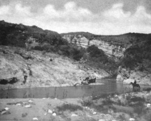
The Santa Ynez River at the Gibraltar dam site, before the dam was built.
-
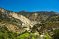
Gibraltar Dam, viewed from downstream
