Gaviota Peak facts for kids
Quick facts for kids Gaviota Peak |
|
|---|---|

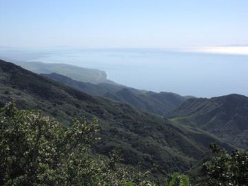
View from Gaviota Peak, looking southeast
|
|
| Highest point | |
| Elevation | 2,460 ft (750 m) NAVD 88 |
| Prominence | 198 ft (60 m) |
| Naming | |
| English translation | Seagull Peak |
| Language of name | Spanish |
| Geography | |
| Parent range | Santa Ynez Mountains |
| Topo map | USGS Solvang |
| Climbing | |
| Easiest route | Hike |
Gaviota Peak is a cool mountain top in the Santa Ynez Mountains. You can find it in Santa Barbara County, California. This peak is about 10 miles (16 km) west of Santa Barbara. It's also only 2 miles (3.2 km) from the Pacific Ocean!
Contents
What is Gaviota Peak?
Gaviota Peak is a high point in the Santa Ynez Mountains. It stands tall at 2,460 feet (750 meters) above sea level. The name "Gaviota" means "Seagull" in Spanish. This mountain offers amazing views of the surrounding area.
Hiking to the Top
One of the best ways to experience Gaviota Peak is by hiking. The main trail is called the Gaviota Peak Fire Road. It starts near where two big roads meet: U.S. Route 101 and California State Route 1.
The Trail's Journey
The trail begins in Gaviota State Park. It then goes all the way up to the summit, which is inside the Los Padres National Forest. Along the way, you'll pass by the Gaviota Hot Springs. These are natural warm pools of water.
Amazing Views from the Peak
As you hike, you'll see incredible sights. You can look out over the Santa Ynez Mountains themselves. You'll also spot the wide Lompoc Valley. On a clear day, you can see the huge Pacific Ocean. You might even catch a glimpse of the Channel Islands far off in the distance!
The Gaviota Area
The area around Gaviota Peak is quite special. The "Gaviota Grade" is a part of U.S. Route 101. It's known for being a long and steep section of the highway. This makes driving through the area an interesting experience. The peak is a popular spot for outdoor adventures.
 | Roy Wilkins |
 | John Lewis |
 | Linda Carol Brown |


