
Cold Spring Canyon Arch Bridge facts for kids
Quick facts for kids Cold Spring Canyon Arch Bridge |
|
|---|---|
 |
|
| Coordinates | 34°31′33.81″N 119°50′4.53″W / 34.5260583°N 119.8345917°W |
| Carries | 2 lanes of |
| Crosses | Cold Spring Canyon |
| Locale | Santa Ynez Mountains, Santa Barbara County, California |
| Maintained by | Caltrans |
| Characteristics | |
| Design | steel arch |
| Total length | 1,217 ft (371 m) |
| Longest span | 700 ft (213 m) |
| Clearance below | 400 ft (122 m) |
| History | |
| Construction cost | Over $2,000,000 |
| Opened | 1964 |
The Cold Spring Canyon Arch Bridge is a really cool bridge in the Santa Ynez Mountains in California. It helps connect the cities of Santa Barbara, California and Santa Ynez, California. You can find it along State Route 154.
This bridge is super special because it's the highest arch bridge in California! It's also one of the tallest bridges in the whole United States. Imagine standing on it: the bridge deck is about 400 ft (122 m) (that's like 40 stories high!) above the bottom of the canyon. It's also the biggest steel arch bridge in California. People think it's so important that it's considered a historic place.
Building the Cold Spring Canyon Arch Bridge
The bridge you see today was finished and opened in February 1964. It was built by some big companies, including American Bridge and Massman Construction Co.
This bridge was so well-designed that it won awards! It was recognized for its great engineering, its beautiful look, and how well it was built. For many years, it was one of the top five longest "supported deck" arch bridges in the world.
Cool Facts About the Bridge
Near the bridge, there's a historic place called Cold Spring Tavern. This tavern used to be a stop for stagecoaches a long time ago. It's about 600 meters south of the bridge, down in the canyon.
In 1998, the bridge got some important updates. These updates helped make it stronger and safer, especially in case of earthquakes. This work was done by American Bridge, one of the companies that helped build it originally.
Gallery
-
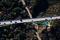
This is a view of the bridge from above. You can see Cold Spring Tavern on Stagecoach Road below the bridge.
-
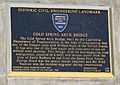
This plaque shows that the bridge is a Historic Civil Engineering Landmark.
-

Another view of the Cold Spring Canyon Bridge.


