Painted Cave, California facts for kids
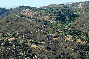
Painted Cave is a small community in Santa Barbara County. It's not officially a city, but a group of homes located high up in the Santa Ynez Mountains. The community gets its name from the nearby Painted Cave State Historic Park.
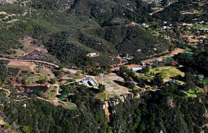
You can reach Painted Cave by Camino Cielo Road and California State Route 154. These roads connect the community to the Santa Ynez Valley and the city of Santa Barbara, California. About 100 homes are in the main area, with more scattered around.
Painted Cave is the highest and largest community within the Santa Ynez Mountains. It offers amazing views! On clear days, you can often see all eight of the Channel Islands. The homes are built on a hilly plateau, and some are very close to steep cliffs. The area also includes a large property called Laurel Springs Ranch.
Contents
History of Painted Cave
How the Community Grew
Painted Cave slowly grew over time with different kinds of buildings. You could find simple cabins and also large, fancy homes like Knapp's Castle. A big reason for its growth was when the road to the Painted Cave State Historic Park (Painted Cave Road) connected with Camino Cielo Road. This made it easier to get to the area.
Wildfires and Safety
Even though there have been many close calls and times when people had to leave their homes, Painted Cave has never been completely destroyed by a wildfire. The 1964 Coyote Fire came very close. It burned eight homes but spared the community when the wind suddenly changed direction.
Fighting Wildfires
The Painted Cave Fire
The 1990 Painted Cave Fire was named after the place where it started, not the community itself. This fire mostly moved downhill and didn't directly threaten the homes in Painted Cave. However, it did burn some of the outlying areas.
Protecting the Community
Other fires, like the Gap Fire and Jesusita Fire in 2009, also burned near Painted Cave. But the community is often surrounded by roads. These roads are helpful because they can be used to bring in supplies and also act as firebreaks (areas cleared to stop a fire from spreading). This makes Painted Cave a relatively easy place to defend during a fire. Because of this, it's often used as a command center and a place for helitack (helicopters that fight fires) during wildfires in Santa Barbara.
How Painted Cave is Managed
Local Organizations
The Wildlands Resident's Association helps with planning and getting ready for emergencies in the area. They also work with Santa Barbara County and CAL FIRE (California Department of Forestry and Fire Protection).
Several local groups manage the day-to-day things in Painted Cave. These include the Painted Cave Volunteer Fire Department and the Painted Cave Mutual Water Company.
Volunteer Fire Department
The Painted Cave Volunteer Fire Department started in 1965. They are a group of volunteers who help fight fires. They have special "Type 3" four-wheel-drive brush trucks. These trucks can go off-road to fight wildfires in wildland areas. They also have a truck that carries fire retardant gel, a recovery vehicle, and command vehicles.
Water Supply
The Painted Cave Mutual Water Company is in charge of the community's water. They pump water from the nearby Maria Ygnacio Creek into a tank system that supplies water to all the homes.
Local Representation
For government matters, Painted Cave is part of specific areas. In the California State Assembly, it's in the 37th district. In the United States House of Representatives, it's in the 24th district.
 | Delilah Pierce |
 | Gordon Parks |
 | Augusta Savage |
 | Charles Ethan Porter |


