Sespe Creek facts for kids
Quick facts for kids Sespe Creek |
|
|---|---|

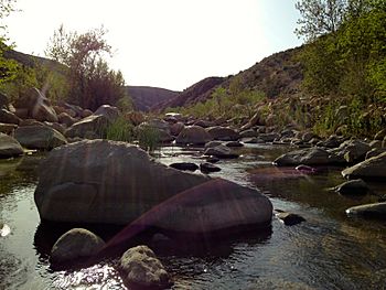
Sespe Creek flowing through the Sespe Wilderness
|
|

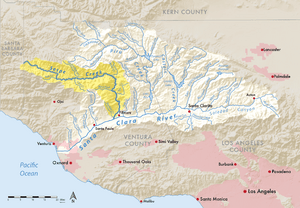
Map showing Sespe Creek highlighted in the Santa Clara River watershed
|
|
| Other name(s) | Arroyo Sespe, Cespai River, Sespe River |
| Country | United States |
| State | California |
| Region | Ventura County |
| Physical characteristics | |
| Main source | San Emigdio Mountains Potrero Seco Campground, Los Padres National Forest, California, United States 5,280 ft (1,610 m) 34°37′37″N 119°26′31″W / 34.62694°N 119.44194°W |
| River mouth | Confluence with the Santa Clara River Sespe, California and Fillmore, California, Ventura County, California 355 ft (108 m) 34°22′48″N 118°57′17″W / 34.38000°N 118.95472°W |
| Length | 61 mi (98 km) |
| Basin features | |
| Basin size | 260 sq mi (670 km2) |
| Tributaries |
|
| Type: | Wild, Scenic |
| Designated: | June 19, 1992 |
Sespe Creek is a stream in Ventura County, southern California. It is about 61 miles (98 km) (98 km) long. The creek starts in the Sierra Madre Mountains and flows into the Santa Clara River near Fillmore. More than 30 smaller streams feed into Sespe Creek.
A large part of Sespe Creek, about 31 miles (50 km) (50 km), is called a National Wild and Scenic River. This means it is protected and does not have any dams or concrete channels. It is one of the last natural rivers in Southern California. Most of the creek flows through the Los Padres National Forest.
The name Sespe comes from a Chumash Indian village. The village was called Cepsey, Sek-pe, or S'eqpe' in the Chumash language. This name means "Kneecap." The village was mentioned in 1791. Later, a Mexican land grant in 1833 was named Rancho Sespe.
What is the Sespe Creek Watershed?
A watershed is an area of land where all the water drains into one main river or stream. The Sespe Creek watershed is special because it has not been changed much by people. There are no large dams on the creek. One dam was planned near Sespe Hot Springs, but it was never built.
The creek begins high up in the Sierra Madre Mountains, over 5,000 feet (1,500 m) (1,500 m) high. About 75% of the Sespe Creek area has rugged slopes and canyon walls. The creek does not always flow with water, but it has many deep pools that stay full year-round.
How Does Sespe Creek Get Its Water?
Many smaller streams and springs feed into Sespe Creek. Some of the main ones are Lion Canyon, Hot Springs Canyon, Timber Creek, West Fork Sespe Creek, and Little Sespe Creek. The creek gets most of its rain between January and April. Sespe Creek provides about 40% of the water that flows into the Santa Clara River.
Protecting Sespe Creek's Natural Beauty
Much of Sespe Creek is protected inside the Los Padres National Forest. The Sespe Wilderness Area covers about 219,700-acre (889 km2) (889 sq km). This area includes 31.5 miles (50.7 km) of Sespe Creek. It was created in 1992.
Inside the Wilderness Area is the 53,000-acre (210 km2) (214 sq km) Sespe Condor Sanctuary. This sanctuary helps protect the California condor. About 10.5 miles (16.9 km) of the upper Sespe Creek are designated as "wild and scenic." Also, the creek is a "wild trout stream" from the Lion Camp area down to the edge of the Los Padres National Forest.
Animals and Plants of Sespe Creek
The Sespe Creek flows through different natural areas. These include California montane chaparral and woodlands and riparian woodlands. Riparian woodlands are forests found along rivers and streams.
It is hard to reach some parts of Sespe Creek. This is because of the deep canyons and sudden floods that make roads difficult to maintain. This inaccessibility has made the area a safe place for many animals. Some of these animals have disappeared from other parts of southern California.
Rare and Endangered Species in Sespe Creek
The Sespe Creek area is a refuge for several important species. These include the California condor and the southern steelhead trout. It may also be home to the California golden beaver. The California grizzly bear lived in the Sespe area until at least 1905.
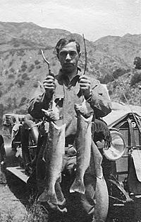
The Sespe is one of the last southern Steelhead trout streams in southern California that flows freely.

The place where Sespe Creek meets the Santa Clara River is important for several endangered species. It helps them move between different areas. These species include:
The Sespe Creek area has the largest known population of the arroyo toad.
California Condor: A Protected Bird
The Sespe Creek watershed is home to the 53,000-acre (210 km2) (214 sq km) Sespe Condor Sanctuary. This sanctuary was created in 1947. It protects the wild home of the California condor (Gymnogyps californianus). This bird is a critically endangered species.
California Golden Beaver: A Return to the Wild?
In 1906, a male California golden beaver (Castor canadensis subauratus) was found "wild caught" along the Sespe River. This shows that golden beavers used to live in coastal streams in southern California. The skull of this beaver is kept at the Museum of Vertebrate Zoology in Berkeley, California.
Even though beavers were later brought back to California starting in 1923, this 1906 finding proves they were there before.
Historical Evidence of Beavers
Chumash people who lived in the area long ago also spoke about beavers. Their stories say that beavers lived in the Santa Clara River until Europeans arrived.
One Chumash story says: "The beaver comes and gnaws the tree on the side towards which it leans, and at last falls over. The tree is leaning towards our house. I am beginning to fear that it will fall on us. The beaver builds its house in the river or the cienegas in the time of our ancestors. There were beavers at Ventura and also at Saticoy."
There is also a Chumash drawing of a beaver at Painted Rock. This rock is in the Cuyama River watershed, about 35 miles (56 km) (56 km) from where Sespe Creek starts.
The Hearst Museum in Berkeley has a Chumash shaman's rain-making kit. It is made from a beaver tail skin and a tobacco sack. The shaman, "Somik," made it in the 1870s.
Chumash people also believed that a willow stick cut by a beaver could bring water. They would treat the stick and plant it to create a permanent spring. The Barbareño and Ventureño Chumash even had a Beaver Dance. The Chumash word for beaver is Chipik. All these facts suggest that beavers lived throughout Santa Barbara County, California and Ventura County, California.
There is a Beaver Campground on Sespe Creek. People have seen beavers, their dams, and lodges there. Andy Bisaccia saw them between 1938 and 1944. A USFS Fire Crew Chief, James Jeffery, saw beaver dams above Beaver Camp in 1969-1970. Another person, Alasdair Coyne, saw a beaver dam at Willett Hot Springs in 2000.
|
 | Sharif Bey |
 | Hale Woodruff |
 | Richmond Barthé |
 | Purvis Young |


