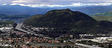
Conejo Mountain facts for kids
Quick facts for kids Conejo Mountain |
|
|---|---|

Conejo Grade cuts through the Conejo Hills.
|
|
| Highest point | |
| Elevation | 1,814 ft (553 m) |
| Geography | |
| Location | Camarillo, California |
| Topo map | Camarillo East |
Conejo Mountain is a mountain in Ventura County, California. It stands about 1,814-foot-high (553 m). The mountain is located near Camarillo. It sits on the eastern edge of the Oxnard Plain. It is also next to the Santa Monica Mountains. A major road, U.S. Route 101, crosses through this area. This part of the road is known as the Conejo Grade. It was once a very tough path for travelers.
Contents
Conejo Mountain: A Look at Its Past
Conejo Mountain has an exciting history. Millions of years ago, it was a large volcano. This volcano was active about 14 million years ago. Today, it is no longer active. We call it an extinct volcano. At one point in time, the mountain was even under the sea.
What is Conejo Mountain Made Of?
Since 1959, people have been mining on Conejo Mountain. Mining means digging up valuable rocks or minerals. Most of the mountain is owned by a company called Pacific Rock. They use the mountain for their mining work.
Protecting Conejo Mountain's Nature
Many groups want to protect Conejo Mountain. They want to keep it as protected open space. This means the land would be saved for nature and public use. These groups include:
- The Santa Monica Mountains Conservancy
- The Pleasant Valley Recreation and Park District
- The Conejo Open Space Conservation Agency
Exploring the Mountain: Trails and Parks
You can explore parts of Conejo Mountain. There are trails that lead into the area. These trails start from nearby parks.
- One starting point is Pepper Tree Playfield.
- Another is Dos Vientos Community Park.
- These trails go through the Dos Vientos Open Space. This open space is in southwestern Newbury Park.
 | Bessie Coleman |
 | Spann Watson |
 | Jill E. Brown |
 | Sherman W. White |

