
Mount Tallac facts for kids
Quick facts for kids Mount Tallac |
|
|---|---|
 |
|
| Highest point | |
| Elevation | 9,739 ft (2,968 m) NAVD 88 |
| Prominence | 695 ft (212 m) |
| Listing | Tahoe OGUL Peak List Sierra Peaks Section |
| Geography | |
| Location | El Dorado County, California, U.S. |
| Parent range | Sierra Nevada |
| Topo map | USGS Emerald Bay |
| Climbing | |
| Easiest route | Trail hike, class 1-2 |
Mount Tallac is a tall mountain peak. It is located southwest of Lake Tahoe in El Dorado County, California. This mountain is part of the Desolation Wilderness area. It is also found within the Eldorado National Forest.
You can easily see Mount Tallac from several major roads. These include State Route 89, State Route 28, and U.S. Route 50. A special "cross of snow" often appears on the mountain's side. This cross is visible in winter, spring, and early summer.
Contents
What's in a Name?
Mount Tallac has had different names over time. Early maps from the Whitney Survey called it Chrystal Peak.
Later, in 1877, the Wheeler Survey officially named it "Tallac." This name comes from the Washo word "daláʔak." In the Washo language, "daláʔak" means 'big mountain.'
Hiking Mount Tallac
Mount Tallac is a popular spot for hikers. About 10,000 people climb this peak every year. There are several ways to reach the top. Some trails start from the Desolation Wilderness to the west. Others begin near Fallen Leaf Lake to the east. You can also use access roads from the north.
Do You Need a Permit to Hike?
Yes, you need a special permit to hike Mount Tallac. This is because it is located inside the Desolation Wilderness.
For day hikes, permits are free. You can get them yourself at the trailhead. If you plan to stay overnight, there is a limit on how many people can be on the mountain. However, there is no limit for day hikers.
Mount Tallac in Pop Culture
Mount Tallac has even appeared on TV! The very first scenes of the classic TV show Bonanza were filmed here. The show used the beautiful McFaul Creek Meadow. Mount Tallac was clearly visible in the background.
Images for kids
-
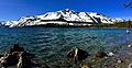
Fallen Leaf Lake and Mount Tallac

