
Sutter Buttes facts for kids
Quick facts for kids Sutter Buttes |
|
|---|---|

Bird's eye view of the Sutter Buttes, rising over the town of Yuba City, California
|
|
| Highest point | |
| Elevation | 2,122 ft (647 m) |
| Listing | California county high pt 56th |
| Geography | |

Location in California
|
|
| Country | United States |
| State | California |
| Region | Sacramento Valley |
| District | Sutter County |
| Range coordinates | 39°13′35″N 121°48′38″W / 39.22639°N 121.81056°W |
| Topo map | USGS Sutter Buttes |
| Geology | |
| Type of rock | volcanic neck |


The Sutter Buttes are a small group of hills in Sutter County, Northern California. They are sometimes called the world's smallest mountain range. These hills are actually the remains of an old volcano. They stand out from the flat land of the Sacramento Valley. You can find them near Yuba City.
The highest point in the Sutter Buttes is South Butte. It reaches about 2,122 ft (647 m) high. This makes it the highest spot in Sutter County. The small town of Sutter is located at the base of these hills. Both the town and the buttes are named after John Sutter. He was given a large piece of land in the area by the Mexican government long ago.
Contents
Geography
The Sutter Buttes form a rough circle. They are about 10 mi (16 km) wide from north to south and east to west.
How the Sutter Buttes Formed
The Sutter Buttes are located within the Central Valley of California. They were created about 1.6 million years ago. This happened during a time called the early Pleistocene Epoch. They are what is left of a volcano that has been sleeping for about 1.4 million years.
Some scientists think this volcano might be the most southern part of the Cascade Volcanic Arc. However, it is quite different from other volcanoes in that group. Other scientists believe it is more like the volcanoes found in the California Coast Ranges. Even then, it still has some unique features.
People first looked for natural gas here in 1864. A man named Dexter Cook dug a 65 ft (20 m) hole. Later, in 1927, a company drilled a deeper well. In 1935, they found natural gas and drilled more wells.
Soils and Plants
The middle part of the Buttes is rocky. It has brown, sandy soil that drains water well. The flatter edges have different kinds of soil, including clay and silt. These soils help support different types of plants. You can find grasslands and oak woodlands here.
The Sutter Buttes are home to many different species of plants and animals. Many kinds of wildflowers grow here. One special wildflower is the yellow mariposa lily, also known as Calochortus luteus.
History


Native American History
The Sutter Buttes are very important in the stories of the Native American Maidu and Wintun peoples. The Nisenan Maidu lived on the east side of the Buttes. The Patwin Wintun lived on the west side. The Maidu call the Sutter Buttes Histum Yani or Esto Yamani. The Wintun name is Onolai-Tol. All these names mean something like "The Middle Mountains."
These tribes did not live in the buttes all year. But they visited often to gather acorns and other foods. They also hunted animals. The Buttes were also a key place for Native American religious practices. A religion called the Kuksu Cult started near here. This religion spread across much of northern California. People would perform ceremonies in special lodges. They would act out old stories and myths.
In the Maidu religion, the Sutter Buttes was a place where people went after they died to reach the afterlife.
Later History in California
The first European to see the Sutter Buttes was Gabriel Moraga in 1806. In 1817, Luis Antonio Argüello called them "los tres picos" (the three peaks). This name appeared on the land grant given to Captain John Sutter. In 1843, John C. Frémont called them "The Three Buttes."
During the California Gold Rush, the Buttes were known as Marysville Buttes. In 1920, the state of California tried to buy the Marysville Buttes but could not. Finally, in 1949, they officially became known as the Sutter Buttes.
In 2003, the California Department of Parks and Recreation bought about 1,784.5 acres (7.222 km2) of land in Peace Valley. This land is on the north side of the Sutter Buttes. They wanted to make it a state park. However, this land does not have public access. As of 2017, the park is still closed to the public. The only way to reach it is a narrow path that crosses private land. This path is not suitable for public use.
Titan Missile Silos and U-2 Crash
Between 1960 and 1962, the US Air Force built a Titan 1 missile launch site here. It was called the Pennington Missile Base. This site was part of a larger squadron based at Beale Air Force Base. The Titan 1 sites were very strong. They were designed to survive a nuclear attack. Each site had three underground missile silos. These silos were connected to bunkers by tunnels.
The facility was used from 1962 to 1965. In January 1965, the Titan 1 missiles were taken out of service. All missiles were removed by February 1965. The land was then sold back to private owners.
In September 2016, a US Air Force Lockheed U-2 spy plane crashed in the Sutter Buttes. This happened during a training flight. One of the two pilots died in the crash.
Public Access
Before 1960, the land was private but people could visit it. In 1960, a fire spread on the Buttes. After that, the ranchers decided to close the area to the public. The state wants to open some parts of the Buttes for public access again. However, the nearby ranchers are not happy about this idea.
Most of the land in the Sutter Buttes is privately owned by ranchers and farmers. But there is one important exception. A 200 acres (0.81 km2) piece of land on North Butte was given to the Sutter Buttes Regional Land Trust. This land was given on the condition that it would be used for supervised public education. It is not for private use. If these rules are broken, the land can go back to its original owner.
A few groups, like Middle Mountain Interpretive Hikes and the Sutter County Historical Society, lead guided walks through some areas. This allows people to learn about the nature and history of the Buttes.
Gallery
-
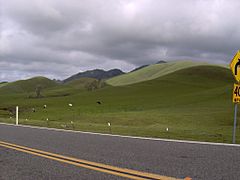
Sutter Buttes, 2006.
-
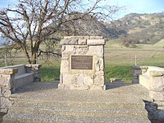
A monument at the base of the mountains indicating that John C. Fremont camped near here.
-
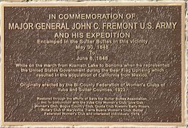
A close up of the inscription on the memorial.
-
The Tiki.
-
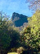
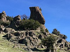
Rock of Gibraltar, Sutter Buttes, California.
-
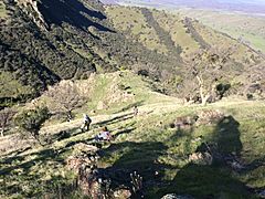
High transect hikers resting while ascending a slope in the Sutter Buttes, California.


See also
 In Spanish: Sutter Buttes para niños
