Junipero Serra Peak facts for kids
Quick facts for kids Junipero Serra Peak |
|
|---|---|

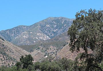
Junipero Serra Peak in 2015
|
|
| Highest point | |
| Elevation | 5,857 ft (1,785 m) NAVD 88 |
| Prominence | 4,447 ft (1,355 m) |
| Listing |
|
| Geography | |
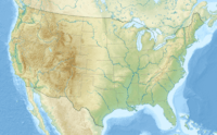
| Location | Monterey County, California, U.S. |
| Parent range | Santa Lucia Mountains |
| Topo map | Junipero Serra Peak |
| Climbing | |
| Easiest route | Trail |
Junipero Serra Peak is the tallest mountain in the Santa Lucia Mountains of central California. It is also the highest point in Monterey County. This peak is named after Junípero Serra, a Spanish priest from the 1700s. He was famous for starting the California Missions.
How the Peak Got Its Name
This mountain was first called Santa Lucia Peak. This was because it is the highest point in the Santa Lucia mountain range.
In 1905, a group called the Native Daughters of the Golden West wanted to honor Junípero Serra. They first named a different peak in the Sierra Nevada mountains after him.
However, the Sierra Club suggested that the name should be moved to Santa Lucia Peak instead. The United States Board on Geographic Names agreed in 1906. They decided that Junípero Serra knew the Santa Lucia Mountains well. But he probably never visited the Sierra Nevada mountains.
The peak also has an older name, Pimkolam. This is its ancient name from the Salinan Native American people.
Weather at the Top
Junipero Serra Peak is over 5,000 feet (about 1,500 meters) high. Because it's so high, the temperatures in winter get very cold. This means the peak often gets snow. It also receives a lot more rain and snow compared to nearby areas. For example, the Salinas Valley and places further east get much less precipitation.
The 2008 Indians Fire
In 2008, a large wildfire called the Indians Fire burned a lot of the area. This included Junipero Serra Peak and much of the southern Ventana Wilderness.
 | Kyle Baker |
 | Joseph Yoakum |
 | Laura Wheeler Waring |
 | Henry Ossawa Tanner |


