Cone Peak facts for kids
Quick facts for kids Cone Peak |
|
|---|---|

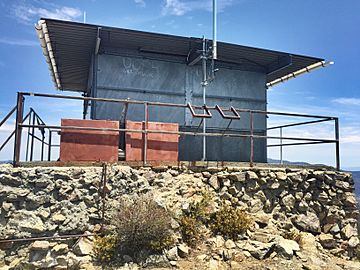
Decommissioned forest fire lookout on Cone Peak
|
|
| Highest point | |
| Elevation | 5,155 ft (1,571 m) NAVD 88 |
| Prominence | 2,915 ft (888 m) |
| Geography | |
| Parent range | Santa Lucia Mountains |
| Topo map | USGS Cone Peak |
| Climbing | |
| Easiest route | Road and trail hike |
Cone Peak is a tall mountain in California. It's the second highest peak in the Santa Lucia Range. This mountain is special because it rises almost a mile straight up from the Pacific Ocean! It's one of the steepest climbs from the ocean to a summit in the United States. The top of the mountain is about 5,155 feet (1,571 meters) high.
About Cone Peak
Cone Peak is part of the Ventana Wilderness in the Los Padres National Forest. It stands very close to the coast, only about 3 miles away. This makes its slopes incredibly steep. As you climb higher on the mountain, the trees change. You'll see oak trees and chaparral plants, which then turn into a pine forest. Some very rare Santa Lucia fir trees also grow near the top. The highest peak in this coastal area is Junipero Serra Peak, which is even taller at 5,865 feet (1,788 meters).
Getting There
Cone Peak is a popular spot for hiking. You can reach it by driving on the Nacimiento-Fergusson Road. Then, you turn onto Forest Route 22S05 for about 6 miles. This road, called the Coast Ridge Road, goes up to about 3,800 feet (1,158 meters). From there, it's a 2.25-mile hike along the Cone Peak Trail to the very top. There are also two trails that start from the coast and go all the way to the summit: the Stone Ridge/Gamboa Trail and the Vicente Flat Trail.
The Fire Lookout
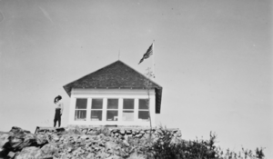
At the very top of Cone Peak, there's an old fire lookout building. It was built in 1923 to help spot forest fires. The original building was made of wood and had a special "dunce cap" roof. Workers had to bring all the building pieces up the steep, narrow 2-mile trail using mules!
During World War II, this lookout was used as an observation post. People watched for enemy aircraft from here. In 1959, the U.S. Forest Service changed the lookout. They replaced the old roof with a flat one so that a helicopter could land on it. They also changed the wood walls to metal. This helped protect the building from fires and damage. The lookout was last used by staff in 1990. Today, it holds radio repeater equipment, so it's not easy to use it as a fire tower anymore.
The Cone Peak lookout was one of six active fire lookouts in the Monterey Ranger District. The others were on Chews Ridge, Ventana Double Cone, Junipero Serra Peak, Pinyon Peak, and Three Peaks.
Special Trees
The slopes of Cone Peak are home to some amazing trees. You can find old Sugar pine trees here. There are also many groups of Santa Lucia fir trees. These fir trees are very rare and are found almost nowhere else in North America, or even the world! Many famous plant scientists, called botanists, visited Cone Peak long ago to study these unique trees. Some of these visitors included David Douglas in 1831, Thomas Coulter in 1832 or 1833, Karl Theodor Hartweg in 1947, and William Lobb in 1849.
 | Precious Adams |
 | Lauren Anderson |
 | Janet Collins |


