
Chews Ridge Lookout facts for kids
Quick facts for kids Chews Ridge Lookout |
|
|---|---|

Mary and Arthur Story standing on the deck of the Chew's Ridge Lookout Station in 1929
|
|
| General information | |
| Type | Fire lookout tower |
| Location | Los Padres National Forest |
| Coordinates | 36°18′43″N 121°34′06″W / 36.3120°N 121.568330°W |
| Construction started | 1929 |
| Completed | 1929 |
| Height | 24 feet (7.3 m) |
| Technical details | |
| Structural system | Steel |
The Chews Ridge Lookout is a special tower used to spot wildfires. It's located in the Los Padres National Forest, about 50 miles (80 km) southeast of Monterey. The tower you see today was built in 1929. People worked there until about 1990.
In 2019, a group of volunteers started staffing the tower again. They help keep an eye out for fires. The lookout and the ridge it sits on are named after Constantine and Nellie Chew. They were early settlers who owned land here in the late 1800s. You can reach the lookout by driving on Carmel Valley Road and then Forest Route 18S02/Tassajara Road for about 9 miles (14 km). Parts of this road are unpaved and can be rough, so a strong car is often needed.
Contents
What is the Chews Ridge Lookout?
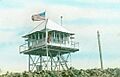
In 1919, a family lived in a small cabin at the top of the ridge. This cabin also served as an early fire lookout. The current steel tower was built in 1929. It stands 24 feet (7.3 m) tall and has a 13 by 13 feet (4.0 m × 4.0 m) room at the top. The tower is very high up, at an elevation of 5,082 feet (1,549 m). Arthur Story and his wife were some of the first people to live and work at the lookout.
The lookout was damaged by a big fire called the Marble Cone Fire in 1977. It was rebuilt in 1978. In 1984, the top room was replaced with a new design that included a walkway around it and a flat roof.
Life at the Lookout
To get into the tower's top room, you have to climb a steep staircase with narrow steps. There is no running water, electricity, or air conditioning inside. Also, there's no cell phone service or internet on Chews Ridge. People working there use a special battery-powered U.S. Forest Service radio to communicate.
From the 1940s to the 1950s, C. C. Yates and his wife worked at the tower during fire season. The U.S. Forest Service stopped staffing the tower around 1990. After that, the tower was used for radio equipment and antennas.
Volunteers Keep Watch
In 2019, a group called the California-South Chapter of the Forest Fire Lookout Association made a deal with the U.S. Forest Service. They started using volunteers to staff the tower. These volunteers cleaned up the cabin and fixed the special tool used to find fires, called an Osborne Fire Finder.
The Forest Fire Lookout Association trains volunteers to be fire lookouts. They started working at the tower in August 2019. Their goal is to have people watching for fires seven days a week from May through November.
Chews Ridge Lookout was one of six active fire lookouts in the area. The others were on Cone Peak, Ventana Double Cone, Junipero Serra Peak, Pinyon Peak, and Three Peaks.
History of Chews Ridge
Early People of the Ridge
Before European settlers arrived, the Esselen people lived in the Chews Ridge area. They left unique handprints on cave walls south of the ridge. You can also find evidence of their presence, like special grinding holes in rocks, near areas with Valley Oak trees.
Ranching Life
One of the first non-native Americans to explore the ridge was William Brewer in 1861. Chews Ridge is named after Constantine Marcus and Eleanor "Nellie" (James) Chew. They got married in 1881 and claimed two pieces of land, 155 acres (63 ha) and 160 acres (65 ha), on the ridge in the 1880s and 1890s. This was about four miles south of Jamesburg.
Eleanor Chew was the postmaster for Jamesburg from 1894 to 1919. She also wrote a local news column for newspapers for 25 years. In 1906, she reported that the first car ever tried to drive up the steep road above Jamesburg. Daily car service to and from Salinas started in 1914. Nellie Chew also became the librarian for the Jamesburg branch of the Monterey County Library.
The Chews sold their ranch in 1919. Constantine Chew passed away in 1920, and Eleanor died in 1952.
World War II Efforts
During World War II, the lookout was used by civilian observers. They were part of the Aircraft Warning Service. Their job was to watch for enemy planes. Extra housing was built for these observers, who worked around the clock.
China Camp Campground
| China Camp | |
|---|---|
| Location | Monterey County, California, United States |
| Elevation | 4,260 ft (1,300 m) |
| Type | Drive In |
| Land | Los Padres National Forest |
| Campsites | 10 |
| Facilities | Two vault toilets, picnic tables |
| Water | No |
| Fee | $20/night |
| Fires | Yes |
China Camp is a public campground near the top of Chews Ridge. It's the starting point for the Pine Ridge Trail. There are modern toilets, but no water is available.
There are 10 campsites you can reserve. Some are open all year, and others are only open in the summer. It costs $20 per night for one vehicle. The road to China Camp can be rough, especially in winter. It continues over the mountain for 7.9 miles (12.7 km) on a very narrow, steep dirt road to Tassajara Hot Springs. Chews Ridge is the only high peak in the Santa Lucia Range with a road crossing its summit.
China Camp got its name from the Chinese workers. They lived at the camp while building the road to the Tassajara Hot Springs Resort in 1888.
Fires and Nature
Fire History
Fires have been a part of Chews Ridge's history for a long time. In 1903, a fire started by an unextinguished campfire burned for three months. It created a path 6 miles (9.7 km) wide to the coast. Eleanor Chew wrote about the smoke and how men were fighting the fire.
In 1906, another large fire burned 150,000 acres (61,000 ha) over 35 days. It was finally put out by the first rain of the season. In 2017, the Soberanes fire reached Chews Ridge. Firefighters had to set controlled fires to stop it from spreading further.
Plants and Rocks
The slopes of Chews Ridge have a forest with different types of trees. These include Valley Oak (Quercus lobata) and Coulter pine (Pinus coulteri). The ridge also has open grassy areas with many large valley oaks. The main types of rocks found here are schist, ultrabasic rocks, and sandstone.
Weather on the Ridge
Chews Ridge is 5,082 feet (1,549 m) high, making it the third highest peak in the Santa Lucia Range. Junipero Serra Peak is the highest at 5,865 feet (1,788 m). During big winter storms, the peak can get 1 to 2 feet (0.30 to 0.61 m) of snow. In 1907, Eleanor Chew reported that 9 feet (2.7 m) of snow had fallen on the ridge!
Astronomy at Chews Ridge
Students studying astronomy from Case Western Reserve University wanted to build their own observatory. They found a large 36 inches (910 mm) mirror at Princeton that they could borrow. They looked for mountains along the west coast where the air was clear and steady for viewing stars. They chose the Santa Lucia Range.
In 1972, members of the Monterey Institute for Research in Astronomy asked the Forest Service for permission to build. They got it in 1974. The students moved to Monterey County and worked part-time jobs. This helped them buy 80 acres (32 ha) of land nearby. In 1975, the Army Corps of Engineers finished the last half-mile of road to the observatory. Famous astronomers Bart Bok and his wife Priscilla donated their collection of science books.
The Oliver Observing Station (36°18′20″N 121°34′00″W / 36.30556°N 121.56667°W) was built about .6 miles (0.97 km) south-southeast of the lookout. When it opened in 1982, it was the first private observatory to open in the United States in the 20th century.
Images for kids
-
Color slide of Chews Ridge Lookout circa 1934

