Nacimiento River facts for kids
Quick facts for kids Nacimiento River |
|
|---|---|

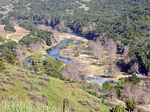
The river downstream of Nacimiento Dam
|
|

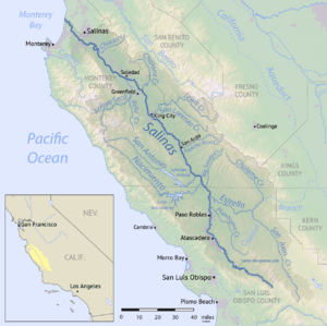
Map of the Salinas River watershed including the Nacimiento River
|
|
| Other name(s) | Spanish: Río Nacimiento |
| Country | United States |
| State | California |
| Physical characteristics | |
| Main source | Unnamed spring Santa Lucia Mountains, San Luis Obispo County 3,280 ft (1,000 m) 36°01′55″N 121°28′21″W / 36.03194°N 121.47250°W |
| River mouth | Salinas River Camp Roberts, Monterey County 584 ft (178 m) 35°49′57″N 120°45′30″W / 35.83250°N 120.75833°W |
| Length | 64.8 mi (104.3 km) |
| Basin features | |
| Basin size | 350 sq mi (910 km2) |
| Tributaries |
|
The Nacimiento River (which means "Birth River" in Spanish) is a river about 65 miles (104 km) long. It flows through parts of Monterey County and San Luis Obispo County, California. A big part of the river flows through military bases like Fort Hunter Liggett and Camp Roberts. Lake Nacimiento is also found along the river's path. The Nacimiento River is the biggest river that flows into the Salinas River.
Contents
River History and Naming
In 1769, a group of Spanish explorers led by Gaspar de Portolà crossed this river. They called it "Rio de las Truchas," which means "River of the Trout." They found many trout and other fish in its waters.
Another explorer, Father Juan Crespí, gave the river the name "Nacimiento" on September 21, 1769. This name means "source of the river" in Spanish. Later, Juan Bautista de Anza also used the name Nacimiento in 1774. He thought it meant "nativity," but the original meaning was "source of the river."
The River's Journey
The Nacimiento River starts as a spring in the Santa Lucia Mountains in Los Padres National Forest. It flows southeast through a rough canyon. Then it reaches a wide valley inside Fort Hunter Liggett.
After about 15 miles (24 km), Stony Creek joins the river. The Nacimiento River then flows through more canyons and narrow valleys. These areas are along the eastern hills of the Santa Lucia Range.
Lake Nacimiento: A Big Reservoir
The river soon crosses into San Luis Obispo County. Here, it flows into Lake Nacimiento. This lake is the largest reservoir in San Luis Obispo County. It was created by the Nacimiento Dam, built in 1957.
The dam helps provide water for farms and to refill underground water supplies. It also protects against droughts. Many people enjoy the lake for swimming, boating, fishing, and water skiing.
Joining the Salinas River
Below the dam, the Nacimiento River flows east for about 10 miles (16 km). It then joins the Salinas River at Camp Roberts.
During summer and fall, much of the river can be dry. However, there are still many pools of water that last all year. Many smaller streams and creeks flow into the Nacimiento River along its journey.
Understanding the River's Watershed
A watershed is an area of land where all the water drains into a common river, lake, or ocean. The Nacimiento River watershed covers about 361.5 square miles (936 km2). About 54 percent of this area is in San Luis Obispo County. The other 46 percent is in Monterey County.
The Santa Lucia Range forms the southwestern edge of the watershed. The San Antonio River watershed is on the northeastern side. The San Antonio River flows parallel to the Nacimiento River.
Land Use and People
About 46 percent of the land in the watershed is used for farming and ranching. Another 33.7 percent is open space, parks, or rural land. About 15.7 percent is part of Camp Roberts. Only about 5 percent of the land is developed into towns or cities. In 2010, only about 3,000 people lived in the Nacimiento watershed.
The amount of rain in the watershed changes a lot. Valleys get about 11 inches (279 mm) of rain each year. The river's source, high in the mountains, can get up to 41 inches (1,041 mm).
Plants and Animals of the Nacimiento River
The Nacimiento watershed is home to many different types of plants. You can find oak trees like blue oak, coast live oak, and valley oak. These trees grow alongside foothill pine, manzanita, and chaparral shrubs.
Higher up in the mountains, you might see forests with Coulter pine trees. The valley floors have native grasses mixed with other grasses planted for grazing animals. Most streams here are seasonal, meaning they dry up part of the year. This means there are only small areas of wet habitats for plants and animals.
Special Plants and Animals
Near the source of the Nacimiento River is a special area called the Cone Peak Gradient Research Natural Area. This place is unique because it has many different types of plants and animals. It is also home to the rare Santa Lucia fir (Abies bracteata) tree.
The watershed is also home to several animals that are considered threatened or endangered. These include the arroyo toad (Bufo californicus), the western pond turtle (Actinemys marmorata), and the California red-legged frog (Rana draytonii). The famous California condor (Gymnogyps californianus) also lives in this area.
Steelhead Trout and the Dam
The Nacimiento River used to be a great place for steelhead trout (Oncorhynchus mykiss) to lay their eggs and raise their young. However, the Nacimiento Dam was built without a way for fish to pass through. This means steelhead trout can no longer reach their old homes upstream from the dam.
 | William Lucy |
 | Charles Hayes |
 | Cleveland Robinson |

