
Salinas Dam facts for kids
The Salinas Dam is a large structure built on the Salinas River. It is located in San Luis Obispo County, California. This dam creates a big lake called Santa Margarita Lake, also known as Santa Margarita Reservoir.
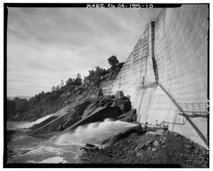
The dam was designed by Raymond A. Hill. It is a special type called a gravity dam with an arched shape. It also has an open spillway, which is like a giant overflow channel.
Construction on the dam started in 1941. This was during World War II. The United States War Department built it. They wanted to supply water to a military base called Camp San Luis Obispo. But the camp ended up having enough water from its own wells. So, the military never used the dam's water.
Today, the city of San Luis Obispo manages the dam. It provides water to the city and nearby farms.
Contents
Building the Salinas Dam
The Salinas Dam is a gravity dam. This means it uses its own weight to hold back the water. It has an arched design. The dam is built at an angle. This allows extra water to flow over it if the lake gets too full.
Dam Size and Features
The dam stands 135 feet tall. It can hold a lot of water. Its maximum capacity is about 26,000 acre-feet of water. An acre-foot is the amount of water needed to cover one acre of land with water one foot deep.
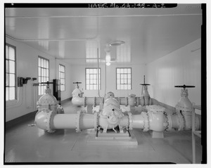
The dam has three ways to take in water. Two are flexible pipes called snorkels. The third is a fixed pipe. Over time, dirt and sand have settled in the lake. This means the dam's actual capacity is now a bit less, around 23,842 acre-feet.
The dam is mostly made of concrete. It was first planned to have a steel gate on its spillway. But this gate was used for another dam instead. So, the spillway remains an open concrete ramp. This ramp is 19 feet deep. It is located at the north end of the dam. If a gate were added, the lake could hold much more water. It could reach up to 46,000 acre-feet. But the dam would need to be strong enough to handle that extra pressure.
Quick Construction
The Army hired engineers to design and build the dam in May 1941. The engineers thought it would take a year to finish. But the Army wanted it done in just six months. So, planning and building happened very quickly. The dam was completed on time in January 1942.
The Salinas Dam project was more than just the dam itself. It also included building a one-mile long tunnel. This tunnel goes through the Santa Lucia Mountain Range. It is called the Cuesta tunnel. It is about six feet wide and eight feet tall. The project also added 9.2 miles of concrete pipe. This system helps water flow by gravity to San Luis Obispo's water treatment plant.
| Dam Feature | Measurement |
|---|---|
| Dam Height | 135 feet |
| Maximum Water Level
(without spillway gate) |
1300.74 feet |
| Maximum Water Capacity
(without spillway gate) |
23,842.90 acre-feet |
How Water Flows from the Dam
The Santa Margarita Reservoir collects water from a large area. This area is 112 square miles. The dam gets water from the Salinas River. It also gets water from three smaller rivers. These are Alamo Creek, Salsipuedes Creek, and Toro Creek.
When the lake's water level is high enough, water can flow by itself. It goes to a booster station near the Santa Lucia mountains. If the water level is too low, pumps are used. They push the water to the booster station.
Once at the mountains, the water needs to be pumped again. It goes for one mile to the Cuesta tunnel entrance. Then it flows through the tunnel. After another mile, gravity takes over again. The water then flows the rest of the way to the water treatment plant.
Who Owns and Manages the Dam
The United States Army first owned the dam. In 1947, it was given to the Army Corps of Engineers. A few months later, the Army Corps of Engineers made an agreement. They let the County of San Luis Obispo Flood Control and Water Conservation District manage the dam.
In 1988, the County Water District made another agreement. They started a program to check the water quality. San Luis Obispo now has the right to use up to 45,000 acre-feet of water from the reservoir. This is almost the dam's full capacity if it had a spillway gate.
Ideas for Expanding the Dam
In 2013, San Luis Obispo studied if the dam could be made bigger. They looked into adding a spillway gate. They also thought about a local group taking over the dam's ownership.
Tests were done to see how the dam would hold up in an earthquake. The study found that if the water level was much higher, the dam might not be strong enough. It also showed that even at its current water level, the dam could have problems during a long earthquake. But these risks were considered acceptable.
In the end, the dam was not expanded. The Army Corps of Engineers still owns it.
