
Templeton, California facts for kids
Quick facts for kids
Templeton
|
|
|---|---|

Templeton Park
|
|

Location in San Luis Obispo County and the state of California
|
|
| Country | |
| State | |
| County | San Luis Obispo |
| Area | |
| • Total | 7.766 sq mi (20.115 km2) |
| • Land | 7.717 sq mi (19.988 km2) |
| • Water | 0.049 sq mi (0.127 km2) 0.63% |
| Elevation | 807 ft (246 m) |
| Population
(2010)
|
|
| • Total | 7,674 |
| • Density | 988.15/sq mi (381.51/km2) |
| Time zone | UTC-8 (Pacific (PST)) |
| • Summer (DST) | UTC-7 (PDT) |
| ZIP code |
93465
|
| Area code(s) | 805 |
| FIPS code | 06-78162 |
| GNIS feature IDs | 1661557, 2410065 |


Templeton is a small community in San Luis Obispo County, California, United States. It is known as a census-designated place (CDP). This means it is a special area identified by the U.S. Census Bureau. In 2010, about 7,674 people lived here. This was a big jump from 4,687 people in 2000.
Contents
About Templeton's Location and Weather
Where is Templeton Located?
Templeton is found at 35.553847 degrees North and 120.709469 degrees West. It is about 5 miles (8 km) south of Paso Robles. It is also 5 miles north of Atascadero. You can find it along U.S. 101. State Route 46 crosses U.S. 101 at the northern edge of town.
The area of Templeton is about 7.8 square miles (20.2 square kilometers). Most of this area is land. However, many nearby areas also use Templeton as their mailing address.
Templeton's Climate and Weather
Templeton has a Mediterranean climate. This means it has mild winters and dry summers. The air usually does not feel very humid. Rain mostly falls between November and March. The rainy season almost stops by the end of April.
Winter temperatures can drop to about 20 to 25 degrees Fahrenheit (-6 to -4 degrees Celsius). Summer highs can reach 100 degrees Fahrenheit (38 degrees Celsius). The hottest temperature ever recorded was 115 degrees Fahrenheit (46 degrees Celsius).
Sometimes, Templeton gets a lot of fog. This happens because of its closeness to the California Coastal Range and the Pacific Ocean. Warm air in the valley rises, and cooler ocean air moves in. This creates fog, especially in summer mornings. In winter, morning fog can also happen due to temperature differences with the Central Valley.
Snow is rare in Templeton. But it did snow on December 15, 1988. About 5 to 8 inches (13 to 20 cm) of snow fell then. It also snowed more recently in the winter of 2023.
Templeton's Economy and Jobs
Templeton has many businesses that support local farming and ranching. The main parts of its economy are medical care, including Twin Cities Hospital, and the Templeton Unified School District. Farming is also very important, especially vineyards and wineries. There are also many different businesses on Main Street. Many people who live in Templeton work in nearby towns.
Templeton is becoming known for its wine. Many wineries that say "Paso Robles" on their labels are actually in the Templeton area. Some of these include Castoro Cellars, Peachy Canyon, York Mountain, and Wild Horse.
Growing olives for food and oil is also increasing. Many small farms produce olives, like Pasolivo.
Templeton's History
Templeton was founded in 1886. It was part of a larger land purchase by the West Coast Land Company. Chauney Hatch Phillips sent R.R. Harris to map out 160 acres for a new town. This town was meant to be south of Paso Robles.
The town was first going to be named "Crocker." This was after Charles F. Crocker, a Vice President of the Southern Pacific Railroad. But Crocker chose to name it "Templeton" instead. He named it after his two-year-old son, Charles Templeton Crocker.
For a short time, Templeton was the end of the railroad line for people traveling south from northern California. Passengers would get off the train in Templeton. Then, they would travel by stagecoach to San Luis Obispo. In 1889, the railroad line was extended. It went 14 miles (23 km) further south to Santa Margarita. Templeton then became a "flag stop," meaning trains would only stop if signaled. Today, the train stops in nearby Paso Robles.
In 1898, a fire destroyed most of the old wooden buildings on Main Street. Because of this, the business area was rebuilt with bricks. It was a bit smaller than before.

Templeton Schools
Templeton has several schools for different age groups:
- Templeton High School - for grades 9 to 12
- Templeton Middle School - for grades 6 to 8
- Vineyard Elementary School - for grades 3 to 5
- Templeton Elementary School - for kindergarten to grade 2
The public schools in Templeton are run by the Templeton Unified School District. Templeton High School is very well-known. It was chosen as a National Blue Ribbon High School in 2006. It was also named a California Distinguished School in 1999 and 2005. Only 64 schools out of 860 in California received this honor.
Famous People from Templeton
Many interesting people have connections to Templeton:

- Brian Barden, a baseball player, was born in Templeton.
- Josh Brolin, a famous actor, grew up in Templeton.
- Kurtis "Miss Fame" Dam-Mikkelsen, a drag queen, makeup artist, model, and recording artist.
- Charles Douglass, who invented the laugh track for TV shows.
- Stewart Finlay-McLennan, an actor.
- Tyler Gray, an NFL linebacker for the Miami Dolphins.
- Spencer Howard, an MLB pitcher.
- Sandy Koufax, a baseball player in the Hall of Fame.
- Steve Webb, a former Mayor of Beverly Hills, California.
Images for kids
-
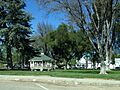
Templeton Park
-
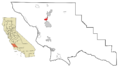
Location in San Luis Obispo County and California
See also
 In Spanish: Templeton (California) para niños
