
Salinas, California facts for kids
Quick facts for kids
Salinas
|
|||
|---|---|---|---|
.jpg)  .jpg) .jpg)  Top: Monterey County Court House; downtown; middle: historic Monterey County Jail building; bottom: Taylor Farms headquarters; downtown.
|
|||
|
|||
| Nickname(s):
"The Salad Bowl of the World"
|
|||
| Motto(s):
"Rich in Land, Rich in Values."
|
|||

Location of Salinas, California
|
|||

Salinas
Location in California

Salinas
Location in the United States
|
|||
| Country | United States | ||
| State | California | ||
| Region | Northern California | ||
| County | Monterey | ||
| Incorporated | March 4, 1874 | ||
| Government | |||
| • Type | Council-Manager | ||
| Area | |||
| • City | 23.45 sq mi (60.74 km2) | ||
| • Land | 23.42 sq mi (60.66 km2) | ||
| • Water | 0.03 sq mi (0.08 km2) 0.16% | ||
| Elevation | 52 ft (16 m) | ||
| Population
(2020)
|
|||
| • City | 163,542 | ||
| • Rank | 1st in Monterey County 35th in California 163rd in the United States |
||
| • Density | 6,974.1/sq mi (2,692.49/km2) | ||
| Time zone | UTC−8 (Pacific) | ||
| • Summer (DST) | UTC−7 (PDT) | ||
| ZIP Codes |
93901–93903, 93905–93908, 93912, and 93915
|
||
| Area code | 831 | ||
| FIPS code | 06-64224 | ||
| GNIS feature IDs | 277589, 2411768 | ||


Salinas (pronounced sah-LEE-nuss) is a city in California, USA. It is the main city of Monterey County. In 2020, about 163,542 people lived there, making it the biggest city in the county.
Salinas is located near the Monterey Bay Area. It's about 10 miles (16 km) southeast of where the Salinas River meets the ocean. The city is at the start of the Salinas Valley. Its weather is greatly affected by the nearby Pacific Ocean.
This city is a major center for business and industry in the region. Its mild ocean climate is perfect for growing flowers, grapes, and vegetables. Salinas is often called "The Salad Bowl of the World." This is because of its huge and active farming industry.
Salinas was the hometown of John Steinbeck, a famous writer who won the Nobel Prize in Literature. Many of his stories are set in the Salinas Valley. The city has a large Hispanic population, making up almost 80% of its residents. It also has a notable Asian-American community, including many people of Filipino heritage.
Contents
- History of Salinas
- Geography and Climate of Salinas
- People and Population of Salinas
- Economy and Jobs in Salinas
- Neighborhoods of Salinas
- Arts and Culture in Salinas
- Education in Salinas
- Media in Salinas
- Transportation in Salinas
- Hospitals in Salinas
- Notable People from Salinas
- Sister Cities of Salinas
- See also
History of Salinas


The area where Salinas is now was first settled by Native Americans. The Esselen people lived here before 200 AD. Later, the Rumsen group of Ohlone people took their place. They lived here for about 1,200 years. Spanish explorers first met the Rumsen-Ohlone people in the 1700s.
When the Spanish arrived, they gave out large pieces of land. Some land went to Catholic Missions. Other land was given to soldiers. After Mexico became independent, smaller land grants were given for ranchos. These ranches were mostly used for raising cattle. This led to a busy trade in cattle hides, shipped from the Port of Monterey.
In the 1850s, two main stagecoach routes met about 18 miles (29 km) east of Monterey. In 1854, American settlers opened a post office at this meeting point. They named their town "Salinas." This name likely came from the original "Rancho Las Salinas" land grant. That name referred to the salt marshes in the area. In 1856, a traveler's inn called the Halfway House opened in Salinas. The streets of Salinas were planned in 1867, and the town officially became a city in 1874.
A big change for Salinas was when grazing land became farmland. The railroad arrived in 1868, making it easier to transport goods and people. In the 1800s, farmers grew wheat, barley, potatoes, and mustard seed. Chinese workers helped drain huge areas of swampland to create more farms. Because many early farm workers were Chinese immigrants, Salinas had the second-largest Chinatown in California. Only San Francisco had a larger one.
Later, Irrigation changed farming in Salinas. Farmers started growing row crops like root vegetables, grapes, and sugar beets. Many big vegetable companies set up their main offices in Salinas. The successful farming industry helped Salinas grow.
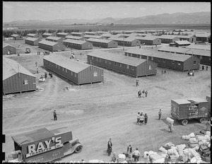
During World War II, the Salinas Rodeo Grounds was used as a temporary camp. It held Japanese-American citizens and residents. This happened after President Roosevelt ordered the removal and confinement of Japanese Americans on the West Coast. The camp opened in April 1942 and held over 3,600 people. It closed two months later in July.

After World War II, much farmland was turned into city areas. Salinas grew quickly in the 1950s and 1960s, and again in the 1990s and early 2000s. The city added nearby communities like Alisal and Santa Rita. New neighborhoods like Harden Ranch, Creekbridge, and Williams Ranch were built.
Salinas is also famous as the birthplace of writer John Steinbeck. The historic downtown, called Oldtown Salinas, has many beautiful Victorian buildings. It is home to the National Steinbeck Center, the Steinbeck House, and the John Steinbeck Library.
Geography and Climate of Salinas

Salinas covers about 23.2 square miles (60.7 square kilometers). Most of this area is land. The city is mostly on flat ground. However, some rolling hills and wooded areas with creeks remain in the northeastern neighborhoods. These natural areas can be seen in Natividad Creek Park.
The city is about 52 feet (18 meters) above sea level. It is roughly eight miles (13 km) from the Pacific Ocean. The Gabilan and Santa Lucia mountain ranges are on the east and west sides of the Salinas Valley.
The Salinas River flows through the Salinas Valley. It empties into the Pacific Ocean at the center of the Monterey Bay. In summer, the river flows partly underground. This underground water source helps irrigate farms in an area that doesn't get much rain.
What is the Climate Like in Salinas?

Salinas has cool and mild temperatures. This is because of a "natural air conditioner" effect. Ocean air and fog from the Monterey Bay keep Salinas cool. Other towns nearby might have hotter summers because mountains block the ocean air.
Salinas has a mild Mediterranean climate. This means it has warm, dry summers and mild, wet winters. Daily high temperatures usually range from about 62°F (17°C) in December to 75°F (24°C) in September. The hottest temperature ever recorded was 107°F (42°C) in September 2017. The coldest was 22°F (-6°C) in January 1963 and 2007.
On average, Salinas has about 6 days a year with temperatures above 90°F (32°C). It also has about 7 days a year where temperatures drop to freezing or below.

During summer, heavy morning fog is common. This is called the marine layer. It is caused by the difference between ocean and air temperatures. This fog helps keep the area cool.
The city gets about 15.38 inches (390.7 mm) of rain each year. The wettest year on record was from July 1997 to June 1998, with 34.63 inches (879.6 mm) of rain. The driest was from July 1971 to June 1972, with only 7.29 inches (185.2 mm).
| Climate data for Salinas, California, 1991–2020 normals, extremes 1958–2018 | |||||||||||||
|---|---|---|---|---|---|---|---|---|---|---|---|---|---|
| Month | Jan | Feb | Mar | Apr | May | Jun | Jul | Aug | Sep | Oct | Nov | Dec | Year |
| Record high °F (°C) | 87 (31) |
90 (32) |
93 (34) |
100 (38) |
100 (38) |
105 (41) |
102 (39) |
102 (39) |
109 (43) |
105 (41) |
96 (36) |
92 (33) |
109 (43) |
| Mean maximum °F (°C) | 76.3 (24.6) |
77.8 (25.4) |
80.9 (27.2) |
84.8 (29.3) |
84.9 (29.4) |
85.0 (29.4) |
82.0 (27.8) |
84.9 (29.4) |
91.9 (33.3) |
92.8 (33.8) |
84.0 (28.9) |
73.6 (23.1) |
96.7 (35.9) |
| Mean daily maximum °F (°C) | 63.4 (17.4) |
64.1 (17.8) |
66.2 (19.0) |
67.3 (19.6) |
68.3 (20.2) |
70.2 (21.2) |
70.9 (21.6) |
72.5 (22.5) |
74.7 (23.7) |
74.2 (23.4) |
68.1 (20.1) |
62.4 (16.9) |
68.5 (20.3) |
| Daily mean °F (°C) | 52.1 (11.2) |
53.2 (11.8) |
54.9 (12.7) |
56.2 (13.4) |
58.4 (14.7) |
60.7 (15.9) |
62.4 (16.9) |
63.4 (17.4) |
63.6 (17.6) |
61.5 (16.4) |
55.8 (13.2) |
51.3 (10.7) |
57.8 (14.3) |
| Mean daily minimum °F (°C) | 40.9 (4.9) |
42.2 (5.7) |
43.7 (6.5) |
45.0 (7.2) |
48.6 (9.2) |
51.2 (10.7) |
53.9 (12.2) |
54.2 (12.3) |
52.5 (11.4) |
48.8 (9.3) |
43.4 (6.3) |
40.2 (4.6) |
47.1 (8.4) |
| Mean minimum °F (°C) | 31.5 (−0.3) |
33.6 (0.9) |
35.3 (1.8) |
37.4 (3.0) |
41.6 (5.3) |
45.1 (7.3) |
48.3 (9.1) |
49.1 (9.5) |
45.9 (7.7) |
40.9 (4.9) |
34.3 (1.3) |
30.4 (−0.9) |
29.2 (−1.6) |
| Record low °F (°C) | 18 (−8) |
22 (−6) |
25 (−4) |
28 (−2) |
29 (−2) |
32 (0) |
35 (2) |
35 (2) |
32 (0) |
26 (−3) |
20 (−7) |
19 (−7) |
18 (−8) |
| Average precipitation inches (mm) | 3.26 (83) |
2.98 (76) |
2.45 (62) |
1.07 (27) |
0.49 (12) |
0.08 (2.0) |
0.01 (0.25) |
0.04 (1.0) |
0.06 (1.5) |
0.61 (15) |
1.58 (40) |
2.75 (70) |
15.38 (389.75) |
| Average precipitation days (≥ 0.01 in.) | 9.4 | 9.8 | 8.2 | 5.7 | 3.0 | 1.0 | 0.5 | 1.0 | 0.9 | 2.9 | 6.1 | 9.5 | 58.0 |
| Source 1: NOAA | |||||||||||||
| Source 2: National Weather Service | |||||||||||||
People and Population of Salinas
| Historical population | |||
|---|---|---|---|
| Census | Pop. | %± | |
| 1870 | 599 | — | |
| 1880 | 1,854 | 209.5% | |
| 1890 | 2,339 | 26.2% | |
| 1900 | 3,304 | 41.3% | |
| 1910 | 3,736 | 13.1% | |
| 1920 | 4,308 | 15.3% | |
| 1930 | 10,263 | 138.2% | |
| 1940 | 11,586 | 12.9% | |
| 1950 | 13,917 | 20.1% | |
| 1960 | 28,957 | 108.1% | |
| 1970 | 58,896 | 103.4% | |
| 1980 | 80,479 | 36.6% | |
| 1990 | 108,777 | 35.2% | |
| 2000 | 151,060 | 38.9% | |
| 2010 | 150,441 | −0.4% | |
| 2020 | 163,542 | 8.7% | |
| 2023 (est.) | 167,472 | 11.3% | |
| U.S. Decennial Census | |||
In 2020, Salinas had a population of 163,542 people. About 79% of the people in Salinas are of Hispanic or Latino background. This is a very high percentage for a city in California. The city also has a notable Asian-American population.
The average household income in Salinas was about $67,914. The average income per person was about $23,707. About 14% of the population lived below the poverty line.
| Race / Ethnicity (NH = Non-Hispanic) | Pop 2000 | Pop 2010 | Pop 2020 | % 2000 | % 2010 | % 2020 |
|---|---|---|---|---|---|---|
| White alone (NH) | 36,535 | 23,333 | 18,351 | 24.19% | 15.51% | 11.22% |
| Black or African American alone (NH) | 4,569 | 2,343 | 1,927 | 3.02% | 1.56% | 1.18% |
| Native American or Alaska Native alone (NH) | 636 | 418 | 428 | 0.42% | 0.28% | 0.26% |
| Asian alone (NH) | 8,840 | 8,677 | 8,870 | 5.85% | 5.77% | 5.42% |
| Pacific Islander alone (NH) | 275 | 383 | 342 | 0.18% | 0.25% | 0.21% |
| Some Other Race alone (NH) | 508 | 218 | 651 | 0.34% | 0.14% | 0.40% |
| Mixed Race or Multi-Racial (NH) | 2,817 | 2,270 | 2,795 | 1.86% | 1.51% | 1.71% |
| Hispanic or Latino (any race) | 96,880 | 112,799 | 130,178 | 64.13% | 74.98% | 79.60% |
| Total | 151,060 | 150,441 | 163,542 | 100.00% | 100.00% | 100.00% |
Economy and Jobs in Salinas
Salinas is known for its strong agricultural industry. Many major employers in the city are related to farming. These include companies like Taylor Farms, Tanimura & Antle, and Mann Packing. The city also has important hospitals like Salinas Valley Memorial Hospital and Natividad Medical Center.
Salinas is becoming a leader in "AgTech." This means using technology in farming. It's called the "AgTech Capital" because it's close to Silicon Valley. This makes it a great place to develop new farming technologies.
What is the Forbes AgTech Summit?
Since 2015, the magazine Forbes has held a yearly event in Salinas called the Forbes AgTech Summit. This event brings together people who create new farming technologies from all over the world. It includes talks, discussions, and demonstrations of new ideas.
Neighborhoods of Salinas
Salinas is divided into several main areas, each with its own neighborhoods:
North Salinas
- Harden Ranch
- Santa Rita
- Northridge
- Santa Lucia Village
- Sherwood Gardens
- Creekbridge
East Salinas
- Sunset
- Alisal
- Monte Bella
- Williams Ranch
South Salinas
- Maple Park
West Salinas
- Laurelwood
- Boronda (a nearby community)
- Westridge
Downtown Salinas
- Old Town
Arts and Culture in Salinas
_Theater,_Salinas,_CA.jpg)
Salinas has a growing arts scene. There's an event called First Fridays Art Walk. During this event, local art is shown in many different places, including businesses. The Valley Art Gallery is the oldest gallery in Salinas, open for over 30 years.
Hartnell College Gallery shows art from around the world. The National Steinbeck Center also has galleries with changing exhibits.
Live Performances and Art
Live theater groups in Salinas include ARIEL Theatrical and The Western Stage. You can find live music at many restaurants downtown. Concerts are held at the historic Fox California Theater and the Salinas Sports Complex.
Salinas has many public murals. Some are by artist John Cerney and can be seen in the fields around the city. Claes Oldenburg created a sculpture called Hat in Three Stages of Landing. It is located in Sherwood Park.
Many buildings in the city have an Art Deco style. Examples include the Monterey County Courthouse.
Cultural Events and Festivals

What is El Grito?
El Grito is a free yearly event in the Alisal Neighborhood. It happens every September and celebrates the start of the Mexican War of Independence. Up to 65,000 people attend. The event includes a parade, performances, food, and cultural displays.
What is Founders Day?
Salinas Founders Day is a yearly event that started in 1869. It celebrates the history of Salinas. The event includes tours of historic buildings, music, and talks about the city's past.
What is Ciclovía Salinas?
.jpg)
Ciclovía Salinas is a yearly event that began in 2013. A 1.5-mile (2.4 km) section of Alisal Street is closed to cars. It's only for people walking, biking, and using other non-motorized ways to get around. The goal is to encourage healthy activities. This event is run by youth volunteers from Salinas.
What is the California Rodeo Salinas?
Salinas hosts a major professional rodeo event called the California Rodeo Salinas. It started in 1911. Every third week of July is "Big Week." Cowboys and fans come for rodeo competitions, including bull riding. There are also other events like cowboy poetry, wine tasting, and a carnival.
What is the Kiddie Kapers Parade?
The Kiddie Kapers Parade started in 1930. It's a yearly parade where only children in costumes participate. It happens during "Big Week" with the Rodeo.
What is the Salinas Asian Festival?

The Salinas Asian Festival is a free yearly event. It celebrates the culture and history of Chinese, Filipino, and Japanese immigrants in Salinas. The festival includes food, demonstrations of tai chi, folk dancing, and a bonsai display.
Places to Visit in Salinas
John Steinbeck House
The John Steinbeck House was the birthplace and childhood home of author John Steinbeck. It is now a restaurant. The house was built in 1897 and is a beautiful Victorian-style building.
Boronda Adobe History Center
Just outside the city, you can find the Boronda Adobe History Center. It has a restored adobe house built in 1844. This house is a California Historical Landmark. It also has a museum about early Salinas and California history. Other historic buildings are there, including the Lagunita School house.
Santa Lucia Highlands American Viticultural Area
The Santa Lucia Highlands AVA is a nearby area known for growing grapes. It's becoming a popular place for wine tasting.
Education in Salinas
School Districts
Salinas has seven public school districts. The largest is the Salinas Union High School District (grades 7–12). It has 10 schools and over 13,500 students. The Salinas City Elementary School District is the largest for younger students.
Private Catholic schools in Salinas include Palma School and Notre Dame High School (for girls).
Colleges and Universities
Hartnell College is located in Salinas. There is also a branch campus of California State University, Monterey Bay in the city.
Media in Salinas
Local newspapers include The Salinas Californian.
Salinas has many local radio stations. Television service comes from the Monterey-Salinas-Santa Cruz area. Local channels like KION-TV and KSBW provide news for the area.
Transportation in Salinas
Highways and Roads
U.S. Route 101 is the main highway in Salinas. It connects the city to other parts of the Central Coast. It also links to San Francisco in the north and Los Angeles in the south. California State Route 68 goes west to Monterey.
Train Service

Amtrak, the national passenger train system, serves Salinas. Its Coast Starlight train stops in Salinas daily. It travels between Seattle, Washington, and Los Angeles. There are plans to extend train service to Gilroy and San Jose by 2024.
Bus Service
Monterey–Salinas Transit (MST) provides public bus transportation. Buses take passengers throughout the county. They also go to San Jose and Gilroy. In those cities, you can connect to other train services. Greyhound also operates from the Salinas Amtrak station.
Airport
Salinas Municipal Airport is located on the southeastern side of the city. It is a general aviation airport. This means it's mostly for smaller planes and helicopters. The airport has an air traffic control tower.
The airport hosts the California International Airshow every year. This event brings thousands of visitors to Salinas.
Hospitals in Salinas
Salinas has two main hospitals: Salinas Valley Memorial Hospital and Natividad Medical Center. Natividad Medical Center is a teaching hospital. It offers medical interpreters for several languages, including Spanish and some Oaxacan languages.
Notable People from Salinas


Many interesting people have come from Salinas, including:
- Monica Abbott, Olympic softball pitcher
- Dustin Lance Black, Academy Award-winning screenwriter
- John Steinbeck, famous author and Nobel Prize winner
- Vanessa Hudgens, singer and actress
- Sammy Hagar, singer, known from the band Van Halen
- Cain Velasquez, UFC heavyweight champion (mixed martial arts fighter)
Sister Cities of Salinas
Salinas has several sister cities around the world:
- Cebu City, Philippines (since 1964)
- Ichikikushikino, Japan (since 1979)
- Jerécuaro, Mexico (since 1996)
- Guanajuato, Mexico (since 2007)
- Drogheda, Ireland (since 2012)
- Söke, Turkey (since 2015)
- Seogwipo, South Korea (since 2018)
|
See also
 In Spanish: Salinas (California) para niños
