
Moss Landing, California facts for kids
Quick facts for kids
Moss Landing, California
|
|
|---|---|

Aerial view
|
|

Location in Monterey County and the state of California
|
|

Moss Landing, California
Location in the United States
|
|
| Country | |
| State | |
| County | Monterey |
| Area | |
| • Total | 0.602 sq mi (1.56 km2) |
| • Land | 0.392 sq mi (1.02 km2) |
| • Water | 0.210 sq mi (0.54 km2) 34.88% |
| Elevation | 10 ft (3 m) |
| Population
(2020)
|
|
| • Total | 237 |
| • Density | 604.6/sq mi (233.4/km2) |
| Time zone | UTC-8 (Pacific) |
| • Summer (DST) | UTC-7 (PDT) |
| ZIP code |
95039
|
| Area code | 831 |
| FIPS code | 06-49488 |
| GNIS feature IDs | 1659184, 2408874 |
Moss Landing, once called Moss, is a small community in Monterey County, California, United States. It's located about 18 miles (29 km) north of Monterey. The town sits right on the shore of Monterey Bay. It is also at the start of Elkhorn Slough, which is a unique water area. The deep Monterey Canyon is also found nearby, under the ocean.
Contents
History of Moss Landing
The first people to live in the Moss Landing area were the Ohlone people. They might have lived here as long as 4,000 years ago. In the 1700s, the Spanish arrived and forced the Ohlone into their mission system. Many Ohlone people did not survive this change.
After the Spanish missions were closed down, the Spanish government gave large pieces of land, called ranchos, to soldiers. One of these was the 30,901-acre (125 km²) Rancho Bolsa Nueva y Moro Cojo. This land stretched from Moss Landing to Prunedale and south to Castroville.
People farmed the land and raised cattle. In the mid-1800s, Americans arrived and turned the area into farmland.
How Moss Landing Got Its Name
In the early 1860s, a ship captain named Charles Moss started a landing and wharf here. This was to help with the growing grain trade from the Salinas Valley.
William B. Post was a skilled hunter who traded animal hides. This work brought him to Moss Landing. He opened one of the first grain warehouses along the coast. Flat-bottom boats brought grain from the Salinas Valley to Elkhorn Slough, unloading it at Post's warehouse. The success of this shipping point helped the nearby town of Castroville grow.
The place was first named "Moss" after Charles Moss. The post office opened in 1895. In 1917, its name changed to "Moss Landing."
Growth and Development
Moss Landing became a busy port for whaling and fishing. Fish processing plants and canneries also opened here. The Moss Landing Harbor District was created in the 1940s. They dug channels and built piers to improve the harbor.
The Moss Landing Power Plant opened in 1950. Later, in 1966, the California State University system started the Moss Landing Marine Laboratories. This lab was rebuilt after the Loma Prieta Earthquake in 1989. In the mid-1990s, the Monterey Bay Aquarium Research Institute (MBARI) moved to Moss Landing. In the 1980s, new sewer systems were installed to help with water pollution.
Geography and Climate
Moss Landing is in northern Monterey County. It's where Elkhorn Slough meets Monterey Bay. California State Route 1 runs along the east side of the community. This road goes north to Watsonville and southwest to Monterey.
The community covers about 0.6 square miles (1.6 km²). About 0.4 square miles (1.0 km²) is land, and 0.2 square miles (0.5 km²) is water.
Moss Landing's Weather
Moss Landing has a warm-summer Mediterranean climate. This means it has warm, dry summers. The average monthly temperatures do not go above 71.6 °F (22 °C).
People in Moss Landing
Moss Landing is a small community. According to the 2020 census, 237 people live here.
Population in 2010
The 2010 United States Census counted 204 people in Moss Landing. Most residents were White (73.0%). About 14.7% were from other races, and 6.9% were from two or more races. About 22.5% of the population was Hispanic or Latino.
The average age of people in Moss Landing was 46.5 years. About 15.7% of the population was under 18 years old.
Population in 2000
In the census of 2000, there were 300 people living in Moss Landing. The racial makeup was 59.33% White. About 21.67% were from other races, and 13.33% were from two or more races. About 28.3% of the population was Hispanic or Latino.
The median age was 36 years. About 21.3% of the population was under 18 years old.
Economy and Jobs
Moss Landing is home to important research facilities and a large power plant. Tourism is also a big part of its economy.
Research and Science
The Moss Landing Marine Laboratories is a research center for the California State University system. Scientists here study the ocean. The Monterey Bay Aquarium Research Institute (MBARI) is also in Moss Landing. It's a sister organization to the Monterey Bay Aquarium and focuses on ocean research and technology.
Moss Landing Power Plant
The Moss Landing Power Plant uses natural gas to create electricity. It also has the world's largest battery storage facility. This plant can be seen from Santa Cruz, California to the north and Monterey to the south. It produces a lot of power, but it's mainly used as a backup for California's electricity grid.
There have been a few fires at the battery storage facility in recent years. These fires caused the plant to shut down and released some air pollutants.
Tourism in Moss Landing
Tourism is very important to Moss Landing. Many people visit to enjoy the natural beauty and activities.
Fun Things to Do
Moss Landing has several events and attractions that make it a great place to visit.
Annual Events
The Moss Landing Antique Street Fair happens every year on the last Sunday in July. Hundreds of antique sellers come, and many visitors enjoy finding treasures.
Other events include the start of rock cod fishing season in May, an open house at Moss Landing Marine Labs in April or May, and a Nautical Flea Market in May.
Exploring Moss Landing
Moss Landing is known as the main entry point to Elkhorn Slough. This is one of the largest wetlands in California. Elkhorn Slough is famous for birdwatching, with over 350 species of birds migrating through each year. It's also one of the best places in the world to see sea otters.
Moss Landing has many restaurants, art galleries, and a bed and breakfast. Its harbor is home to over 600 boats, including fishing boats, pleasure boats, and research vessels. Commercial boats here catch various types of fish and seafood. The harbor also has public boat launches and a community park.
Moss Landing is also home to the Shakespeare Society of America.
Parks and Nature Areas
Moss Landing offers access to several protected natural areas. These include:
- Moss Landing State Beach (a popular spot for surfing)
- Salinas River State Beach
- Zmudowski State Beach
- Moss Landing Wildlife Area
- Elkhorn Slough National Estuarine Research Reserve
Images for kids
-
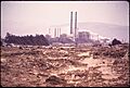
Moss Landing in 1972
-
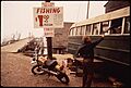
Another view of Moss Landing in 1972
-
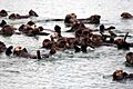
Sea otters playing at Moss Landing harbor


See also
 In Spanish: Moss Landing para niños
