
Castroville, California facts for kids
Quick facts for kids
Castroville, California
|
|
|---|---|

Castroville sign and La Scuola on Merritt Street
|
|
| Nickname(s):
"The Artichoke Center of the World"
|
|

Location in Monterey County and the state of California
|
|

Castroville, California
Location in the United States
|
|
| Country | |
| State | |
| County | Monterey |
| Founded | 1863 |
| Government | |
| • Type | N/A |
| Area | |
| • Total | 1.02 sq mi (2.6 km2) |
| • Land | 1.02 sq mi (2.6 km2) |
| • Water | 0.00 sq mi (0 km2) 0% |
| Elevation | 23 ft (7 m) |
| Population
(2020)
|
|
| • Total | 7,515 |
| • Density | 7,353.23/sq mi (2,839.10/km2) |
| Time zone | UTC-8 (PST) |
| • Summer (DST) | UTC-7 (PDT) |
| ZIP code |
95012
|
| Area code(s) | 831 |
| FIPS code | 06-11978 |
| GNIS feature ID | 277486 |
Castroville is a small town in Monterey County, California, United States. It's known as a "census-designated place" (CDP), which means it's a community that the government counts for population, but it's not officially a city. In 2020, about 7,515 people lived there.
Castroville is famous for growing artichokes. It even has an annual Castroville Artichoke Festival! This is why it's called the "Artichoke Center of the World." The town began in 1863, founded by Juan Bautista Castro. It was built on land that used to be a large Mexican ranch.
Contents
History of Castroville
.jpg)
The land where Castroville now stands was once part of a big Mexican ranch called Rancho Bolsa Nueva y Moro Cojo. This ranch was given to Juan Bautista Castro's mother in 1844. After California became part of the United States, Juan Bautista Castro started the town of Castroville in 1863.
Early Days of Castroville
The town was carefully planned with blocks of land for homes. To encourage people to move there, 100 lots were given away. Anyone who would clear the land and build a house could get a free lot! In 1870, a local newspaper even offered free lots to people who would build good homes.
Juan Bautista Castro was an important leader. He ran for county supervisor and won, helping to build low-income housing in the town. By 1875, Castroville had about 900 residents. It had many businesses, including hotels, stores, a newspaper, churches, and a school.
The Southern Pacific Railroad was building its lines south. Castroville hoped to be a major train stop. However, the nearby city of Salinas offered land for free, so the main train station went there instead. Still, Castroville was an important stop, connecting towns like Monterey and Soledad to San Francisco.
The Castroville Argus Newspaper
The Castroville Argus was the town's newspaper, started on July 17, 1869. Juan Bautista Castro was one of its publishers. It was a weekly paper, meaning a new edition came out every Saturday.
Manuel R. Merritt, one of the editors, was a very active person. He was also a county supervisor, Postmaster, and Justice of the Peace. He worked in real estate and insurance too.
Chinatown in Castroville
In the 1860s, Chinese workers came to Castroville. They helped clear the wet, swampy lands, making it ready for farming. In 1878, Chinese businesses moved to a new area. A fire destroyed this Chinatown in 1883, but it was quickly rebuilt.
Many Chinese companies farmed sugar beets in the Castroville area. This led to a "Sugar Beet Rush" as more farms and people came. In 1891, some Chinese individuals and companies even bought land in Castroville. This was a big deal because it was the first time Chinese people owned property in the Monterey Bay Area.
Later, laws like the California Alien Land Law of 1913 made it hard for Chinese, Japanese, and other Asian immigrants to own farmland. This law was meant to stop immigration. However, many farmers in Castroville stood up for the Chinese workers. They knew that without them, the farming industry would struggle. Even with these challenges, Chinese workers made huge contributions to farming, railroads, and fishing in the area.
The First Artichokes

Spanish settlers first brought artichokes to California. In the early 1920s, the first artichoke fields in California grew near Half Moon Bay. In 1922, Andrew Molera planted the first artichoke plants in Castroville. Soon after, other growers leased land and started growing artichokes too.
By 1923, there were nine artichoke growers. Just four years later, over 50 growers were farming 12,000 acres of artichokes in the area! In 1924, some of these growers formed a company that later became "Ocean Mist Farms." You can even see the Giant Artichoke statue in Castroville, which was built in 1963. It's the biggest artichoke statue in the world!
Artichoke Queens
Castroville has a tradition of crowning an Artichoke Queen. The first queen was Sally DeSante Hebert, crowned in 1961. She was involved in many community groups.
In 1948, the famous actress Marilyn Monroe visited the Monterey Bay area. She was promoting her career and signing autographs. During her visit, she was given a sash and named "California Artichoke Queen" by a local club. Pictures of Marilyn holding artichokes were used in advertisements, helping to promote the artichoke industry.
Geography and Climate
Castroville is in northern Monterey County. It's about 8 miles (13 km) northwest of Salinas, which is the county seat. It's also about 16 miles (26 km) northeast of Monterey and 28 miles (45 km) southeast of Santa Cruz.
The town is near important natural areas. The Elkhorn Slough National Estuarine Research Reserve is about 5 miles (8 km) north. This is a special place where the ocean meets a river, creating a unique habitat for wildlife. The Salinas River National Wildlife Refuge is also nearby, where the Salinas River flows into Monterey Bay.
Castroville has a cool-summer Mediterranean climate. This means it has mild winters and cool summers. The warmest month is September, and the coolest is January. There isn't a clear wet or dry season because much of the rain comes from different types of fog throughout the year.
Population Information
| Historical population | |||
|---|---|---|---|
| Census | Pop. | %± | |
| 2000 | 6,724 | — | |
| 2010 | 6,481 | −3.6% | |
| 2020 | 7,515 | 16.0% | |
| U.S. Decennial Census | |||
In 2020, Castroville had a population of 7,515 people. This was an increase from 6,481 people in 2010.
Who Lives in Castroville?
According to the 2010 census, most people in Castroville are of Hispanic or Latino background (about 90%). The population is quite young, with about 33.5% of people under the age of 18. The average age in Castroville was about 26.7 years old.
Many households in Castroville have children. The average household had about 4.40 people living in it. About 40.5% of people lived in homes they owned, while 59.3% lived in rented homes.
Getting Around Castroville

Several main roads meet in Castroville, including California Highways 1, 156, and 183. Highway 156 connects to Highway 101, a major route. Highway 1 leads to Monterey and Santa Cruz, and Highway 183 connects to Salinas.
Merritt Street is the main street in Castroville. Many businesses are located in the industrial park on Blackie Road. Over the years, the Castroville Redevelopment Agency has helped fund many public roads and housing projects in the town.
Future Train Plans
There are plans to build a train station in Castroville in the future. This would be part of a project to extend Caltrain service from Gilroy to Salinas. In the long term, Amtrak trains might also be extended to Salinas, which would be great for people traveling to and from Castroville.
Notable People
- Jamie Iredell, a writer.
Images for kids
-
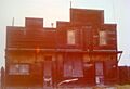
The Saloon, the last standing building in Chinatown
-
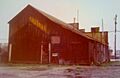
The Saloon, Rear View
-
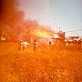
Saloon on Fire


See also
 In Spanish: Castroville (California) para niños
