Stanford, California facts for kids
Quick facts for kids
Stanford
|
|
|---|---|

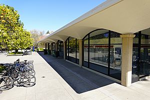
Stanford post office
|
|

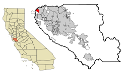
Location in Santa Clara County and the state of California
|
|
| Country | United States |
| State | California |
| County | Santa Clara |
| Area | |
| • Total | 2.776 sq mi (7.190 km2) |
| • Land | 2.731 sq mi (7.072 km2) |
| • Water | 0.045 sq mi (0.118 km2) 1.64% |
| Elevation | 95 ft (29 m) |
| Population
(2020)
|
|
| • Total | 21,150 |
| • Density | 7,619/sq mi (2,941.6/km2) |
| Time zone | UTC−8 (Pacific) |
| • Summer (DST) | UTC−7 (PDT) |
| ZIP Codes |
94305, 94309
|
| Area code | 650 |
| FIPS code | 06-73906 |
| GNIS feature IDs | 1867061, 2409994 |
Stanford is a special area in Santa Clara County, California, United States. It is called a census-designated place (CDP). This means it's a community that the government counts for population, but it's not officially a city.
Stanford is famous for being the home of Stanford University. The area is named after the university itself. In 2020, about 21,150 people lived here.
Most of the Stanford University campus is located within this area. However, some parts, like the Stanford University Medical Center and the Stanford Shopping Center, are actually part of the nearby city of Palo Alto.
Contents
Exploring Stanford's Location and Size
Stanford is located in the northwest part of Santa Clara County. Its exact coordinates are 37.422590 degrees North and -122.165413 degrees West.
The total area of Stanford is about 2.8 square miles (7.2 square kilometers). Most of this area is land, around 2.7 square miles (7.0 square kilometers). A small part, about 0.045 square miles (0.118 square kilometers), is water.
Understanding Stanford's Climate
Stanford has a climate known as a warm-summer Mediterranean climate. This means it has warm, dry summers and cool, wet winters.
During the summer, the average monthly temperatures do not go above 77.6°F (25.3°C). In winter, the average monthly temperatures do not drop below 37.7°F (3.2°C). This type of climate is often found in areas like the Mediterranean Sea region.
| Climate data for Stanford, California | |||||||||||||
|---|---|---|---|---|---|---|---|---|---|---|---|---|---|
| Month | Jan | Feb | Mar | Apr | May | Jun | Jul | Aug | Sep | Oct | Nov | Dec | Year |
| Record high °F (°C) | 71 (22) |
79 (26) |
84 (29) |
91 (33) |
97 (36) |
102 (39) |
105 (41) |
100 (38) |
103 (39) |
95 (35) |
84 (29) |
75 (24) |
105 (41) |
| Mean daily maximum °F (°C) | 55.5 (13.1) |
59.8 (15.4) |
63.7 (17.6) |
67.2 (19.6) |
72 (22) |
76.1 (24.5) |
77.6 (25.3) |
76.6 (24.8) |
76.7 (24.8) |
71.9 (22.2) |
64.6 (18.1) |
56.8 (13.8) |
68.2 (20.1) |
| Daily mean °F (°C) | 46.6 (8.1) |
50.2 (10.1) |
53.2 (11.8) |
56.2 (13.4) |
60.1 (15.6) |
63.7 (17.6) |
65.6 (18.7) |
65 (18) |
64.1 (17.8) |
59.9 (15.5) |
53.3 (11.8) |
48 (9) |
57.2 (14.0) |
| Mean daily minimum °F (°C) | 37.7 (3.2) |
40.6 (4.8) |
42.7 (5.9) |
45.1 (7.3) |
48.2 (9.0) |
51.3 (10.7) |
53.5 (11.9) |
53.5 (11.9) |
51.5 (10.8) |
47.9 (8.8) |
42 (6) |
39.2 (4.0) |
46.1 (7.9) |
| Record low °F (°C) | 20 (−7) |
25 (−4) |
25 (−4) |
31 (−1) |
36 (2) |
40 (4) |
40 (4) |
44 (7) |
39 (4) |
32 (0) |
26 (−3) |
22 (−6) |
20 (−7) |
| Average rainfall inches (mm) | 2.7 (69) |
2.7 (69) |
2.1 (53) |
1.1 (28) |
0.5 (13) |
0.1 (2.5) |
0 (0) |
0 (0) |
0.1 (2.5) |
0.7 (18) |
1.6 (41) |
3.2 (81) |
14.8 (377) |
| Average rainy days (≥ 0.01 in) | 10 | 10 | 8 | 5 | 3 | 1 | 0 | 0 | 1 | 3 | 6 | 10 | 57 |
| Source: Climate Summary for Stanford, California | |||||||||||||
Who Lives in Stanford? A Look at the Population
| Historical population | |||
|---|---|---|---|
| Census | Pop. | %± | |
| 2000 | 13,314 | — | |
| 2010 | 13,809 | 3.7% | |
| 2020 | 21,150 | 53.2% | |
| U.S. Decennial Census | |||
The population of Stanford has grown over the years. In 2000, there were 13,314 people. By 2010, it increased to 13,809, and in 2020, the population reached 21,150.
Many people living in Stanford are students or faculty members of Stanford University. This includes students living in dorms and professors who own homes on university-leased land.
Population Details from 2010
In 2010, Stanford had a population of 13,809 people. The population density was about 4,974.5 people per square mile.
- Most residents (57.4%) were White.
- About 27.4% were Asian.
- African Americans made up 4.7% of the population.
- People of Hispanic or Latino origin made up 10.4% of the population.
The average age of people in Stanford in 2010 was 22.6 years. This is quite young, mainly because of the large number of university students.
Learning in Stanford: Schools and Education
The Stanford CDP is part of the Palo Alto Unified School District. This district provides education for students from kindergarten all the way through high school.
Two elementary schools from this district are located within Stanford:
- Escondido Elementary School
- Lucille M. Nixon Elementary School
For younger children, there are also preschools in Stanford:
- The Bing Nursery School, run by Stanford University.
- The Children's Center of the Stanford Community, which is a cooperative run by parents and teachers.
Famous People Connected to Stanford
Here are some notable people who have lived in Stanford, California:
- John Gall (born 1978): A former professional baseball player. He played as an outfielder and first baseman for teams like the St. Louis Cardinals and the Florida Marlins.
- Marco Zappacosta (born 1985): He is known as the co-founder and CEO of Thumbtack, an online service that helps people find local professionals.
See also
 In Spanish: Stanford (California) para niños
 | Leon Lynch |
 | Milton P. Webster |
 | Ferdinand Smith |


