
San Mateo Creek (San Francisco Bay Area) facts for kids
Quick facts for kids San Mateo Creek |
|
|---|---|
.jpg)
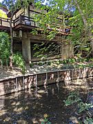
San Mateo Creek just downstream of Gateway Park, where the creek passes under the intersection of Third and Humboldt (Aug 2018)
|
|

Location of the mouth of San Mateo Creek in California
|
|
| Other name(s) | Arroyo De San Mateo, Arroyo De San Matheo |
| Country | United States |
| State | California |
| Region | San Francisco Peninsula |
| County | San Mateo County |
| Cities | Hillsborough, San Mateo |
| Physical characteristics | |
| Main source | 1,000 ft (300 m) 37°35′35″N 122°26′59″W / 37.59306°N 122.44972°W |
| River mouth | 7 ft (2.1 m) 37°34′30″N 122°18′17″W / 37.57500°N 122.30472°W |
| Length | 12 mi (19 km) |
| Basin features | |
| Tributaries |
|
San Mateo Creek is a stream in San Mateo County, California. Its name means "St. Matthew Creek" in Spanish. This creek is the only natural way for water to flow out of the Crystal Springs Reservoir. It eventually empties into the San Francisco Bay.
Contents
History of San Mateo Creek

The area around San Mateo Creek has a long history. Explorers from Spain were some of the first Europeans to visit.
Early Explorers and Campsites
In 1769, the Portolá expedition discovered San Francisco Bay. They traveled down a valley that Portolá called Cañada de San Francisco. This was likely San Andreas Creek or San Mateo Creek.
The group camped near a large lake called "Laguna Grande." Today, this area is covered by the Upper Crystal Springs Reservoir. A special marker, California Historical Marker No. 94, shows where they camped. They even camped there a second time on their way back.
Renaming the Creek and Fault
In 1774, another explorer, Padre Palóu, renamed the valley. He called it Cañada de San Andrés on November 30, which was St. Andrew's feast day. Later, this name was used for the famous San Andreas Fault. This fault is a big crack in the Earth's crust.
De Anza's Journey and Camp
In 1776, Captain Juan Bautista de Anza led another expedition. Instead of staying by the coast, they went inland. They followed the Santa Clara Valley to San Francisco Bay. Then they traveled up the peninsula.
.jpg)
De Anza's group chose the spots for Mission San Francisco de Asís and the Presidio of San Francisco. On their way back, they camped by San Mateo Creek on March 29, 1776. De Anza wrote in his diary that the local people were very friendly and helpful.
A few months later, more people from de Anza's group also camped here. They were families, soldiers, and priests going to help build the mission and presidio. A plaque at Arroyo Court in San Mateo marks this important historical spot. It is called "California State Historical Landmark No. 47 Anza Expedition Camp."
San Mateo Creek Watershed
A watershed is an area of land where all the water drains into one main river or stream. San Mateo Creek's watershed includes the large Crystal Springs Reservoir.
Creek's Journey from Source to Bay
San Mateo Creek starts high up on Sweeney Ridge, almost 1,000 feet above sea level. It flows for about 7 miles (11.2 km) before reaching the Lower Crystal Springs Reservoir.
One of its important branches is San Andreas Creek. This creek flows into the reservoir from the northeast. Another branch, Laguna Creek, flows north from Woodside.
Crystal Springs Reservoir and Dams
The Crystal Springs Reservoir is made up of two lakes. The Upper Crystal Springs Reservoir was formed in 1877 by an earthen dam. This dam covered the old "Laguna Grande" lake.
Later, in 1888, a concrete dam called the Crystal Springs Dam was built. This dam blocked San Mateo Creek and created the Lower Crystal Springs Reservoir. Today, Highway 92 crosses the old earthen dam, which is now a causeway.
Besides the creeks, the reservoir also gets water from the Santa Cruz Mountains. It also receives water from the Hetch Hetchy Aqueduct, which brings water all the way from the Sierra Nevada mountains.
From the Crystal Springs Dam, San Mateo Creek flows about 5 miles (8 km) through the city of San Mateo. It then reaches San Francisco Bay. The creek is entirely within San Mateo County.
Ecology and Wildlife

San Mateo Creek is home to different plants and animals. In the past, it was an important place for fish.
Fish in the Creek
Long ago, coho salmon and steelhead trout lived in San Mateo Creek. Scientists collected samples of these fish in the 1850s and 1860s. Chinook salmon were also found in San Mateo Creek and other nearby creeks.
Unique Plants and Fog Drip
The upper parts of the watershed get a special kind of moisture called "fog drip." This happens when fog collects on trees and then drips to the ground. This extra water helps unique plants grow.
For example, on Cahill Ridge, scientists found that tanoak and Douglas fir trees collected a lot of fog drip. Some trees produced 59 inches of water from fog in just five weeks! This was more than the total yearly rainfall in nearby grassy areas.
This moist environment supports rare orchids like giant helleborine and phantom orchid. These plants are found only in these damp, foggy ridge tops.
Different Parts of the Creek
The creek flows through different types of areas:
- Upper Reach: Below the Crystal Springs Dam, the creek flows through open spaces and quiet neighborhoods in Hillsborough and San Mateo, California. This area has California oak woodlands and special serpentine grasslands. Many rare plants grow here because of the unique soil and weather.
- Middle Reach: The creek then enters more populated areas with homes, schools, parks, and shops. In downtown San Mateo, parts of the creek flow underground in a culvert (a covered channel).
- Lowest Reach: Near the bay, San Mateo Creek becomes tidal. This means its water level changes with the ocean tides. It flows into San Francisco Bay between Ryder Park and Seal Point Park.
Wetlands and Endangered Species
The area where the creek meets the bay has wetlands and mudflats. These are important habitats for animals. The California clapper rail, an endangered bird, lives in these areas.
In 2002, San Mateo Creek was noted for having a substance called diazinon in its water. However, diazinon is now banned for use on golf courses by the U.S. Government. There is one golf course in San Mateo that drains into the creek, and another drains into the Crystal Springs Reservoir.
Watercourse gallery
-
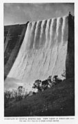
Crystal Springs Dam, 1911
-
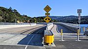
Roadways added on top of dam
-
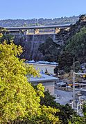
Dam view from under Interstate 280
-
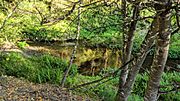
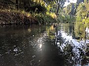
Below the dam
-
Near California Historical Landmark no. 47
-
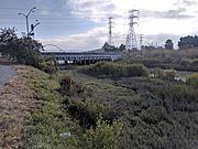
At Gateway Park
-
Above J. Hart Clinton Drive bridge
-
Pedestrian bridge at Ryder Park
-
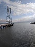
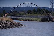
Mouth at Ryder Park


.jpg)
.jpg)
.jpg)
.jpg)
.jpg)
