Lagunitas Creek facts for kids
Quick facts for kids Lagunitas Creek |
|
|---|---|

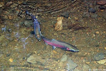
Pair of endangered coho salmon in Lagunitas Creek.
|
|
| Native name | Tokelalume |
| Other name(s) | Arroyo de San Geronimo, Paper Mill Creek |
| Country | United States |
| State | California |
| Region | Marin County |
| Physical characteristics | |
| Main source | Mount Tamalpais 37°56′51″N 122°35′50″W / 37.94750°N 122.59722°W |
| River mouth | Tomales Bay 0 ft (0 m) 38°4′48″N 122°49′37″W / 38.08000°N 122.82694°W |
| Length | 20 mi (32 km) |
| Basin features | |
| Basin size | 103 sq mi (270 km2) |
| Tributaries |
|
Lagunitas Creek is a 24-mile-long stream in Marin County, California. It flows north and is super important for endangered coho salmon. Many of these salmon come here to lay their eggs. The creek starts on the northern side of Mount Tamalpais and flows into Tomales Bay. Lagunitas Creek also fills several reservoirs on Mt. Tamalpais. These reservoirs provide a lot of drinking water for the county.
Contents
History of Lagunitas Creek
Long ago, the Coast Miwok people called this stream Tokelalume. Later, the Spanish named it Arroyo de San Geronimo. Today, only a smaller stream that flows into Lagunitas Creek is called San Geronimo Creek.
The name Lagunitas Creek comes from Spanish words for "little lakes." These "little lakes" are now big reservoirs thanks to dams. The creek was also called Paper Mill Creek because Samuel Penfield Taylor built California's first paper mill here in 1856. This mill was called the Pioneer Paper Mill.
The Creek's Path and Water System
Lagunitas Creek has several important smaller streams, called tributaries, that flow into it. These include San Geronimo Creek, Devils Gulch, Nicasio Creek, and Olema Creek. The creek starts on the northern slope of Mount Tamalpais. It begins as three smaller streams that join together.
These streams then flow into Lake Lagunitas, which drains into Bon Tempe Lake. Bon Tempe Lake then drains into Alpine Lake. After Alpine Lake, the creek flows northwest until it reaches Kent Lake. Just after Kent Lake, San Geronimo Creek joins the main creek.
Lagunitas Creek continues northwest through Samuel P. Taylor State Park. Here, it is joined by Nicasio Creek, which flows from Nicasio Reservoir. After this, Lagunitas Creek turns west and flows through the town of Point Reyes Station. On the west side of town, Olema Creek joins the creek. Olema Creek is the largest tributary in the Lagunitas Creek area. It flows for 9 miles along the San Andreas Fault Zone.
After Olema Creek joins, Lagunitas Creek turns north. It then empties into the wetlands at the southeast end of Tomales Bay.
Dams and Their Impact
The Lagunitas Creek area, called a watershed, covers 103 square miles. Many of its main tributaries have dams, creating reservoirs like Kent, Alpine, Bon Tempe, Lagunitas, and Nicasio. The San Geronimo Valley is the only part of the creek that doesn't have a dam.
The biggest problem in this watershed is that the dams block the streams. This stops fish from moving freely up and down the creek. Dams also hold back the first winter rains, so the water doesn't flow downstream as it should. Also, water from later winter rains can evaporate from the reservoirs, meaning less water for the creek.
Erosion and Sediment
Erosion is another big issue in the watershed. In the past, logging and cattle grazing caused a lot of dirt and mud, called sediment, to wash into Lagunitas Creek and then into Tomales Bay. This happened because plants along the creek that usually slow erosion were removed.
However, the amount of sediment has been going down since the mid-1900s. This is likely because the many reservoirs upstream now trap the sediment.
Roads Along the Creek
Sir Francis Drake Boulevard follows San Geronimo Creek west. It then goes north along the main Lagunitas Creek through Samuel P. Taylor State Park.
Amazing Animals of Lagunitas Creek

The Lagunitas Creek Watershed is home to the largest group of wild coho salmon in Central California. These coho salmon are part of a special group called the "Central California Coast Evolutionary Significant Unit." They are listed as "endangered" by both the state and federal governments. This means they are at high risk of disappearing forever.
Long ago, there were many more coho salmon, but their numbers have dropped a lot. In 2013, only 67 adult salmon returned to spawn. People have been working hard since the 1980s to protect and restore these fish.
Dams and Fish Habitat
Before Seeger Dam was built in 1960, Nicasio Creek had half of the steelhead trout and coho salmon that spawned in the Lagunitas Creek watershed. Now, 50% of the salmon's natural home is blocked by dams. Dams also stop gravel from moving downstream. This gravel is important for salmon to lay their eggs. Most salmon now lay their eggs in San Geronimo Creek, which doesn't have dams, and right below where it joins Lagunitas Creek.
Protecting Salmon Spawning Areas
People are working hard to protect the parts of the watershed that don't have dams, especially in the San Geronimo Valley. About 40% of the Lagunitas Creek salmon lay their eggs here each year. Also, about one-third of the young salmon, called fry, spend their whole freshwater lives here.
Roy's Dam on San Geronimo Creek was built in the 1920s. It used to block coho salmon and steelhead trout from reaching their habitat upstream to lay eggs. Instead of removing the dam completely, they decided to lower it. This helped open up important spawning areas that were no longer available in other parts of Lagunitas Creek.
The Salmon Protection and Watershed Network leads tours in the winter. People can learn about and watch these salmon laying their eggs. They also offer ways for people to help restore the stream, watch for spawning, and help young fish move to safer places in the summer.
New Salmon Species
In the fall of 2017, two new types of salmon appeared in Lagunitas Creek: pink salmon and chum salmon. Pink salmon are also called humpback salmon. They usually don't lay eggs in coastal streams south of Washington state. Chum salmon, also known as dog salmon, usually don't lay eggs south of Oregon. But in December 2017, a few dozen of these salmon were counted in Lagunitas Creek!
Redwood Forests and Frogs
Below Kent Lake, Lagunitas Creek flows through Samuel P. Taylor State Park. This park has 600 acres of redwood trees. These are very old, untouched forests.
You can also find small groups of foothill yellow-legged frogs in Little Carson Creek and Big Carson Creek. These creeks flow into Kent Lake. These frogs are a special concern species in California, meaning they need protection.
 | Isaac Myers |
 | D. Hamilton Jackson |
 | A. Philip Randolph |


