Hydrography of the San Francisco Bay Area facts for kids
The Hydrography of the San Francisco Bay Area is all about the water systems in and around the San Francisco Bay. This includes a huge network of watersheds (areas where all water drains to a common point), marshes, rivers, creeks, reservoirs, and bays. Most of this water eventually flows into the San Francisco Bay and then out to the Pacific Ocean. It's a really important system for both nature and people!
Contents
Bays: Big Waterways
The biggest water bodies in the Bay Area are the San Francisco Bay, San Pablo Bay, and Suisun Bay. The San Francisco Bay is one of the largest bays in the world! Many smaller inlets along the edges of these three main bays are also called bays. Some examples are Richardson Bay, San Rafael Bay, Grizzly Bay, and San Leandro Bay.
Along the Pacific Coast, you'll find other bays like Bodega Bay, Tomales Bay, Drakes Bay, Bolinas Bay, and Half Moon Bay. These are beautiful spots where the land meets the ocean.
Rivers: Flowing Waterways
The two largest rivers in the area are the Sacramento and San Joaquin Rivers. These mighty rivers flow into the Sacramento-San Joaquin River Delta. From there, their water travels into Suisun Bay.
In the North Bay, other important rivers include the Napa River, the Petaluma River, the Gualala River, and the Russian River. The Napa and Petaluma Rivers flow into San Pablo Bay. The Gualala and Russian Rivers flow directly into the Pacific Ocean.
In the South Bay, the Guadalupe River flows into San Francisco Bay near Alviso.
Creeks: Smaller Streams
The Bay Area has many smaller streams, which are usually called creeks. Sometimes, they are called "arroyos" because of the area's Spanish language history. You can see this in names like Santa Rosa Creek and San Pablo Creek.
Because there isn't much rain in the summer (May to October), many Bay Area creeks only flow above ground for part of the year. They are called "intermittent" creeks.
People care a lot about these creeks. Groups have formed to protect them or bring them back to life. For example, Baxter Creek in Contra Costa County was once hidden in pipes. Now, parts of it have been "daylighted" (brought back to the surface) by the Friends of Baxter Creek. Another group, Friends of Five Creeks, works to clean, restore, and teach people about creeks in the East Bay.
Springs: Natural Water Sources
The Bay Area also has natural springs. These are places where underground water flows out of the ground. Many of the smaller creeks in the East Bay hills, like Garrity Creek, start from these springs.
In the North Bay, there are even hot springs! These warm springs are popular attractions for tourists visiting the Wine Country and people looking for a relaxing spa experience.
Lakes: Still Waters
There are many lakes in the Bay Area. Some are artificial, meaning they were made by people, like Lake Berryessa. Others are very small, such as Jewel Lake in Berkeley. Some lakes, like Summit Reservoir, are covered or hidden.
Lake Merced and Lake Merritt are interesting because they are salt lakes. Lake Merced is slowly drying up. Lake Merritt is actually a closed-off part of an estuary, where fresh and salt water mix.
Aquifers: Water Underground
A lot of the drinking water in the Bay Area is found underground in places called aquifers. These are layers of rock or soil that hold water. For example, the Mocho Subbasin in the Livermore Valley has important aquifers.
As people use more of this underground water, there's a lot of interest in finding ways to refill these aquifers faster. This helps make sure there's enough water for everyone in the future.
Wetlands: Important Habitats
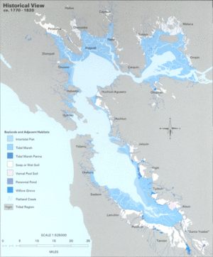
Before European settlers arrived, most of the San Francisco Bay shores were covered in tidal marshes. These are a type of wetland where water levels change with the tides. Sadly, about 85% of these marshes have been lost or destroyed. However, about 50 marshes and parts of marshes still remain.
In the Delta area, many marshes were drained to create farmland. In San Francisco, marshes were filled in to build cities. In the East Bay, some areas were used as landfills. In the South Bay, large areas became commercial salt evaporation ponds, where salt is collected from seawater.
Good news! Some wetlands have been restored or protected. Success stories include Eastshore State Park and Crissy Field. Many native and recovered wetlands are now protected in places like the Don Edwards San Francisco Bay National Wildlife Refuge and the San Pablo Bay National Wildlife Refuge.
Wetlands also exist along the Pacific Coast, like the Estero Americano. You can also find them in some inland valleys, such as the Laguna de Santa Rosa near Santa Rosa.
Transportation: Waterways for Travel
The Bay Area is a huge natural harbor, which means it's a great place for ships to dock. Because of this, many seaports and naval facilities have grown up around it.
Today, active ports include those in Richmond, Redwood City, San Francisco, and Oakland. Ships also travel through the bay to reach ports in Stockton and Sacramento.
During World War I and World War II, this region was a major shipbuilding center for the United States on the Pacific coast. Some former naval facilities include Point Molate Naval Fuel Depot, Alameda Point Naval Facility, and Mare Island Naval Shipyard.
Many Bay Area cities have marinas, which are places where boats can be docked. Examples include the Berkeley, Petaluma, and Redwood City marinas.
There's also a large system of commuter ferries that help people travel across the bay. This system is being expanded by the San Francisco Bay Water Transit Authority.
On the Pacific Coast, harbors for ocean-going vessels have been built at Bodega Bay and Half Moon Bay.
 | Sharif Bey |
 | Hale Woodruff |
 | Richmond Barthé |
 | Purvis Young |


