Berkeley Marina facts for kids
Quick facts for kids
Berkeley Marina
|
|
|---|---|
|
Neighborhood of Berkeley
|
|

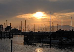
The Berkeley Marina during sunset
|
|
| Country | United States |
| State | California |
| County | Alameda |
| City | Berkeley |
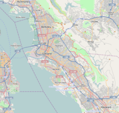
The Berkeley Marina is a cool spot in the city of Berkeley, California. It's the part of the city that stretches furthest west into the San Francisco Bay. You can find it right off University Avenue, just west of the main freeway (Interstate 80 and 580).
When people say "Berkeley Marina," they often mean the whole area. This includes the actual marina where boats are docked. It's a great place to visit!
At the Berkeley Marina, you'll find several restaurants and even a hotel. There's also a yacht club for boat owners. If you love being outdoors, you'll enjoy the many paths for walking and biking.
You can easily get to the Marina from other parts of Berkeley. Just walk or bike over the Berkeley I-80 Bridge. This bridge is at the end of Addison Street. A part of the San Francisco Bay Trail also runs through the area. This trail is perfect for long walks or bike rides along the Bay.
Some special AC Transit buses (Route 51B) also go to the Marina. The eastern edge of the Marina is now part of the beautiful Eastshore State Park.
Contents
Exploring the History of Berkeley Marina
The area we now call the Berkeley Marina used to be part of the open waters of San Francisco Bay. Over many years, people gradually filled in this part of the Bay. The original shoreline was much further east.
Building the Berkeley Pier
In 1909, the city of Berkeley built a large dock, called a municipal wharf. It was mainly used for moving goods. Then, in 1926, a company started building the Berkeley Pier. This pier stretched about 3.5 miles (5.6 km) into the Bay from the original shoreline.
On June 16, 1927, car ferries began running from the Berkeley Pier. They took cars and people across the Bay to San Francisco. This ferry service was very important for travel. A major road, U.S. Route 40, even led right to the pier.
The ferry service stopped around 1937. This was because the San Francisco–Oakland Bay Bridge had opened in 1936. After that, the pier became a popular spot for fishing. Storms damaged the pier over time, and it was closed. But it was repaired after World War II and reopened in 1946 for fishing. The city fixed parts of it again in the 1970s. It was used for fishing and sightseeing until 2015.
From Dump to Park
Since the late 1920s, the city's main dump was located here. All the trash and building materials helped create most of the dry land at the Berkeley Marina. In the early 1990s, a big part of this old dump was turned into a park. It was first called "North Waterfront Park."
In 1996, the park was renamed Cesar Chavez Park. This was to honor a famous California labor leader. Today, it's a lovely green space for everyone to enjoy.
Creating the Yacht Harbor
The actual Berkeley Marina, where many people keep their boats, was built in the late 1930s. It was first called the Berkeley Yacht Harbor. This project was part of the Works Progress Administration (WPA). The WPA was a government program that created jobs during the Great Depression. They also worked on nearby Aquatic Park.
During World War II, the United States Navy used the Berkeley Yacht Harbor. They built tugboats there to help with the war effort.
The Berkeley Heliport
From October 1961 to April 1974, there was a heliport at the Marina. A heliport is like an airport, but for helicopters! It was located on the north side of University Avenue.
A company called SFO Helicopter Airlines operated from here. They flew passengers to the San Francisco (SFO) and Oakland (OAK) international airports. They used large helicopters like the Sikorsky S-61 and Sikorsky S-62. This heliport is no longer there today.
 | William L. Dawson |
 | W. E. B. Du Bois |
 | Harry Belafonte |


