
Grand Mound, Washington facts for kids
Quick facts for kids
Grand Mound
|
|
|---|---|

Town sign for Grand Mound, located at main intersection
|
|

Location of Grand Mound, Washington
|
|
| Country | United States |
| State | Washington |
| County | Thurston |
| Settled | 1851 |
| Area | |
| • Total | 3.93 sq mi (10.2 km2) |
| • Land | 3.93 sq mi (10.2 km2) |
| • Water | 0.0 sq mi (0 km2) |
| Elevation | 167 ft (51 m) |
| Population
(2020)
|
|
| • Total | 3,301 |
| • Density | 839.9/sq mi (324.3/km2) |
| Time zone | UTC-8 (Pacific (PST)) |
| • Summer (DST) | UTC-7 (PDT) |
| ZIP codes |
98531, 98579
|
| Area code(s) | 360, 564 |
| FIPS code | 53-27890 |
| GNIS feature ID | 1512250 |
| Elevation | |
Grand Mound is a community in Thurston County, Washington, in the United States. It's also called a "census-designated place" (CDP). This means it's an area that looks like a town but isn't officially a city.
A man named Jotham Weeks Goodell founded Grand Mound in 1851. His daughter was Phoebe Judson. In 2020, about 3,301 people lived there. Grand Mound uses the zip codes 98579 and 98531. These zip codes also cover nearby places like Rochester and Gate.
Contents
Grand Mound's Early History
Grand Mound was started in 1851. Stagecoach service, like an old bus, began in 1854. The community was first known as Mound Prairie.
Fort Henness: A Historic Defense
In the mid-1800s, people in Mound Prairie built Fort Henness. This fort had two strong blockhouses. They built it because they were worried about attacks during the Puget Sound War. However, the fort was never actually used in a battle.
Maple Lane School for Girls
In 1913, the Washington State School for Girls was created. It opened in 1914 on a large piece of land. This school was later renamed Maple Lane School in 1959. It helped young girls and closed down in 2011.
Farming and the Great Depression
In the 1920s, strawberries became a very important crop in the area. A factory was even built to process them. But during the Great Depression, the strawberry business struggled. The Northern Pacific Railway also closed its train station in Grand Mound. By 1941, about 200 people lived in the area. It had a post office, a store, and one gas station.
Fire and Emergency Services
On November 6, 1962, people voted to create Thurston County Fire Protection District No. 14. This group helped put out fires and later provided medical help. They started working from an old gas station in 1963. Later, they built a new fire station on the same spot in 1971.
In 1979, voters approved money to build another fire station. They also added four new bays to the main station in Grand Mound. In 2000, voters approved more money for a new station and a new water tender truck. In 2002, Fire District No. 14 joined with Fire District No. 1. They became the Grand Mound - Rochester Fire Department. A new fire station for Grand Mound was built in 2007. This was paid for by money voters approved in 2006. In 2009, more fire districts joined together. They formed the West Thurston Regional Fire Authority in 2010.
Grand Mound Becomes a CDP
Grand Mound officially became a census-designated place (CDP) in 1990.
Great Wolf Lodge Opens
In March 2008, a large hotel called Great Wolf Lodge opened in Grand Mound. It has 398 rooms and a big indoor water park. The Confederated Tribes of the Chehalis Reservation owned most of it.
Grand Mound's Geography
Grand Mound is located in the southern part of Thurston County. It is close to the border with Lewis County. The community is just north of Centralia.
Major Roads and Highways
Two important roads pass through Grand Mound. These are Interstate 5 and U.S. Route 12. U.S. Route 12 leaves Interstate 5 at the Grand Mound exit. It then heads west towards Grays Harbor.
Land and Water Features
Grand Mound covers about 3.93 square miles of land. It sits on Grand Mound Prairie. This prairie was named after a 125-foot tall, tree-covered hill. This hill was the biggest of several similar mounds in the area.
Prairie Creek is the only stream within Grand Mound's boundaries. It flows into the nearby Chehalis River. The two rivers meet southwest of the town. Scatter Creek is just north of Grand Mound. It flows west through the Scatter Creek Wildlife Recreation Area. It then meets the Chehalis River south of Rochester.
Scatter Creek Wildlife Area
North of Grand Mound is the Scatter Creek Unit. This is a 915-acre wildlife reserve. It protects one of the last remaining areas of south Puget Sound prairie.
Grand Mound's Population
| Historical population | |||
|---|---|---|---|
| Census | Pop. | %± | |
| 1990 | 1,394 | — | |
| 2000 | 1,948 | 39.7% | |
| 2010 | 2,981 | 53.0% | |
| 2020 | 3,301 | 10.7% | |
| U.S. Decennial Census 2020 Census |
|||
In 2000, there were 1,948 people living in Grand Mound. There were 687 households, which are groups of people living together. About 529 of these were families. The population density was about 621 people per square mile.
Many different groups of people live in Grand Mound. In 2000, about 88% of the people were White. About 10% of the population was Hispanic or Latino.
The average age of people in Grand Mound in 2000 was 33 years old. About 29% of the people were under 18 years old.
Arts and Culture in Grand Mound
Grand Mound has several places that tell about its past.
Historic Markers and Sites
- A historical marker in Grand Mound celebrates an important event. It remembers when the women of the town successfully voted in Washington territorial elections.
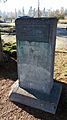
- Just south of Grand Mound, on Old Highway 99, there is an Oregon Trail marker. This marker was put there in 1916 by the Daughters and Sons of the American Revolution.
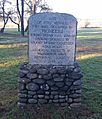
- A monument across from Grand Mound Cemetery shows where Fort Henness used to be. This was the fort built during the Puget Sound War of 1855-56.
Parks and Recreation
The South Sound Speedway is located just northeast of Grand Mound's main area. It is a racetrack where people can watch Figure 8 car races.
Images for kids
-
Oregon Trail marker
-
Ft. Henness monument
-
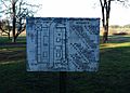
Ft. Henness layout


See also
 In Spanish: Grand Mound (Washington) para niños
