Capitol Peak (Thurston County) facts for kids
Quick facts for kids Capitol Peak |
|
|---|---|
 |
|
| Highest point | |
| Elevation | 2,664 ft (812 m) NAVD 88 |
| Prominence | 433 ft (132 m) |
| Geography | |
| Location | Thurston County, Washington, U.S. |
| Parent range | Black Hills |
| Topo map | USGS Capitol Peak |
Capitol Peak is a special mountain located in the Black Hills area of Washington state, in the U.S.. It stands out as the highest point in the Black Hills, offering amazing views from its top. This peak is part of the beautiful Capitol State Forest, a popular place for outdoor adventures.
Contents
Getting to the Top
You can reach the summit of Capitol Peak by using a road called Sherman Valley Road. This road is partly paved, making it easier to drive up. It's a fun journey to the top, especially if you enjoy scenic drives.
What's at the Summit?
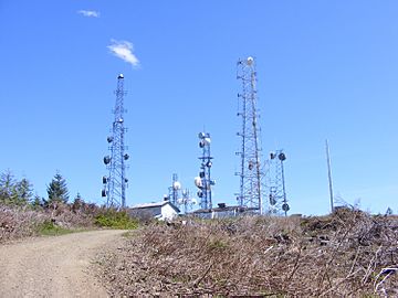
The very top of Capitol Peak is home to a communications facility. This means you'll see many cell phone and radio towers there. These towers help people communicate across the region, making sure your phones and radios work!
Amazing Views from Capitol Peak
One of the best things about Capitol Peak is the incredible scenery you can see from its summit. On a clear day, the views stretch out for miles in every direction.
Looking West
If you look towards the west from Capitol Peak, you can see the town of Elma. You might also spot the Satsop Nuclear Power Plant in the distance. It's interesting to see how far you can look from such a high point!
Looking East
Turning your gaze to the east, you'll be treated to even more spectacular sights. You can often see several famous volcanoes, including Mount Rainier, Mount St. Helens, and Mount Adams. The sparkling waters of the Puget Sound are also visible, along with the city of Olympia. It's like seeing a giant map of Washington state spread out before you!
 | Calvin Brent |
 | Walter T. Bailey |
 | Martha Cassell Thompson |
 | Alberta Jeannette Cassell |

