
Duwamish River facts for kids
Quick facts for kids Duwamish River |
|
|---|---|

The lower Duwamish Waterway and the First Avenue South Bridge (State Route 99), looking north. Slips 1, 2, and 3 can be seen on the eastern bank. Kellogg Island is the crescent-shaped island in the upper right portion. Terminal 115 is located in the central portion
|
|

Map of the Duwamish/Green River watershed with the Duwamish highlighted
|
|
| Country | United States |
| State | Washington |
| Cities | Seattle, Tukwila |
| Physical characteristics | |
| Main source | Green River |
| River mouth | Elliott Bay |
| Length | 12 mi (19 km) |
The Duwamish River is the final 12 miles (19 km) of the Green River in Washington state. This part of the river flows through an area with many factories and businesses. Because of this, it is often called the Duwamish Waterway. It is an important river for both nature and industry.
Contents
What Does "Duwamish" Mean?
The original name for the Duwamish River comes from the Lushootseed language. The native name was Dxwdəw. The Duwamish tribe lived along this river. Their name, Dxw'Dəw?Abš, means 'People of the Inside'. Both these names were later changed to Duwamish in English.
History of the Duwamish River


For a long time, the White River and the Green River joined together near Auburn. Then, they met the Black River at Tukwila to form the Duwamish.
In 1906, a big flood changed the White River's path. It started flowing into the Puyallup River instead. The part of the White River that used to join the Green River is now considered part of the Green River.
Later, in 1911, the Cedar River was moved to flow into Lake Washington. Before this, Lake Washington also flowed into the Black River. But when the Lake Washington Ship Canal opened in 1916, the lake's water level dropped a lot. This caused the Black River to dry up completely. Since then, the Green River simply becomes the Duwamish River at the same spot where it used to meet the Black River.
The Duwamish Waterway flows into Elliott Bay in Seattle. In 1909, a human-made island called Harbor Island was built. This split the river's mouth into two channels: the East and West Waterways.
Early Life Along the River
When the first European-Americans arrived in 1851, they found the Dkhw’Duw’Absh people living in many villages along the river. Scientists have found old items that show these tribes lived there since at least the 6th century AD. The Dkhw’Duw’Absh people used the river for hunting ducks and geese. They also fished for salmon, cod, and halibut. They gathered clams, berries, and other plants for food and medicine.
Over time, new settlements and businesses took over the native villages. By the early 1900s, most of the traditional ways of life along the river had disappeared.
Shaping the River for Industry
In 1895, Eugene Semple, a former Governor of Washington Territory, suggested big projects for Seattle. One idea was to make the Duwamish River straighter and deeper. This would help businesses and stop floods. In 1909, Seattle created the Duwamish Waterway Commission. Their job was to manage the river's re-channeling.
Work started in October 1913. The curvy parts of the river were gradually removed. Some small areas were left for high water and turning ships. Neighborhoods like Georgetown and South Park that were once by the river found themselves farther inland. For example, the Georgetown Steam Plant ended up almost a mile from the river. Special pumps were needed to get water to it.
By 1920, about 4.5 miles of the Duwamish Waterway were dug to a depth of 50 feet. About 20 million cubic feet of mud and sand were used to make Harbor Island bigger. The river, which used to be shallow and winding for nine miles, became a five-mile-long waterway. It was now deep enough for large ocean ships.
Industrial Growth and Bridges
After these changes, the Duwamish area became a major center for industry and business in Seattle. Many activities took place here, such as:
- Handling and storing cargo
- Building ships and boats
- Making concrete and paper
- Processing food
- And many other factory operations
Boeing Plant 1 was built on the Lower Duwamish in 1916. Boeing Plant 2 was built further upriver in 1936.
Four main public bridges cross the lower waterway:
- The First Avenue South Bridge
- The South Park Bridge
- The Spokane Street Bridge
- The West Seattle Bridge (which is directly above the Spokane Street Bridge)
Protecting the River Today
In the 1970s, people became more aware of environmental issues. Many groups, including environmentalists, tribes, and local communities, became concerned about the Duwamish River's pollution. Kellogg Island, which is a small piece of the original river, was made a wildlife preserve. A nearby area, Terminal T-107, was turned into a park. These efforts created a natural space near the river's mouth. Cleanup and restoration work are still happening today.
In 2009, the Duwamish Longhouse and Cultural Center opened on the west bank of the river. This center helps the Duwamish tribe share their history and continue their efforts to gain official recognition.
Pollution in the Duwamish River


Because of industrial pollution in the 1900s, the lower 5 miles (8.0 km) of the Duwamish River was named a Superfund site. This means it is a very polluted place that needs a special cleanup plan. The pollution includes harmful chemicals like:
Cleaning up the river has been a big discussion. One early plan suggested digging up the polluted mud and dumping it in Tacoma's Commencement Bay. This plan was not popular in Seattle or Tacoma. So, the polluted mud was instead sent to Klickitat County in south central Washington.
The full cleanup plan for the whole river was shared in 2013. A group called the Duwamish River Cleanup Coalition/Technical Advisory Group reviewed the plan. They shared their ideas and suggestions for making the cleanup even better.
Besides these chemicals, the Duwamish River faces other types of pollution. One major problem is bacteria from sewage overflow. Even if these overflows were stopped, the water quality would still need improvement. The most common pollutant in the Duwamish River is petroleum (oil). Other pollution also comes from farms, rainwater runoff, and broken septic tanks.
Wildlife in the Duwamish River
Even with all the industry, the Duwamish River is still a vital home for thousands of salmon and trout. These fish visit the river's marshes and estuaries each year to lay their eggs. The Duwamish supports several types of salmon, including:
- Chinook
- Coho
- Chum
- Steelhead
Rarer fish like sockeye, sea-run cutthroat trout, and bull trout also live here. Pink salmon also come in huge numbers every other year.
However, many animals living in or around the river have unhealthy amounts of pollutants in their bodies. For example, most fish and shellfish from the river (except salmon) are not safe for people to eat. Studies found that PCB levels in fish and crabs that live in the waterway are much higher than in salmon from Puget Sound. It was also found that river otters in the Lower Duwamish River might be exposed to so many PCBs that it could affect the growth or survival of their babies.
Images for kids
-
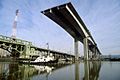
West Seattle Bridge under construction circa 1983

See also
 In Spanish: Río Duwamish para niños
