
Auburn, Washington facts for kids
Quick facts for kids
Auburn, Washington
|
|||
|---|---|---|---|

Downtown Auburn in 2018, seen from the train station's parking garage
|
|||
|
|||
| Nickname(s):
A-town
|
|||
| Motto(s):
"More Than You Imagined"
|
|||

Location of Auburn in King County
|
|||
| Country | United States | ||
| State | Washington | ||
| Counties | King, Pierce | ||
| Incorporated | June 13, 1891 | ||
| Named for | Auburn, New York | ||
| Government | |||
| • Type | Mayor–council | ||
| Area | |||
| • Total | 29.87 sq mi (77.35 km2) | ||
| • Land | 29.58 sq mi (76.60 km2) | ||
| • Water | 0.29 sq mi (0.75 km2) | ||
| Elevation | 82 ft (25 m) | ||
| Population
(2020)
|
|||
| • Total | 87,256 | ||
| • Estimate
(2023)
|
83,870 | ||
| • Rank | US: 422nd WA: 15th |
||
| • Density | 2,836.04/sq mi (1,095.01/km2) | ||
| Time zone | UTC−8 (Pacific (PST)) | ||
| • Summer (DST) | UTC−7 (PDT) | ||
| ZIP Codes |
98001, 98002, 98003, 98023, 98047, 98063, 98071, 98092, 98093
|
||
| Area code(s) | 253 | ||
| FIPS code | 53-03180 | ||
| GNIS feature ID | 1511974 | ||

Auburn is a city in Washington state, located mostly in King County. A small part of the city is in Pierce County. In 2020, about 87,256 people lived there.
Auburn is a suburb of Seattle, a larger city nearby. It is the 15th largest city in Washington. The Muckleshoot Indian Reservation is located just south and southeast of Auburn.
Contents
History of Auburn

.jpeg)
Before the 1850s, the Muckleshoot people lived in the Green River Valley. European settlers arrived in the 1860s. One settler, Levi Ballard, started a farm between the Green and White rivers.
In 1886, Ballard officially planned a town. He named it Slaughter, after an officer who died in a conflict in 1855. The town of Slaughter became an official city on June 13, 1891.
However, people didn't like the name "Slaughter." The town's hotel was even called the "Slaughter House"! So, in 1893, the name was changed to Auburn. It was named after Auburn, New York, because both towns grew a plant called hops.
The White and Green Rivers have always been important to Auburn. But they also caused many floods. People even created Mountain View Cemetery on a hill to avoid the floods. Later, the Mud Mountain Dam and Howard A. Hanson Dam were built. These dams stopped the flooding, helping the city grow.
In 1917, Auburn gave land in Pioneer Cemetery to the White River Buddhist Church. Japanese-American baseball teams from the area were very successful. In 1930, a Japanese bath house was built near Neely Mansion.
During World War II, many Japanese-American families in Auburn were forced to leave their homes. They were sent to special camps because of Executive Order 9066. This happened in 1942. After the war, only about 25 out of 300 Japanese families returned to Auburn. Later, in 1980, a government group said this was unfair.
In 2008, Auburn grew by adding the West Hill and Lea Hill areas. This added 15,000 new residents to the city.
Geography of Auburn
Auburn covers about 29.87 square miles (77.35 square kilometers). Most of this is land, with a small amount of water.
Two rivers flow through Auburn: the White River and the Green River.
Long ago, another river called the Stuck River ran through the area. In 1906, the White River was redirected into the Stuck's path. Today, the Stuck River is mostly part of the White River.
Neighborhoods in Auburn

Auburn has many different neighborhoods:
- Downtown—This area has old buildings and traditional streets. It also has many Craftsman-style houses from the 1920s.
- North Auburn—This area has both businesses and homes.
- River's Bend—A small group of homes along the Green River.
- Christopher/Thomas—These were once farming towns. They became part of Auburn in the 1960s.
- Lea Hill—Mostly homes, this area joined Auburn in 2007. Green River College is located here.
- Hazelwood—This area is on Lea Hill. It was a town in the late 1800s.
- West Valley—An area with businesses and factories.
- West Hill—Located on a hill, next to the city of Federal Way.
- South Auburn—An area south of downtown that is becoming a business zone.
- Terminal Park—Homes for railroad workers, near the rail yard.
- Forest Villa—Mostly homes near Game Farm Park.
- Lakeland Hills—A large planned community on a hillside. It is in both King and Pierce counties.
- Hidden Valley—A planned community overlooking North Lake Tapps.
Auburn's Climate
| Climate data for Auburn, Washington | |||||||||||||
|---|---|---|---|---|---|---|---|---|---|---|---|---|---|
| Month | Jan | Feb | Mar | Apr | May | Jun | Jul | Aug | Sep | Oct | Nov | Dec | Year |
| Record high °F (°C) | 64 (18) |
71 (22) |
81 (27) |
86 (30) |
92 (33) |
100 (38) |
99 (37) |
99 (37) |
96 (36) |
86 (30) |
74 (23) |
69 (21) |
100 (38) |
| Mean daily maximum °F (°C) | 47 (8) |
51 (11) |
55 (13) |
61 (16) |
67 (19) |
72 (22) |
77 (25) |
78 (26) |
72 (22) |
62 (17) |
52 (11) |
46 (8) |
62 (17) |
| Mean daily minimum °F (°C) | 35 (2) |
36 (2) |
39 (4) |
42 (6) |
47 (8) |
52 (11) |
55 (13) |
55 (13) |
51 (11) |
44 (7) |
39 (4) |
35 (2) |
44 (7) |
| Record low °F (°C) | −10 (−23) |
−5 (−21) |
10 (−12) |
25 (−4) |
27 (−3) |
33 (1) |
38 (3) |
34 (1) |
28 (−2) |
24 (−4) |
−1 (−18) |
3 (−16) |
−10 (−23) |
| Average precipitation inches (mm) | 5.3 (130) |
4.5 (110) |
4.1 (100) |
2.9 (74) |
2.1 (53) |
1.7 (43) |
0.9 (23) |
1.2 (30) |
1.8 (46) |
3.4 (86) |
6.1 (150) |
5.8 (150) |
37.1 (940) |
| Source: Weather.com | |||||||||||||
People in Auburn
| Historical population | |||
|---|---|---|---|
| Census | Pop. | %± | |
| 1890 | 740 | — | |
| 1900 | 489 | −33.9% | |
| 1910 | 957 | 95.7% | |
| 1920 | 3,163 | 230.5% | |
| 1930 | 3,906 | 23.5% | |
| 1940 | 4,211 | 7.8% | |
| 1950 | 6,497 | 54.3% | |
| 1960 | 11,933 | 83.7% | |
| 1970 | 21,653 | 81.5% | |
| 1980 | 26,417 | 22.0% | |
| 1990 | 33,102 | 25.3% | |
| 2000 | 40,314 | 21.8% | |
| 2010 | 70,180 | 74.1% | |
| 2020 | 87,256 | 24.3% | |
| 2023 (est.) | 83,870 | 19.5% | |
| U.S. Decennial Census 2020 Census |
|||
In 2023, there were about 30,938 households in Auburn. Each household had about 2.74 people. The average household income was $92,824. About 9.6% of people in Auburn live below the poverty line.
Most people in Auburn have a high school diploma (88.9%). About 26.2% have a college degree or higher.
Many people in Auburn have German (11.6%), English (9.3%), or Irish (5.9%) backgrounds. The average age in the city is 36.6 years old.
Population Changes (2020 Census)
| Race / ethnicity (NH = non-Hispanic) | Pop. 2000 | Pop. 2010 | Pop. 2020 | % 2000 | % 2010 | % 2020 |
|---|---|---|---|---|---|---|
| White alone (NH) | 32,220 | 45,954 | 42,367 | 79.92% | 65.48% | 48.55% |
| Black or African American alone (NH) | 956 | 3,338 | 6,576 | 2.37% | 4.76% | 7.54% |
| Native American or Alaska Native alone (NH) | 953 | 1,413 | 1,492 | 2.36% | 2.01% | 1.71% |
| Asian alone (NH) | 1,389 | 6,178 | 11,312 | 3.45% | 8.80% | 12.96% |
| Pacific Islander alone (NH) | 197 | 1,137 | 2,719 | 0.49% | 1.62% | 3.12% |
| Other race alone (NH) | 52 | 99 | 469 | 0.13% | 0.14% | 0.54% |
| Mixed race or multiracial (NH) | 1,528 | 3,029 | 6,096 | 3.79% | 4.32% | 6.99% |
| Hispanic or Latino (any race) | 3,019 | 9,032 | 16,225 | 7.49% | 12.87% | 18.59% |
| Total | 40,314 | 70,180 | 87,256 | 100.00% | 100.00% | 100.00% |
In 2020, Auburn had 87,256 people. There were 30,806 households. The city's population density was about 2950 people per square mile.
The population was made up of different groups:
- 51.60% White
- 7.79% African American
- 2.29% Native American
- 13.11% Asian
- 3.17% Pacific Islander
- 10.32% from other races
- 11.72% from two or more races
About 18.59% of the population was Hispanic or Latino. About 24.9% of residents were under 18 years old.
Economy and Jobs
Jobs in Auburn
As of August 2024, about 69.2% of people in Auburn have jobs. The unemployment rate was 5.2%.
The Boeing Plant in Auburn opened in 1966. It is the world's largest factory for airplane parts. It makes 1.265 million parts each year. Over 5,000 people work there. Boeing is the third biggest employer in Auburn.
The Northwest headquarters for the United States General Services Administration is also in Auburn.
Top Employers in Auburn
Here are the largest employers in Auburn:
| # | Employer | What they do | Number of Employees | Percentage |
|---|---|---|---|---|
| 1 | The Boeing Company | Aerospace (planes) | 3,600 | 8.8% |
| 2 | Auburn School District No. 408 | Education (schools) | 2,536 | 6.2% |
| 3 | Muckleshoot Tribal Enterprises | Gaming (casinos) | 1,472 | 3.6% |
| 4 | MultiCare Auburn Medical Center | Hospital | 1,208 | 3.0% |
| 5 | Green River College | Education (college) | 857 | 2.1% |
| 6 | Safeway Distribution Center | Distributing goods | 800 | 2.0% |
| 7 | Costco Wholesale Optical #190 | Distributing goods | 782 | 1.9% |
| 8 | City of Auburn | City government | 574 | 1.4% |
| 9 | Ply Gem Pacific Windows Corp | Manufacturing (windows) | 550 | 1.3% |
| 10 | Walmart Supercenter #2385 | Retail (store) | 336 | 0.8% |
Shopping in Auburn
The Outlet Collection Seattle is a large outlet mall in Auburn. It opened in 1995.
Arts and Culture
The White River Valley Museum in Auburn shows the area's history. You can learn about the Muckleshoot Indian Tribe and early settlers. It also covers Japanese immigration, farming, and railroads. You can see a pioneer cabin and a train caboose.
Auburn has a large public library that is part of the King County Library System. It is 20,000 square feet and was expanded in 2012. The library is in Les Gove Park. This park also has the White River Valley Museum and a senior center. Many celebrations, like the Fourth of July, happen in Les Gove Park.
Auburn is a special place for Veterans Day celebrations. The US Department of Veterans Affairs chose it as a Regional Site.
Important Landmarks
The City of Auburn has named these buildings as landmarks:
| Landmark | Built | Listed | Photo |
|---|---|---|---|
| Auburn Masonic Temple | 1923–24 | 2002 |  |
| Auburn Post Office | 1937 | 2000 |  |
| Auburn Public Library | 1914 | 1995 |  |
Sports

Emerald Downs is a large stadium and thoroughbred horse racetrack. It covers 167 acres. The Muckleshoot tribe bought the land in 2002.
Parks and Recreation
Auburn has many parks and open spaces. There are 28 developed parks. The city also has over 23 miles of trails for biking, walking, and skating. This includes 4.5 miles of the Inter-urban Trail. There are also almost 247 acres of open space for outdoor fun.
Education

Public schools in Auburn are managed by the Auburn School District. This district also serves nearby towns like Algona and Pacific. Some parts of Auburn are served by the Federal Way and Kent school districts.
High Schools in Auburn
- Auburn High School
- Auburn Mountainview High School
- Auburn Riverside High School
- Auburn Adventist Academy
- West Auburn High School
Elementary and Middle Schools
- Arthur Jacobsen Elementary
- Bowman Creek Elementary
- Cascade Middle School
- Chinook Elementary
- Dick Scobee Elementary
- Evergreen Heights Elementary
- Gildo Rey Elementary
- Hazelwood Elementary
- Ilalko Elementary
- Lake View Elementary
- Lakeland Hills Elementary
- Lea Hill Elementary
- Mt. Baker Middle School
- Olympic Middle School
- Pioneer Elementary
- Rainier Middle School
- Terminal Park Elementary
- Washington Elementary
- Willow Crest Elementary
Private and Alternative Schools
- Auburn Adventist Academy
- Rainier Christian High School
- Valley Christian School
- Holy Family School
- Auburn Online
College
- Green River College
Transportation

Auburn has important roads like State Route 167 and State Route 18. The city also has its own transit center, Auburn station, in downtown. This station is a main hub for southern King County.
Buses connect Auburn Transit Center to Federal Way, Sumner, and Kent. Other buses go to Green River Community College, The Outlet Collection Seattle, and Auburn Way.
Sounder commuter trains travel from Auburn to Downtown Seattle in about 30 minutes. They also go to Lakewood station in less than 35 minutes.
Auburn used to have a large train yard for the Northern Pacific Railway. Today, BNSF Railway still uses a rail yard there for train repairs. The Auburn Municipal Airport is also available for small planes.
Notable People from Auburn
- Harrison Maurus, a weightlifter who won a bronze medal.
- Nate Cohn, a journalist and expert on public opinion polls.
- Janna Crawford, a Paralympic athlete who won a gold medal.
- Cam Gigandet, an actor.
- Christine Gregoire, who was the 22nd governor of Washington.
- Greg Haugen, a professional boxer.
- Eric Barone, a video game designer known as ConcernedApe.
- Gordon Hirabayashi, a civil rights activist.
- Ariana Kukors, an Olympic swimmer and world record holder.
- Evan McMullin, a former CIA officer.
- Sir Mix-A-Lot, a hip hop artist.
- Blair Rasmussen, a former NBA basketball player.
- Dave Reichert, a former sheriff and U.S. Congressman.
- Diane Schuur, a jazz singer and pianist.
- Francis R. "Dick" Scobee, a NASA astronaut.
- Danny Shelton, an NFL football player.
- Minoru Yamasaki, a famous architect.
Sister Cities
Auburn has five sister cities around the world:
 Tamba, Japan
 Pyeongchang, South Korea
 Guanghan, China
- Yuhang, China
 Mola di Bari, Italy
Auburn and Tamba, Japan, have a yearly student exchange program. Students from both cities visit each other.
Images for kids
-
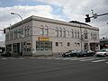
Auburn Masonic Temple
-
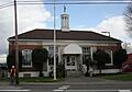
Auburn Post Office
-
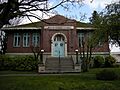
Auburn Public Library
See also
 In Spanish: Auburn (Washington) para niños
