
Half Moon Island facts for kids

Half Moon Island from Kuzman Knoll, Livingston Island, with Greenwich Island in the background
|
|
 |
|

Half Moon Island
Location in Antarctic Peninsula

Half Moon Island
Location in Antarctica
|
|
| Geography | |
|---|---|
| Location | Antarctica |
| Coordinates | 62°35′24″S 59°54′36″W / 62.59000°S 59.91000°W |
| Archipelago | South Shetland Islands |
| Area | 171 ha (420 acres) |
| Administration | |
| Administered under the Antarctic Treaty System | |
| Demographics | |
| Population | Uninhabited |

Half Moon Island is a small island in Antarctica. It is part of the South Shetland Islands, located about 1.35 kilometers (0.84 miles) north of Livingston Island. The island covers an area of about 171 hectares.
Argentina has a science base on the island called Cámara Base. You can only reach Half Moon Island by boat or helicopter, as there are no airports. The science base is open sometimes in summer for researchers, but it closes during the cold winter months.
Contents
Island Geography
Half Moon Island is made of gravel beaches that connect small rocky islands. These rocky parts are from old volcanoes that erupted millions of years ago. The island's curved shape, like a half moon, might be from an ancient volcano that collapsed. The parallel gravel beaches formed after the huge ice caps from the last Ice Age melted, causing the land to slowly rise.
Amazing Antarctic Wildlife
Half Moon Island is a special place for wildlife. It has been named an Important Bird Area (IBA) by BirdLife International. This means it's a very important spot for birds to live and raise their young.
Plants on the Island
Even though it's cold, some plants grow here! You can find different types of lichen and moss. There's also a plant called Antarctic Hairgrass.
Birds of Half Moon Island
Many birds come to Half Moon Island to nest.
- Chinstrap penguins: About 2,000 pairs of these penguins live here.
- South polar skuas: Around 100 pairs of these large birds nest on the island.
- Antarctic terns: About 125 pairs of these graceful birds can be seen.
- Kelp gulls: Around 40 pairs of gulls make their homes here.
- Other birds include Wilson's storm-petrels, black-bellied storm petrels, Cape petrels, brown skuas, snowy sheathbills, and imperial shags.
Seals and Whales
You can often see seals resting on the beaches of Half Moon Island.
- Weddell seals and Antarctic fur seals regularly come ashore.
- Sometimes, Southern elephant seals are also spotted.
- Whales are often seen swimming near the island's shores.

Visiting Half Moon Island
Many tourist ships stop at Half Moon Island during Antarctic cruises. The busiest time for visitors is from November to March.
There's a 2,000-meter (2,187-yard) walking path on the southern part of the island. This path lets tourists get a close look at the amazing wildlife, especially the chinstrap penguins and skuas. You can also enjoy the beautiful mountain views of nearby Livingston Island and Greenwich Island. The path starts at Menguante Cove, goes along the beach to Cámara Base, then turns north, and finally goes up to the top of Xenia Hill.
Half Moon Island on Google Street View
In 2010, Google added Google Street View images of Half Moon Island to Google Earth and Google Maps. This meant that all seven continents now had Street View images! Since the island has no roads, the pictures were taken with a special camera on a tripod. If you look closely, you might even see the shadow of the photographer! For a while, the usual Pegman icon on Google Maps was changed to a penguin when viewing Half Moon Island, because of all the penguins that live there.
Maps of the Area
- L.L. Ivanov et al., Antarctica: Livingston Island and Greenwich Island, South Shetland Islands (from English Strait to Morton Strait, with illustrations and ice-cover distribution), 1:100000 scale topographic map, Antarctic Place-names Commission of Bulgaria, Sofia, 2005
- L.L. Ivanov. Antarctica: Livingston Island and Greenwich, Robert, Snow and Smith Islands. Scale 1:120000 topographic map. Troyan: Manfred Wörner Foundation, 2009. ISBN: 978-954-92032-6-4
- L.L. Ivanov. Antarctica: Livingston Island and Smith Island. Scale 1:100000 topographic map. Manfred Wörner Foundation, 2017. ISBN: 978-619-90008-3-0
Gallery
-
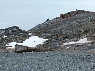
The wreck of an old whaling boat, located at the south end of Island.
-
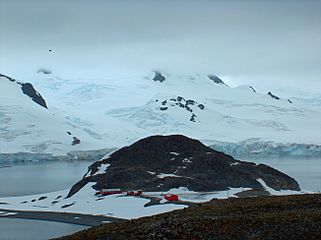
Cámara Base and Morenita Hill from Xenia Hill.
-
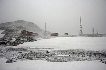
View of Cámara Base.
-
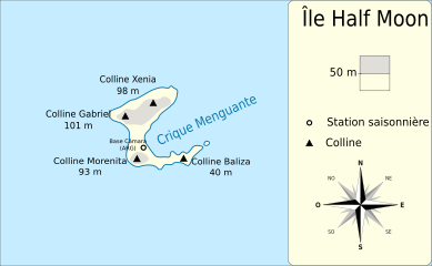
Half Moon Island map
-
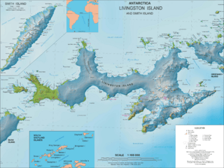
Topographic map of Livingston Island


See also
 In Spanish: Isla Media Luna para niños
