Low Island (South Shetland Islands) facts for kids

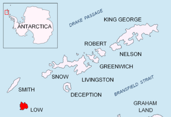
Location of Low Island in the South Shetland Islands
|
|
|
Location in the South Shetland Islands##Location in Antarctica
|
|
| Geography | |
|---|---|
| Location | Antarctica |
| Coordinates | 63°17′S 62°09′W / 63.283°S 62.150°W |
| Archipelago | South Shetland Islands |
| Length | 9 mi (14 km) |
| Width | 5 mi (8 km) |
| Administration | |
| Administered under the Antarctic Treaty System | |
| Demographics | |
| Population | 0 |
Low Island, also known as Isla Baja, is a small island in the South Shetland Islands. It is about 9 miles (14 km) long and 5 miles (8 km) wide. This island is located 14 miles (23 km) southeast of Smith Island.
You can find Low Island at 63°17′S 62°09′W / 63.283°S 62.150°W. A narrow waterway called Osmar Strait separates it from Smith Island. The island got its name because it is very flat and has a low elevation (not very high above sea level). People who hunted seals knew about Low Island as early as 1820. Its name has been used around the world for over 100 years.
Wildlife on Low Island
Low Island is a special place for Chinstrap Penguins. These penguins gather at Cape Garry on the island to breed. This area is home to the second largest colony of Chinstrap Penguins on the island. More than 100,000 pairs of penguins live and raise their young here. It's an amazing sight to see so many penguins!
More to Explore
 Learn more about Isla Baja (Shetland del Sur) in Spanish: Isla Baja (Shetland del Sur) para niños
 | Charles R. Drew |
 | Benjamin Banneker |
 | Jane C. Wright |
 | Roger Arliner Young |


