Euphrates facts for kids
Quick facts for kids Euphrates |
|
|---|---|
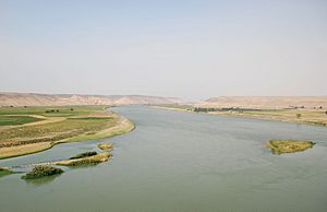
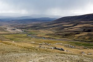
The Euphrates near Halabiye (Syria); the archaeological site Zalabiye can be seen in the background on the left bank.
|
|
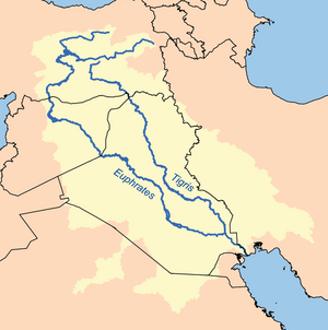
Map of the combined Tigris–Euphrates drainage basin (in yellow)
|
|
| Country | Turkey, Iraq, Syria |
| Basin area | Turkey, Syria, Iraq, Saudi Arabia, Kuwait, Iran |
| Cities | Birecik, Raqqa, Deir ez-Zor, Mayadin, Haditha, Ramadi, Habbaniyah, Fallujah, Kufa, Samawah, Nasiriyah |
| Physical characteristics | |
| Main source | Murat Su, Turkey 3,520 m (11,550 ft) |
| 2nd source | Kara Su, Turkey 3,290 m (10,790 ft) |
| River mouth | Shatt al-Arab Al-Qurnah, Basra Governorate, Iraq 31°0′18″N 47°26′31″E / 31.00500°N 47.44194°E |
| Length | 2,800 km (1,700 mi)approx. |
| Basin features | |
| Basin size | 500,000 km2 (190,000 sq mi)approx. |
| Tributaries |
|
The Euphrates is a very important river in Western Asia. It is the longest river in the region. The Euphrates flows alongside the Tigris river. Together, they are the two main rivers of Mesopotamia. This name means "Land between the Rivers."
The Euphrates starts in the Armenian Highlands in eastern Turkey. It then flows through Syria and Iraq. Finally, it joins the Tigris River to form the Shatt al-Arab. This river then empties into the Persian Gulf.
Contents
What's in a Name?
The name Euphrates comes from the Ancient Greek word Euphrátēs. This word was taken from an older Old Persian word, Ufrātu. Even older, it came from the Elamite word ú-ip-ra-tu-iš.
The Elamite name likely came from a very old writing system called cuneiform. In Sumerian, it was called "Buranuna." In Akkadian, it was "Purattu." Many cuneiform signs had both Sumerian and Akkadian names.
In Akkadian, the river was called Purattu. This name is still seen in languages like Arabic (al-Furāt) and Syriac (Pǝrāt). Some experts think the very first name for the river might have meant "copper." This is because copper was likely transported on the river long ago.
The earliest mentions of the Euphrates are in ancient texts. These texts were found in Shuruppak and Nippur in southern Iraq. They are from around 2500 BCE. In these Sumerian texts, the Euphrates was called Buranuna. Sometimes, it was even seen as a god. The ancient city of Sippar was also closely linked to the river.
Where Does the Euphrates Flow?
The Euphrates is the longest river in Western Asia. It begins where two smaller rivers meet. These are the Kara Su (Western Euphrates) and the Murat Su (Eastern Euphrates). They join together about 10 kilometres (6.2 mi) from the town of Keban in southeastern Turkey.
The total length of the Euphrates, from the Murat River to where it meets the Tigris, is about 3,000 kilometres (1,900 mi). About 1,230 kilometres (760 mi) of it is in Turkey. About 710 kilometres (440 mi) flows through Syria. The last 1,060 kilometres (660 mi) is in Iraq. The Shatt al-Arab, where the Euphrates and Tigris meet the Persian Gulf, is about 145–195 kilometres (90–121 mi) long.
Both the Kara Su and Murat Su start high up in the mountains. They begin northwest of Lake Van in Turkey. The Kara Su starts at 3,290 metres (10,790 ft) above sea level. The Murat Su starts even higher, at 3,520 metres (11,550 ft). By the time they join at the Keban Dam, the river is much lower, at 693 metres (2,274 ft).
From Keban to the Syrian border, the river drops another 368 metres (1,207 ft) in less than 600 kilometres (370 mi). Once it reaches the flat plains of Upper Mesopotamia, the river's slope becomes much gentler. In Syria, it drops 163 metres (535 ft). In Iraq, between Hīt and the Shatt al-Arab, it drops only 55 metres (180 ft).
How Much Water Flows?
The Euphrates gets most of its water from rainfall and melting snow. This means the river is fullest in April and May. During these two months, about 36 percent of the river's total yearly water flows. Sometimes, it can be as much as 60–70 percent. The river has less water in summer and autumn.
Before dams were built, the average yearly flow was about 20.9 cubic kilometres (5.0 cu mi) at Keban. It was 36.6 cubic kilometres (8.8 cu mi) at Hīt. However, the amount of water could change a lot from year to year. For example, near the Syrian border, the yearly flow ranged from 15.3 cubic kilometres (3.7 cu mi) in 1961 to 42.7 cubic kilometres (10.2 cu mi) in 1963.
The amount of water in the Euphrates has changed a lot since dams were built in the 1970s. After 1990, the average flow at Hīt dropped to 356 cubic metres (12,600 cu ft) per second. The highest flow also dropped significantly. Before 1990, the peak flow was 7,510 cubic metres (265,000 cu ft) per second. After 1990, it was only 2,514 cubic metres (88,800 cu ft) per second.
Rivers Joining the Euphrates
In Syria, three rivers join the Euphrates: the Sajur, the Balikh, and the Khabur. These rivers start in the mountains near the Syrian–Turkish border. They add a small amount of water to the Euphrates.
- The Sajur is the smallest. It flows into the reservoir of the Tishrin Dam.
- The Balikh gets most of its water from a natural spring. It flows south to meet the Euphrates at the city of Raqqa.
- The Khabur is the largest of the three. Its main springs are near Ra's al-'Ayn. It flows southeast and joins the Euphrates near Busayrah.
Once the Euphrates enters Iraq, no more natural rivers flow into it. However, there are canals that connect the Euphrates to the Tigris River.
| Name | Length | Watershed size | Discharge | Bank |
|---|---|---|---|---|
| Kara Su | 450 km (280 mi) | 22,000 km2 (8,500 sq mi) | Confluence | |
| Murat River | 650 km (400 mi) | 40,000 km2 (15,000 sq mi) | Confluence | |
| Sajur River | 108 km (67 mi) | 2,042 km2 (788 sq mi) | 4.1 m3/s (145 cu ft/s) | Right |
| Balikh River | 100 km (62 mi) | 14,400 km2 (5,600 sq mi) | 6 m3/s (212 cu ft/s) | Left |
| Khabur River | 486 km (302 mi) | 37,081 km2 (14,317 sq mi) | 45 m3/s (1,600 cu ft/s) | Left |
Euphrates River Basin
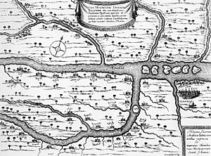
The area that collects water for the Euphrates is called its drainage basin. The Kara Su basin is about 22,000 square kilometres (8,500 sq mi). The Murat River basin is about 40,000 square kilometres (15,000 sq mi).
The total size of the Euphrates drainage basin varies in estimates. It ranges from 233,000 square kilometres (90,000 sq mi) to 766,000 square kilometres (296,000 sq mi). More recent estimates are around 388,000 square kilometres (150,000 sq mi) to 579,314 square kilometres (223,674 sq mi).
Most of the Euphrates basin is in Turkey, Syria, and Iraq. Turkey has about 28-33 percent of the basin. Syria has about 17-20 percent. Iraq has the largest share, about 40-47 percent. Some parts of the basin are also in Saudi Arabia and Kuwait. A small part of Jordan also drains towards the Euphrates.
Nature Around the Euphrates
The Euphrates flows through different vegetation zones. Over thousands of years, human activity has changed the landscape a lot. However, some areas still have their original plants. The amount of rainfall decreases as the river flows from its source to the Persian Gulf. This greatly affects what plants can grow.
In its upper parts, the Euphrates flows through mountains in Southeast Turkey. Here, you can find dry woodland. Plants like oaks, pistachio trees, and plants from the rose family grow here. Drier parts have less dense oak forests. Wild versions of many cereals, like einkorn wheat and oat, also grow here.
South of this area, there's a mix of woodland and steppe vegetation. Between Raqqa and the Syrian–Iraqi border, the Euphrates flows through a steppe. This area has plants like white wormwood. For a long time, this area has been heavily grazed by sheep and goats.
Southeast of the Syrian-Iraqi border, you find true desert. This area has very little or no vegetation. If plants grow, they are usually small desert plants. In the past, the Euphrates Valley likely had riverine forests. These forests would have included trees like the Oriental plane, Euphrates poplar, and tamarisk.
Animals of the Euphrates
The Tigris–Euphrates basin is home to many fish species. The most common are from the Cyprinidae family, with 34 out of 52 total species. One fish, the mangar, is popular for sport fishing.
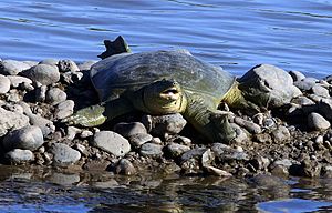
The Rafetus euphraticus is an endangered soft-shelled turtle. It lives only in the Tigris–Euphrates river system.
Ancient carvings from the Neo-Assyrian Empire show lion and bull hunts in lush landscapes. European travelers in the 16th to 19th centuries reported many animals in the Syrian Euphrates basin. Many of these animals are now rare or extinct.
Animals like gazelles, onagers, and the now-extinct Arabian ostrich lived in the steppe. The river valley itself was home to wild boars. Meat-eating animals included the gray wolf, golden jackal, red fox, leopard, and lion. The Syrian brown bear lives in the mountains of Southeast Turkey. There is also evidence that European beavers lived here long ago.
How People Use the River
The Hindiya Barrage in Iraq was the first modern structure to control the Euphrates' water. It was finished in 1913. Later, in the 1950s, the Ramadi Barrage was built. These structures help control the river's flow and send extra floodwater into Lake Habbaniyah.
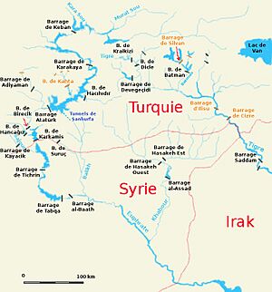
Iraq's biggest dam on the Euphrates is the Haditha Dam. It's a 9-kilometre-long (5.6 mi) earth-fill dam that created Lake Qadisiyah. Syria and Turkey also built their first dams on the Euphrates in the 1970s. Syria completed the Tabqa Dam in 1973. Turkey finished the Keban Dam in 1974.
Since then, Syria has built two more dams: the Baath Dam and the Tishrin Dam. They also plan to build a fourth, the Halabiye Dam. The Tabqa Dam is Syria's largest. Its reservoir, Lake Assad, provides important water for irrigation and drinking. Syria also built three smaller dams on the Khabur River.
Southeastern Anatolia Project (GAP)
In the 1970s, Turkey started a big project called the Southeastern Anatolia Project (GAP). This plan aims to use the waters of the Tigris and Euphrates for irrigation and electricity. It also helps the economy in southeastern Turkey.
GAP covers a huge area of 75,000 square kilometres (29,000 sq mi) and affects about 7 million people. When finished, GAP will have 22 dams and 19 power plants. It will provide water for 1,700,000 hectares (6,600 sq mi) of farmland. About 910,000 hectares (3,500 sq mi) of this land is in the Euphrates basin.
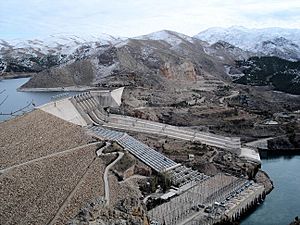
The largest dam in GAP is the Atatürk Dam. It was finished in 1992. This dam is 184-metre-high (604 ft) and 1,820-metre-long (5,970 ft). Its reservoir is the third-largest lake in Turkey. It can hold all the Euphrates' yearly water flow. The project was supposed to be done by 2010. However, it has been delayed. This is partly because there isn't a formal agreement on water sharing between Turkey and the countries downstream.
Besides dams, Iraq has built many canals. These connect the Euphrates to lakes like Lake Habbaniyah and Lake Tharthar. These lakes can store extra floodwater. The Euphrates is also connected to the Tigris by the Shatt al-Hayy canal. The largest canal is the Main Outfall Drain, also called the "Third River." It was built to drain the land between the Euphrates and Tigris south of Baghdad. This helps prevent the soil from becoming too salty from irrigation.
Impact on Nature and People
Building dams and irrigation systems on the Euphrates has greatly affected the environment and people. The dams built in Turkey as part of GAP have caused 382 villages to be flooded. Almost 200,000 people had to move. The Atatürk Dam alone displaced 55,300 people. Many of these people were not happy with their new homes or the money they received.
The flooding of Lake Assad in Syria forced about 4,000 families to move. They were relocated to other parts of northern Syria.
The dams and irrigation projects have also changed the environment in other ways. Large reservoirs in hot countries lead to more evaporation. This means less water is available for people to use. About 2 cubic kilometres (0.48 cu mi) of water evaporates from reservoirs in Turkey each year. About 1 cubic kilometre (0.24 cu mi) evaporates in Syria, and 5 cubic kilometres (1.2 cu mi) in Iraq.
Water quality in the Iraqi Euphrates is lower. This is because irrigation water from Turkey and Syria flows back into the river. This water contains dissolved fertilizers. The water in Iraq has also become saltier due to upstream dams. This makes it less suitable for drinking. The many dams and water withdrawals have also harmed the Mesopotamian Marshes and fish habitats in Iraq.
Many archaeological sites and important cultural places have been flooded. This is especially true in Turkey and Syria. People have tried hard to record or save as much as possible. However, many sites are likely lost forever. For example, the flooding of Zeugma by the Birecik Dam caused a lot of discussion. Zeugma had unique Roman mosaics.
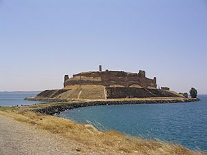
When the Tabqa Dam was built in Syria, UNESCO led a big international effort. Archaeologists from many countries dug up sites from different time periods. Two ancient towers were even moved and rebuilt outside the flood zone. Important sites like Mureybet, Emar, and Abu Hureyra were flooded. A similar effort happened when the Tishrin Dam was built. This led to the flooding of the important site of Jerf el-Ahmar.
Archaeological work was also done in the area flooded by Lake Qadisiya in Iraq. Recently, parts of this area have become dry again. This gives archaeologists new chances to study the sites. However, it also creates opportunities for valuable items to go missing.
A River Through Time
Early Human History
The earliest human settlements along the Euphrates were in its upper parts. This area is known as the Fertile Crescent. Very old stone tools from the Stone Age have been found here. Some tools found in the El Kowm oasis are 450,000 years old.
In the mountains of Turkey and the upper Syrian Euphrates valley, early permanent villages appeared around 11,000 BCE. Sites like Abu Hureyra, Jerf el-Ahmar, Mureybet, and Nevalı Çori were home to some of the first farmers. These early farming communities relied on rainfall.
Later, in the 6th millennium BCE, people started living in lower Mesopotamia. This was possible because they began to use irrigation. Evidence of irrigation has been found at sites like Tell es-Sawwan. During the 5th millennium BCE, small villages grew in northeastern Syria. In Iraq, cities like Eridu and Ur were already settled. Clay boat models show that river transport was used even then.
The Uruk period (around 4000 BCE) saw the rise of true cities in Mesopotamia. Cities like Tell Brak and Uruk became very large. They had impressive buildings. Pottery and other items from southern Mesopotamia have been found far away in Turkey and Iran. This suggests a wide trade system. It helped bring raw materials to the Mesopotamian cities. Habuba Kabira in Syria is an example of an Uruk colony.
Ancient Empires and Kingdoms
During the Jemdet Nasr period and Early Dynastic periods (3600–2350 BCE), many settlements grew in southern Mesopotamia. This shows a big increase in population. Cities like Sippar, Uruk, and Kish were organized into competing city-states. Many of these cities were along canals of the Euphrates and Tigris that have since dried up.
Later, large parts of the Euphrates basin were ruled by single empires. The Akkadian Empire (2335–2154 BC) and Ur III empires controlled much of modern-day Iraq and northeastern Syria. After they fell, the Old Assyrian Empire and Mari took control of northern Mesopotamia. Southern Mesopotamia was ruled by city-states like Isin and Larsa. Later, Babylonia under Hammurabi took over these areas.
In the second half of the 2nd millennium BCE, the Euphrates basin was split. Kassite Babylon ruled in the south. Mitanni, Assyria, and the Hittite Empire ruled in the north. The Middle Assyrian Empire eventually became the strongest. After it ended, Babylonia and Assyria fought for control. The Neo-Assyrian Empire (935–605 BC) eventually won. It controlled the entire northern Euphrates basin.
Later, control of the Euphrates basin passed to the Median Empire, the Neo-Babylonian Empire, and then the Achaemenid Empire. Alexander the Great then conquered the Achaemenid Empire. After Alexander, the region was ruled by the Seleucid Empire, Parthian Empire, and was often fought over by the Roman Empire, Byzantine Empire, and Sassanid Empire. This continued until the Islamic conquest in the mid-7th century AD. The famous Battle of Karbala happened near the river in 680 AD.
In the north, the Euphrates served as a border between Greater Armenia and Lesser Armenia.
The Euphrates Today
After World War I, the borders in Southwest Asia were redrawn. The Treaty of Lausanne (1923) stated that Turkey, Syria, and Iraq had to agree on how to use the Euphrates' water. An agreement in 1946 required Turkey to tell Iraq about any changes it made to the river system.
Turkey and Syria completed their first dams on the Euphrates in the 1970s. When they started filling the reservoirs in 1975, the area was in a severe drought. The river flow to Iraq dropped a lot. This led to a serious disagreement between Iraq and Syria. An agreement was reached with help from Saudi Arabia and the Soviet Union.
Another similar situation happened in 1981. In 1984, Turkey promised to let at least 500 cubic metres (18,000 cu ft) of water per second flow into Syria. A treaty was signed in 1987. Another agreement in 1989 between Syria and Iraq set the amount of water flowing into Iraq at 60 percent of what Syria received from Turkey. In 2008, Turkey, Syria, and Iraq formed a committee to manage the water.
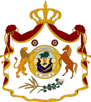
The Euphrates river was even shown on the coat of arms of Iraq from 1932-1959.
On April 15, 2014, Turkey began to reduce the flow of the Euphrates into Syria and Iraq. By May 16, 2014, the flow was completely stopped at the Turkish–Syrian border. This went against the 1987 agreement.
During the Syrian Civil War and the Iraqi Civil War, much of the Euphrates was controlled by the Islamic State from 2014 to 2017. The group eventually lost control of the area.
The Euphrates and the Economy
The Euphrates has always been very important to the people living along its banks. Today, even more people rely on the river. This is because of large hydropower stations, irrigation systems, and pipelines that carry water far away. The river provides electricity and drinking water.
Syria's Lake Assad is the main source of drinking water for the city of Aleppo. This city is about 75 kilometres (47 mi) west of the river valley. The lake also supports a small fishing industry run by the government. In Iraq, the Haditha Dam provides electricity to Baghdad through a restored power line.
See also
 In Spanish: Éufrates para niños
 | Toni Morrison |
 | Barack Obama |
 | Martin Luther King Jr. |
 | Ralph Bunche |


