
Shuruppak facts for kids
| [[File::None at this time|frameless]] | |
| Lua error in Module:Location_map at line 420: attempt to index field 'wikibase' (a nil value). | |
| Alternative name | Tell Fara |
|---|---|
| Location | Al-Qādisiyyah Governorate, Iraq |
| Region | Sumer |
| Type | archaeological site, human settlement |
| Area | 120 hectare |
| Height | 9 metre |
| History | |
| Periods | Jemdet Nasr period, Early Dynastic period, Akkad period, Ur III period |
| Site notes | |
| Excavation dates | 1900, 1902-1903, 1931, 1973, 2016-2018 |
| Archaeologists | Robert Koldewey, Friedrich Delitzsch, Erich Schmidt, Harriet P. Martin |
Shuruppak was an ancient city in the land of Sumer, which is now modern-day Iraq. Its ruins are known today as Tell Fara. The city was located on the banks of the Euphrates river, about 55 kilometers (35 miles) south of the famous city of Nippur.
The people of Shuruppak worshiped Ninlil, the goddess of grain and air. The city is very famous in Mesopotamian legends because it was the home of the hero who survived a great flood, similar to the story of Noah's Ark. This hero is sometimes called Ziusudra or Utnapishtim.
Contents
A Journey Through Time in Shuruppak
Shuruppak was a busy city for thousands of years. Archaeologists have divided its history into different periods based on what they found buried in the ground.
The First Settlers
The oldest parts of Shuruppak that have been dug up date back to the Jemdet Nasr period, around 3000 BC. This was a time when people were just starting to build big cities. Archaeologists found tools and other objects made of arsenical copper, a special type of metal used back then.
A Growing City
.png)
During the Early Dynastic period, Shuruppak grew much larger and more important. By about 2600 BC, the city covered around 100 hectares, which is about the size of 140 soccer fields.
Ancient clay tablets found at the site show that Shuruppak had a strong army and traded with many other cities. Some historians think Shuruppak was part of a "hexapolis," which was a group of six powerful cities that worked together. These cities included Lagash, Nippur, and Uruk.
Life Under Empires
Later, Shuruppak became part of the powerful Akkadian Empire. During this time, the city was ruled by a governor. Like many cities in the area, it became less important during this period.
After the Akkadian Empire fell, Shuruppag was ruled by the Third Dynasty of Ur. Governors were sent from the capital city of Ur to manage Shuruppak. However, around 2000 BC, a major drought hit the region, and it is believed that the city was abandoned soon after. People left, and the city slowly turned into ruins.
The Great Flood Legend

One of the most exciting things about Shuruppak is its connection to a famous flood story. In Mesopotamian myths, like the Epic of Gilgamesh, Shuruppak is the home of a wise king named Utnapishtim. The gods tell Utnapishtim that they are going to send a giant flood to destroy the world. He saves himself, his family, and animals by building a huge boat.
When archaeologists were digging at Shuruppak in the 1930s, they found a thick layer of mud and clay that had been deposited by a flood. This layer was right on top of the ruins from the Jemdet Nasr period. This discovery made many experts think that the ancient myths might have been based on a real, massive flood that happened thousands of years ago. Similar flood layers were also found at other ancient cities like Ur and Kish.
Digging Up the Past: What Archaeologists Found
The ruins of Shuruppak, called Tell Fara, are a large mound that rises about 9 meters (30 feet) above the surrounding plain. Archaeologists have been exploring the site for over a hundred years.
Early Explorations
The first major dig at Shuruppak was done by a German team between 1902 and 1903. They found hundreds of cuneiform tablets. Cuneiform is one of the world's oldest forms of writing, made by pressing a wedge-shaped tool into wet clay.
These tablets were like ancient records. They included government documents, legal contracts, and even lists of words for scribes to study. Over 100 tablets were lists of food and supplies given to workers, which tells us how the city's economy worked.
In 1931, a team from the University of Pennsylvania came to dig. They found more tablets and were able to confirm that the site was indeed the ancient city of Shuruppak. They also found evidence of the great flood that separated the earliest city from the later one.
Modern Discoveries

More recently, from 2016 to 2018, another team of archaeologists used modern technology to study the site. They used drones to create a 3D map of the ruins and special tools to see what was buried underground without digging.
They discovered a city wall that previous teams had missed. They also found what they believe was a harbor, where boats would have docked to trade goods. Sadly, they also found that many parts of the site had been damaged by looters who dug holes looking for ancient artifacts to sell.
Among the many cool things found at Shuruppak over the years are a well made of special bricks, clay seals used to lock doors, and even a cute rattle shaped like a pig.
Images for kids
-
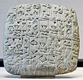
A bill of sale written on a clay tablet, now in the Louvre Museum.

See also
