
Edgware facts for kids
Quick facts for kids Edgware |
|
|---|---|
Aerial view of Edgware from Station Road; facing North towards Broadfields and Elstree. |
|

Edgware
|
|
| Population | 58,619 (2011 Census Estimate) |
| OS grid reference | TQ195925 |
| • Charing Cross | 10 mi (16 km) SE |
| London borough | |
| Ceremonial county | Greater London |
| Region | |
| Country | England |
| Sovereign state | United Kingdom |
| Post town | EDGWARE |
| Postcode district | HA8 |
| Post town | LONDON |
| Postcode district | NW7 |
| Dialling code | 020 |
| Police | Metropolitan |
| Fire | London |
| Ambulance | London |
| EU Parliament | London |
| UK Parliament |
|
| London Assembly |
|
Edgware is a town in northern Greater London, England. It is mostly in the London Borough of Barnet. Some parts are also in the London Borough of Harrow and the London Borough of Brent. Edgware is about 9.5 miles (15.3 km) northwest of central London. It has its own busy town centre.
Edgware feels like a typical suburban area, which means it has many homes and shops. It used to be an old parish in the county of Middlesex. The famous Edgware Road runs from central London right up to the town. Edgware also has some nice woodlands on a high ridge.
This town is mainly a place for shopping and living. It is seen as one of London's 35 main centres. It is also the end point for one branch of the Northern line on the London Underground. Edgware has a bus garage, a shopping centre called the Broadwalk Centre, a library, and a community hospital. Two small streams, Edgware Brook and Deans Brook, flow through the area.
In 2011, about 58,619 people lived in Edgware.
Contents
History of Edgware
Edgware has a long history, going back to ancient times. Its name comes from an old Saxon word. It means "Ecgi's weir," which was a pond where a Saxon person named Ecgi and his people caught fish.
The Romans also lived near Edgware. They made pottery at a place called Brockley Hill. Later, a large estate called Canons Park was built here. It was home to a grand palace called Cannons, built by James Brydges, the first Duke of Chandos.
For many years, Edgware was a small parish. Its population grew slowly until the 20th century. After 1924, many new homes were built, and the population grew very quickly. For example, in 1921, about 1,500 people lived here. By 1931, it was over 5,000, and by 1961, it was more than 20,000! In 2008, Edgware was chosen as an important area for new development in London.
Geography of Edgware
Edgware is known as a "post town." This means it's a main area for mail delivery. It is mostly in the HA postcode area, but some parts are also in the NW postcode area.
 |
Stanmore | Elstree | Borehamwood | |
| Queensbury | Mill Hill | |||
| Kingsbury | Colindale | Hendon |
People and Religions

Edgware has a diverse population with many different backgrounds and religions. As the town grew, so did its different communities.
According to the 2001 Census, many people in Edgware are Jewish (36%). There are also many Christians (28%), Hindus (9%), and Muslims (5%). The Jewish community in Edgware has even created an Eruv, which is a special boundary that allows them to carry things on the Sabbath.
The 2011 census showed that in the Edgware ward, most people were White (60%), with many also being Indian (13%) and Black African (7%). The most common foreign language spoken was Gujarati.
Economy and Businesses


Edgware has been home to some interesting businesses. Argonaut Games, a company that designed computer games, used to have its main office here. They even worked on the famous game Worms.
Green Shield Stamps also had its headquarters in Edgware. This company used to give out stamps that people could collect and exchange for gifts. The building where they were based, Premier House, is still there today.
There's also a local legend about the famous highwayman Dick Turpin. People say he used to stop travellers at a crossroads in Edgware. There was even an antique shop named "Dick Turpin's Halt" in the 1960s, and the old timbered shop building is still standing.
Media
If you want to know what's happening in Edgware, you can read the local news. It's provided by the Times series, which is available every week in print or online.
Education in Edgware
Edgware has many schools for children and teenagers. Here are some of them:
- London Academy
- Beit Shvidler Primary School
- Holland House School
- Broadfields Primary School
- Deansbrook Primary School
- Krishna Avanti Primary School, Harrow
- North London Collegiate School
- Rosh Pinah Primary School
- Edgware Junior School
- Canons High School
Transport in Edgware

Edgware is well connected by public transport, especially the London Underground and buses.
Tube Stations
There are four Tube stations that serve the Edgware area:
- Edgware (Northern line)
- Burnt Oak (Northern line)
- Canons Park (Jubilee line)
- Queensbury (Jubilee line)
.jpg)
Buses

Many London Buses routes serve Edgware during the day and at night. There are also special bus services for schools.
Sports in Edgware
Edgware has local sports clubs. Edgware Cricket Club plays cricket during the summer at Canons Park. There is also a football club called Edgware Town F.C., though they currently play their games in Kingsbury.
Famous People from Edgware
Many well-known people have lived in or are connected to Edgware. Here are a few:
- Nicolas Anelka — a famous footballer who played for Arsenal.
- John Bercow — a former Speaker of the House of Commons.
- Max Bygraves — a popular singer, comedian, and actor.
- Antony Costa — a singer from the boy band Blue.
- Sope Dirisu - an actor.
- Vanessa Feltz — a TV and radio presenter.
- George Frideric Handel — a very famous composer.
- George Michael — a globally known pop singer.
- Pat Sharp — a disc jockey and television presenter.
- Frank Williams — an actor, famous for playing the vicar in Dad's Army.
Images for kids
-
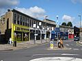
Kings Parade, Edgwarebury Lane.
-
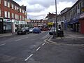
Edgwarebury Lane
-
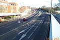
A41 Edgware Way, located north from Edgware town centre. View from Edgwarebury Lane footbridge.
-
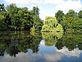
Basin Lake, located in Canons Drive to the west of Edgware. It is located in the borough of Harrow
-
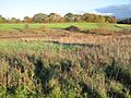
Grassland in Edgwarebury Park, taken from the A41 Edgware Way/Watford-by-Pass. This is the far north, rural area of Edgware.
-
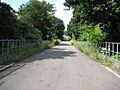
Former track of the Great Northern Railway line, which closed in 1964. View from Dean's Lane in the east of Edgware
-
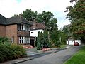
Rose Garden Close in western Edgware, near Canons Drive. This road consists of large suburban houses, near Lake Grove
-
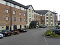
Premier Inn hotel, Edgware


See also
 In Spanish: Edgware para niños
