
Brockley Hill facts for kids
Quick facts for kids Brockley Hill |
|
|---|---|
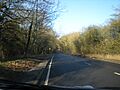
 A5 road northwards over Brockley Hill |
|

Brockley Hill
|
|
| OS grid reference | TQ174940 |
| London borough | |
| Ceremonial county | Greater London |
| Region | |
| Country | England |
| Sovereign state | United Kingdom |
| Post town | HARROW |
| Postcode district | HA7 |
| Dialling code | 020 |
| EU Parliament | London |
| London Assembly |
|
Brockley Hill is a high area of land in North London, England, near Stanmore. This hill reaches about 136 meters (446 feet) above sea level. A major road, the A5, crosses over it. This road follows the path of an ancient Roman road called Watling Street. Brockley Hill is also linked to an old Roman site known as Sulloniacis. The Royal National Orthopaedic Hospital is located here too.
Contents
What's in a Name?
The name "Brockley Hill" as we know it today started in the 1500s. Before that, it was called Brokhole(s). This old name meant 'badger-holes'. It comes from an old English and Celtic word, Brock, which means badger. The soil on top of the hill is sandy. This makes it a good place for animals like badgers to dig their homes, unlike the heavier clay soil nearby.
Exploring Brockley Hill
How the Hill Was Formed
Brockley Hill is part of a longer hill that includes Stanmore. The very top of the hill has a layer of "Stanmore Gravel." This gravel was left behind by an ancient river system, even older than the River Thames.
Below the gravel are layers of sand, silt, and clay. These layers are about 15 meters (49 feet) thick and are called the Claygate Beds. Underneath all of this is about 70 meters (230 feet) of London Clay. This type of ground structure is common for hills around the Thames Valley.
Roads and History
The A5 trunk road goes right over the top of Brockley Hill. This road follows the exact path of a highway built by the Romans in the 1st century AD. The Romans called this highway Watling Street.
When you approach the hill from the south, the road climbs about 70 meters (230 feet) over 1,400 meters (0.87 miles). This area might have been Sulloniacis, a stop for the Roman Imperial mail service, called the Cursus publicus.
Some people thought a smaller Roman road branched off from Brockley Hill towards Watford. However, studies of old parish boundaries show no proof of this route.
As the road goes down the north side, it drops about 30 meters (98 feet) in 600 meters (0.37 miles). The Roman roads leading to Brockley Hill are usually straight. But the path across the very top of the hill has a double bend. This was done to make the climb less steep for travelers.
The M1 motorway and the A41 Watford Way also pass through the valley between Brockley Hill and Elstree Hill to the north.
Local Area
Brockley Hill used to be in Stanmore, which was part of Middlesex County. This was until 1965 when Middlesex was abolished.
Today, the road named Brockley Hill, and the properties on both sides, are in Stanmore. This area is part of the London Borough of Harrow. The fields to the east of the road are in Edgware, which is in the London Borough of Barnet.
Places Nearby
A Look Back in Time
Brockley Hill sits on the ancient Watling Street. The Romans improved this road early in their time in Britain. The section of the road from Marble Arch runs straight until it reaches the top of Brockley Hill. Then, it curves twice to meet the next straight part. Roman engineers often used high points like Brockley Hill to help them plan straight roads.
The sandy clay found at the top of the hill was used to make pottery during the Roman period. In the late 1st century, it was one of the most important pottery-making sites in southern Britain. The Romans knew this area as Sulloniacis.
The historian Daniel Lysons wrote about Roman finds in the area in his 1795 book. He mentioned an old saying: "No heart can think, nor tongue can tell, what lies between Brockley-hill and Pennywell". He thought this proverb meant there was Roman treasure to be found. Pennywell is in Elstree, about 1,500 meters (0.93 miles) north of Brockley Hill. Today, between Brockley Hill and Pennywell, you'll find busy roads like the M1 motorway and the A41 Watford Bypass.
Close to Brockley Hill is the eastern end of an old earthwork called Grim's Ditch or Grimsdyke. This was built during the Dark Ages.
In the 1700s, bricks were made on the hill.
The first hospital on the site of the Royal National Orthopaedic Hospital opened in 1882. The RNOH bought the land and buildings in 1920.
In the 1930s, there were plans to extend the London Underground's Northern line. It would have run from Edgware to Bushey Heath. A station called Brockley Hill was planned for the southern foot of the hill. However, this work stopped when World War II began. You can still see the lower parts of a brick bridge (viaduct) that would have carried the train line through the station. This is in a field known as 'Arches Field'. After the war, the planned housing around Brockley Hill was not allowed because of the new Metropolitan Greenbelt rules. So, the train line was no longer needed.
Images for kids
-
A5 road northwards over Brockley Hill
