
Bedfordshire facts for kids
Quick facts for kids
Bedfordshire
|
|||||||||||||||||||||||||||||
|---|---|---|---|---|---|---|---|---|---|---|---|---|---|---|---|---|---|---|---|---|---|---|---|---|---|---|---|---|---|
|
|
|||||||||||||||||||||||||||||

Location of Bedfordshire in England
|
|||||||||||||||||||||||||||||
| Sovereign state | United Kingdom | ||||||||||||||||||||||||||||
| Constituent country | England | ||||||||||||||||||||||||||||
| Region | East | ||||||||||||||||||||||||||||
| Established | Ancient | ||||||||||||||||||||||||||||
| Time zone | UTC±00:00 (Greenwich Mean Time) | ||||||||||||||||||||||||||||
| • Summer (DST) | UTC+01:00 (British Summer Time) | ||||||||||||||||||||||||||||
| Members of Parliament | List of MPs | ||||||||||||||||||||||||||||
| Police | Bedfordshire Police | ||||||||||||||||||||||||||||
| Largest town | Luton | ||||||||||||||||||||||||||||
|
|||||||||||||||||||||||||||||

.jpg)


Bedfordshire is a county in the East of England. It is often called Beds for short. The county shares borders with Northamptonshire to the north, Cambridgeshire to the north-east, Hertfordshire to the south and south-east, and Buckinghamshire to the west.
The largest town in Bedfordshire is Luton, with over 225,000 people. The main county town is Bedford. Other towns include Leighton Buzzard, Dunstable, and Biggleswade. Much of Bedfordshire is made up of countryside. For local government, Bedfordshire is split into three main areas: Bedford, Central Bedfordshire, and Luton.
The highest point in the county is Dunstable Downs, which is about 243 metres (797 feet) high.
Contents
History of Bedfordshire

The name "Bedfordshire" was first recorded in 1011 as "Bedanfordscir." This means "the shire or county of Bedford." The name Bedford itself means "Beda's ford," referring to a place where people could cross a river.
Over time, the borders of Bedfordshire have changed a few times. For example, in 1897, some areas like Kensworth and part of Caddington became part of Bedfordshire instead of Hertfordshire.
Geography and Landscape

The southern part of Bedfordshire is home to the Chiltern Hills, which are made of chalk. The rest of the county is mostly part of the area drained by the River Great Ouse and its smaller rivers.
Most of the rocks in Bedfordshire are clays and sandstones. These were formed during the Jurassic and Cretaceous periods, which were millions of years ago. Some areas also have limestone. The local clay has been used to make bricks for a long time.
Long ago, glaciers moved across the land. As they melted, they left behind hard flint rocks, which are now found as gravel. These gravel pits have since become lakes, like those at Priory Country Park. The Bedfordshire Greensand Ridge is a hilly area that stretches across the county from Leighton Buzzard to Gamlingay.
Bedfordshire's Climate
Bedfordshire is in the east of England, which means it has a fairly dry climate compared to other parts of the UK. It gets regular but usually light rainfall. On average, Bedford receives about 608.6 mm (23.96 inches) of rain each year. October is usually the wettest month, and March is the driest.
Temperatures are usually mild. However, Bedfordshire has seen some of the biggest temperature differences in the UK. The average temperatures in Bedford range from about 1.5°C (34.7°F) at night in February to 22.4°C (72.3°F) during the day in July. The highest temperature ever recorded in Bedfordshire was 39.7°C (103.5°F) in 2022, and the lowest was -20.6°C (-5.1°F) in 1947.
Economy and Businesses
Bedfordshire is home to many well-known UK and international companies. Some of these companies have their main offices or large bases here.
For example:
- Autoglass and Charles Wells Pubs are based in Bedford.
- Kier Group and Kingspan Timber Solutions are in Sandy.
- Jordans Cereals is located in Biggleswade.
- EasyJet, TUI Airways, and Vauxhall Motors are all based in Luton.
- Whitbread is in Houghton Regis.
- Costa Coffee is now based in Dunstable.
- UltraVision is in Leighton Buzzard.
Traditional Foods
Bedfordshire has a couple of unique local dishes:
- The "Bedfordshire clanger" is a pastry with a suet crust. It's special because it has meat in one end and fruit jam in the other! Farm workers traditionally ate it because it was a full meal that was easy to carry and left no waste.
- "Chocolate Toothpaste" is a chocolate tart. It has a chocolate filling that is said to feel a bit gritty, like toothpaste. It's often topped with whipped cream.
Places to Visit
.jpg)
Bedfordshire has many interesting places to visit, from historic sites to beautiful parks and wildlife areas.
| Key | |
| Owned by the National Trust | |
| Owned by English Heritage | |
| Owned by the Forestry Commission | |
| A Country Park | |
| An Accessible open space | |
| Museum (free) | |
| Museum (charges entry fee) | |
| Heritage railway | |
| Historic House | |
 Bedford Castle
- Bedford Corn Exchange
 Bushmead Priory
 Cecil Higgins Art Gallery & Bedford Museum
 Bedford Park
- Cardington (R101 hangar)
 Chicksands Priory
- Chiltern Hills
- De Grey Mausoleum
 Dunstable Downs
 Elstow Moot Hall
 Harrold-Odell Country Park
- Houghton House
 Leighton Buzzard Light Railway
- Luton Hoo
- Luton Museum & Art Gallery
- Marston Vale Community Forest
- Mossman Collection
- Priory Country Park
- RAF Henlow
- RSPB The Lodge, Sandy
- Someries Castle
- The Shuttleworth Collection
 St Paul's Church
- Stockwood Craft Museum
- Swiss Garden, Old Warden
- Wardown Park
- Waulud's Bank
 Whipsnade Wildlife Park
- Whipsnade Tree Cathedral
- Willington Dovecote & Stables
- Woburn Abbey
- Woburn Safari Park
- Woodside Farm and Wildfowl Park
- Wrest Park Gardens
Transport in Bedfordshire
Bedfordshire is an important area for transport, as many major routes connecting London to the Midlands and Northern England pass through it.
Roads
Two of England's main roads, the A1 (which goes from London to Edinburgh) and the A5 (an old Roman road called Watling Street), run through or near Bedfordshire.
The M1 motorway, which connects London to Leeds, also passes through the county. It has several junctions that serve towns like Luton, Bedford, and Dunstable. There is also a motorway service station called Toddington Services.
Railways
Three major railway lines cross Bedfordshire:
- The West Coast Main Line has a station at Leighton Buzzard.
- The East Coast Main Line has stations at Arlesey, Biggleswade, and Sandy.
- The Midland Main Line serves Luton, Luton Airport (via the Luton DART link), and Bedford.
There are also local train services between Bedford and Bletchley on the Marston Vale Line.
Waterways
The River Great Ouse connects Bedfordshire to a network of waterways in the Fenland area. There are also plans to build a new canal that would link the River Great Ouse at Bedford to the Grand Union Canal at Milton Keynes.
Air Travel

Luton Airport is one of the busiest airports in the UK. It offers flights to many places in the UK, Europe, the Middle East, and North Africa. Many of these flights are operated by low-cost airlines.
Local Media
Local news for Bedfordshire is provided by BBC East and ITV Anglia, which broadcast from Cambridge. In the southern part of the county, like Luton, people can also receive news from BBC London and ITV London.
There are several local radio stations, including:
- BBC Three Counties Radio (broadcast from Dunstable)
- Heart East
- Greatest Hits Radio Bucks, Beds and Herts
- BigglesFM (for Biggleswade, Potton, and Sandy)
- In2beats (Bedford)
- Radio LaB (Luton)
Education in Bedfordshire
The way schools are organized in Bedfordshire has changed over the years. Historically, most of the county used a "three-tier" system with lower, middle, and upper schools. However, Luton always used a "two-tier" system (infant/junior and high schools).
After 2009, when the local government changed, the responsibility for education was split between Bedford Borough Council and Central Bedfordshire Council.
Bedford Borough Schools
Bedford Borough Council decided to switch to a two-tier school system. This change has been happening gradually, and by 2020, most of Bedford Borough had moved to this system, with students typically moving from primary to secondary school.
Many secondary schools in the area offer sixth form courses (like A Levels) for older students. There are also colleges like Bedford College and The Bedford Sixth Form that offer further education courses.
Bedford also has several independent schools, some of which are linked to the Harpur Trust. These include Bedford School and Bedford Girls' School.
Central Bedfordshire Schools

In Central Bedfordshire, some areas like Dunstable and Sandy have also moved to the two-tier school system. However, other parts of Central Bedfordshire still use the three-tier model.
For further education, students can attend sixth forms in schools or go to colleges like Central Bedfordshire College and Shuttleworth College.
Luton Schools
Luton still uses a three-tier education system, but it's set up differently, with infant, junior, and high schools. Most high schools in Luton do not have their own sixth forms. Instead, students go to Luton Sixth Form College for their post-16 education. Barnfield College also offers a range of further education courses.
Universities in Bedfordshire
Bedfordshire is home to two universities:
- The University of Bedfordshire
- Cranfield University
These universities attract students from all over the UK and other countries.
Famous Landmarks
Cardington Airship Sheds
The huge Cardington airship sheds are located south of Bedford. They were originally built during World War I to construct large airships. Since then, they have been used for many different things, including as film sets for movies like 'Charlie and the Chocolate Factory' and 'Batman Begins'. They have also been used as rehearsal spaces for bands like Take That. One of the sheds is now used by Hybrid Air Vehicles, a company that designs and builds modern airships.
St Paul's Church Bedford
St Paul's Church, Bedford is a very important church in Bedford and for the whole county. It's a large, old church with a famous spire that stands out in the town. Many visitors come to see it each year. During World War II, St Paul's Church was especially important because it was the church used by the BBC.
Millbrook Proving Ground
The Millbrook Proving Ground is a special place near the M1 motorway. It has about 70 kilometres (43 miles) of different test tracks where vehicles are tested.
Sports and Fun Activities
Bedfordshire is home to the Premier League football team Luton Town F.C.. It also has rugby teams like Ampthill RUFC and Bedford Blues.
For people who enjoy walking, there's the Greensand Ridge Walk, which is about 64 kilometres (40 miles) long and goes across the county. Cyclists can use the Greensand Cycle Way, which follows quiet country roads.
Images for kids
-
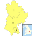
Map showing the three unitary authority areas of Bedfordshire
See also
 In Spanish: Bedfordshire para niños
