Mosborough (ward) facts for kids
Quick facts for kids Mosborough |
|
|---|---|
 Shown within Sheffield |
|
| Population | 17,097 (ward. 2011) |
| Metropolitan borough | |
| Metropolitan county | |
| Region | |
| Country | England |
| Sovereign state | United Kingdom |
| EU Parliament | Yorkshire and the Humber |
| UK Parliament |
|
| Councillors | David Barker (Labour Party) Gail Smith(Liberal Democrats) Tony Downing (Labour Party) |
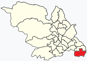
Mosborough is a special area, or "ward," in the City of Sheffield, England. It's located in the eastern part of the city, right on the edge of the North East Derbyshire District. In 2011, about 17,097 people lived here. Mosborough is also part of the Sheffield South East area, which elects a Member of Parliament.
Contents
Exploring Mosborough Ward
Mosborough ward is made up of several smaller areas. These include Halfway, Holbrook, Mosborough itself, Waterthorpe, Westfield, and Plumbley. Each area has its own unique history and features.
Halfway: A Community with History
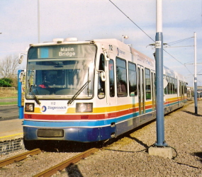
Halfway (grid reference SK432809) is in the very southeast of Sheffield. It's the final stop for one of the Sheffield Supertram lines. Halfway used to be part of Derbyshire. However, it became part of Sheffield in 1967 due to boundary changes.
This area was once home to a bus garage. It was used by different bus companies over the years. The garage closed in 2007 to save money. More recently, a company called TM Travel took it over.
You'll often see public transport in Sheffield heading to Halfway. The Blue Route Sheffield Supertram ends here. There's also a large Park and Ride area. The main bus service to the city centre is the 120 route. Both Stagecoach Sheffield and First South Yorkshire operate it.
Halfway Housing Estate: A Unique Design
The Halfway housing estate was built in 1975. It was designed around a small shopping area called Streetfields. The houses were built on good farmland. Even today, you can find farms and orchards nearby.
Sheffield City Council uses a special system here. They burn household rubbish to create energy. This energy is then turned into hot water. This hot water is pumped to Halfway homes for heating and hot water. These homes are well-insulated and save a lot of energy.
The estate was planned so that no house directly faces another. Properties curve around paths and a network of routes. These connect to Halfway Drive, the main road. This road links the area to Derbyshire and nearby estates like Westfield.
Even though it was well-planned, the estate has faced some challenges. The Sheffield City Council website has mentioned working to make the community safer.
Holbrook: A Former Mining Village
Holbrook was once a mining village. Its name was changed to Halfway to avoid confusion with another Holbrook near Derby. However, the name Holbrook is still used. You can find it in road names and business areas.
grid reference SK442818
Holbrook Commerce Park: Business Hub
Several companies are located in Holbrook Commerce Park. These include Holbrook Telecom Limited and High Availability Hosting Limited.
Holbrook Industrial Estate: Industry and Innovation
Evolution Power Tools Ltd. is one company located in the Holbrook Industrial Estate.
Mosborough: A Historic Sheffield Suburb
Mosborough (grid reference SK426813) was also part of Derbyshire before 1967. Now, it's considered a suburb of Sheffield. It was known for making sickles, which are tools for cutting crops. It was also a coal mining area.
Notable Buildings in Mosborough
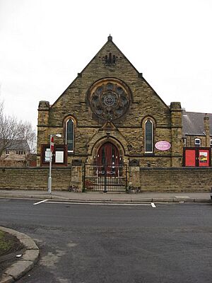
Important buildings include the 15th-century Mosborough Hall. This building might even have some very old Anglo-Saxon parts. Another key building is St Mark's Church. In 2011, Mosborough Town had a population of 4,063 people.
The suburb has many nice houses and local independent shops. There are also hotel facilities for conferences.
Mosborough's Pubs and Community Spirit
In the 1930s and 1940s, Mosborough had many more pubs than it does today. Some of the old pubs included The Fitzwilliam, The British Oak, and The Queens Hotel.
The local working men's club is the CIU affiliated Miners Welfare.
Every August Bank Holiday, locals take part in a fun event. They do a "pub crawl" called the Mosborough 10. People often dress up in costumes for charity. People have even traveled from places like Blackpool to join in.
Waterthorpe: Modern Housing and Shopping
Waterthorpe is a housing estate near Beighton. It was named after Waterthorpe Farm.
grid reference SK430827
The Waterthorpe and Westfield housing estates were built starting in the mid-1970s. They grew over time, connecting with older areas like Beighton and newer ones like Halfway. These estates have many properties that were originally owned by the local council.
Crystal Peaks Shopping Centre
The Crystal Peaks shopping centre opened in 1988. It was built to serve the south side of Sheffield. Its first design included markets and well-known shops. It even had a UCI Cinema. Crystal Peaks originally had a ski theme. There was a cable car and skiing mannequins hanging from the glass roof.
The centre has always had a petrol station. Crystal Peaks was very popular at first. However, its popularity decreased after the Meadowhall Centre opened in 1990.
In 1998, Crystal Peaks added an extension called "Crystal Peaks 2." This covered a new area from the market downwards. A playground was moved to a different part of the centre. Later, between 2005 and 2008, more changes happened. The Sainsbury's supermarket moved into a much larger, new building. This new building included a car park on the roof.
For Waterthorpe and Westfield estates, there aren't many leisure facilities. The council focused on building homes. Other areas of Sheffield have more parkland.
Crystal Peaks Bus Station: A Transport Hub
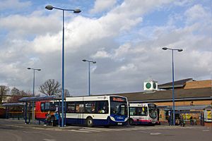
The Crystal Peaks bus station serves the Crystal Peaks shopping complex in Waterthorpe. It is located at Peak Square, very close to the Sheffield Supertram stop.
The bus station has eight stands. Major bus companies like First South Yorkshire and Stagecoach Sheffield operate here. Buses from this station go towards Sheffield, Rotherham, Eckington, and Worksop.
Westfield: A Developing Community
Westfield is one of the "Townships" in Mosborough. These are smaller, self-contained communities that are still growing. It's on the edge of Sheffield, looking out towards Derbyshire. To the north, it has many houses. To the south, there's open countryside. It has a small but well-equipped shopping centre.
The housing in Westfield is a mix of private homes and public sector housing. The public housing was originally for more vulnerable or elderly residents. Around 2006, the local primary school, "Shortbrook School," the community centre, and the doctor's surgery were damaged by fire. The surgery moved temporarily. The central surgery has since reopened. Shortbrook Primary also reopened with new staff. Westfield Secondary School moved from Mosborough village and opened in Westfield in 2007. There are still some issues with community facilities.
Recently, a former pub called "Golden Keys" was turned into a community centre or youth club. The council has agreed to invest about £50,000 to help Westfield recover. The local Co-op store and the Primary Care Trust are also investing in the area.
Plumbley: Rural Charm
Plumbley is a small hamlet in the west of the ward. It is mostly rural, with a few homes and farms. The area around it is part of the South and West Yorkshire Green Belt, which protects it from too much development.
 | James Van Der Zee |
 | Alma Thomas |
 | Ellis Wilson |
 | Margaret Taylor-Burroughs |


