
Shelton Lock facts for kids
Quick facts for kids Shelton Lock |
|
|---|---|
 Shelton Lock bridge |
|

Shelton Lock
|
|
| OS grid reference | SK375313 |
| Unitary authority | |
| Ceremonial county | |
| Region | |
| Country | England |
| Sovereign state | United Kingdom |
| Post town | DERBY |
| Postcode district | DE24 |
| Dialling code | 01332 |
| Police | Derbyshire |
| Fire | Derbyshire |
| Ambulance | East Midlands |
| EU Parliament | East Midlands |
| UK Parliament |
|
Shelton Lock is a small area, or suburb, located in the southern part of Derby, England. It sits between the areas of Chellaston and Allenton.
Contents
The Derby Canal's History
The name Shelton Lock comes from a special gate, called a lock, on the Derby Canal. This canal used to run right through the area. Today, you can still see hints of the canal. There's a road bridge, some old lock stones, and a cycle path. This path was built over where the canal used to be.
The Derby Canal stopped being used in the 1960s. However, there are plans to dig it out again and bring it back to life. A place called Fullen's Lock is just a short walk along the cycle path from Shelton Lock bridge. There's even a children's playground nearby that still has the name "Fullen's Lock."
Schools and Main Roads
Merrill College is the main secondary school for the area. The old school building on Jubilee Road was taken down. A new Merrill College was built in Allenton. Shelton Lock also has schools for younger children. These include an infant school and a junior school.
Chellaston Road is the most important road in Shelton Lock. Many houses built between World War I and World War II can be found here. These houses are privately owned.
Local Estates and Landmarks
The George V Jubilee Estate was built in 1935. This was done to celebrate King George V's 25th year as king. This estate is located to the west of Jubilee Road. St Edmund’s Church is on Sinfin Avenue. It was designed by a Derby architect named Arthur Eaton and opened in 1939.
The Sinfin Avenue estate was built in the 1970s. It has both council houses and private homes. Behind this estate, you can find fields and woods. These areas are part of Sinfin Moor. There's also an old railway line that goes towards Chellaston. A large part of these fields and woods has now been built on. This new area is called the Bonnie Prince housing estate.
Transport Connections
Years ago, a new road was planned to go through Shelton Lock. This road was meant to connect to the Rolls-Royce factories. However, this plan was never finished. Instead, the route was used for the A50 road. Shelton Lock is connected to the A50 by the A514 road.
Gallery
-
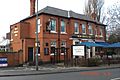
The New Bridge Inn public house
-
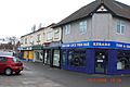
The shops on Chellaston Road
-
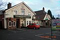
The Golden Pheasant public house
-
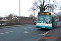
Number 60 bus traveling from Derby to Chellaston, on Shelton Lock bridge


