Huddersfield Broad Canal facts for kids
Quick facts for kids Huddersfield Broad Canal |
|
|---|---|

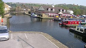
Aspley Basin, near the junction between the Broad and Narrow canals
|
|
| Specifications | |
| Maximum boat length | 57 ft 6 in (17.53 m) |
| Maximum boat beam | 14 ft 2 in (4.32 m) |
| Locks | 9 |
| Status | operational |
| Navigation authority | Canal & River Trust |
| History | |
| Date of act | 1774 |
| Date completed | 1776 |
| Geography | |
| Start point | Cooper Bridge Junction |
| End point | Huddersfield |
| Connects to | Calder and Hebble Navigation, Huddersfield Narrow Canal |
The Huddersfield Broad Canal, also called Sir John Ramsden's Canal, is a canal in West Yorkshire, England. It is 3.75 miles (6 km) long and has 9 wide locks. The canal follows the River Colne valley. It connects the Calder and Hebble Navigation at Cooper Bridge with the Huddersfield Narrow Canal near Aspley Basin in Huddersfield.
Building the canal was approved in 1774, and it opened just two years later. In 1811, it became part of a route across the Pennines when the Huddersfield Narrow Canal joined it. However, boats from the narrow canal were too long for Ramsden's Canal's shorter locks. Goods had to be moved from one boat to another at Aspley Basin. Even though shorter boats were built, the Rochdale Canal became a more popular route across the Pennines. This was because the Rochdale Canal had wide locks all the way.
In 1845, a railway company bought the canal. It continued to be busy into the 1900s. The railway company stopped owning it in 1945. Then, the Calder and Hebble Navigation bought it. At this time, the narrow canal across the Pennines was closed. The broad canal carried goods, especially coal for power stations, until 1953.
In 1962, British Waterways took over the canal. By 1968, it was named a "cruiseway," meaning it was mainly for leisure boats. More people have used the canal since the Huddersfield Narrow Canal reopened in 2001. This is because it is no longer a dead end. Many of its old structures are now listed buildings. This means they are important historic places.
Contents
History of the Canal
The idea for the canal was around for a while before it was approved. In 1758, the Calder and Hebble Navigation got a special law passed for its canal. This law said that no one could stop a future canal from the River Colne to Huddersfield. Robert Whitworth surveyed a route for the canal in 1766.
In 1773, Luke Holt and Joseph Atkinson surveyed the route again. They worked for the Ramsden family, who owned all of Huddersfield. The family wanted to build the canal and owned about a third of the land needed. Holt had also worked on the Calder and Hebble canal.
Getting Permission to Build
Atkinson spoke to the government committee about the canal. He said that Huddersfield was the only market for woollen cloths in West Yorkshire. The canal was expected to cost £8,000 and take one year to build. The law that allowed the canal also said that fees had to be lowered if the canal made too much money. Special people called commissioners were chosen to check the canal's accounts.
To make sure local mills had enough water, the top 1.5 miles (2.4 km) of the canal were made deeper. This created a water storage area.
Building the Canal
A special law, called an Act of Parliament, was passed on March 9, 1774. This law allowed Sir John Ramsden to build a canal. It would go from the River Calder to King's Mill, near Huddersfield.
Even though the law allowed a connection to the River Colne in Huddersfield, the canal ended at a basin in Aspley. Here, Ramsden built places for boats to load and unload goods. From Aspley Basin, the canal dropped 57.3 feet (17.5 m) over 3.75 miles (6 km). It joined the Calder and Hebble Navigation at Cooper Bridge.
The canal opened in 1776. It cost £11,975, which included some early repair costs. Water for the canal came from the River Colne. After 1811, the Huddersfield Narrow Canal supplied the water.
How the Canal Was Used
The canal did well. By 1788, boats carried goods between Huddersfield and Wakefield three times a week. In the 1790s, goods were moved across the Pennines by road. One company ran daily boat trips from Huddersfield to Wakefield. From Wakefield, boats could go to Hull.
The broad Rochdale Canal was being built towards Sowerby Bridge. Meanwhile, the Huddersfield Narrow Canal was having trouble building Standedge Tunnel. This tunnel was the longest, deepest, and highest on the English canal system. The Rochdale Canal offered a route across the Pennines from 1804. Sowerby Bridge stayed more important than Huddersfield, even after the Huddersfield Narrow Canal opened in 1811.
The Huddersfield Narrow Canal connected to wool-weaving towns like Golcar and Marsden. It also went across the Pennines to Manchester. But it was never very successful. Ramsden's Canal was seen more as a branch of the Calder and Hebble. It connected to places in Yorkshire, not so much Lancashire. The Calder and Hebble canal brought wealth to the area, and Ramsden's Canal shared in it.
The Narrow Canal had a problem: goods had to be moved from one boat to another in Huddersfield. Their boats were 70 by 7 feet (21.3 by 2.1 m). These were the same size as boats on the Ashton Canal and Peak Forest Canal in Manchester. But they were too long for the shorter locks on Ramsden's Canal and the Calder and Hebble. In 1812, they built a 57.5-foot (17.5 m) narrowboat. This boat could go all the way to Wakefield, but it carried less cargo.
When Railways Owned the Canal
A railway company bought the canal in 1845 for £46,560. This company had already bought the Huddersfield Narrow Canal. They did this mainly to help build a railway link across the Pennines at Standedge. The railway company became part of the London and North Western Railway (LNWR) in 1847.
In 1847, the canal carried over 120,000 tons of goods. But this amount slowly went down. In 1856, there was an attempt to bring back trade to Manchester. But the LNWR railway company made it hard to use Standedge Tunnel. In 1872, the Aire and Calder Navigation made a deal to expand Huddersfield Wharf. They rented the wharves and added special lifts for goods.
Around this time, the LNWR started selling water from the canal. Reports said they sold 200,000 gallons (909,000 litres) every day. Trade stayed good. In the 1890s, about 75,000 tons of goods moved between the Calder and Hebble and Ramsden's Canal. About a quarter of this went onto the Huddersfield Narrow Canal. By 1905, this had dropped to 54,580 tons.
The Leisure Era
The Calder and Hebble Canal company bought Ramsden's Canal on January 1, 1945. They paid £4,000. This deal included a small part of the Narrow Canal, and the rest of that canal was closed. The canal was used to carry coal to a power station. About 80 barges used it each month.
Like most canals in Britain, it became owned by the government on January 1, 1948. The coal traffic stopped in October 1953. This was the last time the canal was used for commercial transport. In 1962, responsibility for the canal went to British Waterways. In 1968, the canal was called a "cruiseway." This meant its future was for leisure use. In 2012, the Canal & River Trust took over.
Current State of the Canal
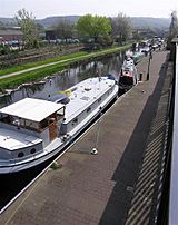
The broad canal is used much more since the Huddersfield Narrow Canal reopened in 2001. It is no longer a dead end. Instead, it is part of one of three routes that cross the Pennine mountains. This has led to better care of the canal and its locks. There is a pumpout machine at Aspley Basin that uses a card. Mooring spots have fresh water and electricity.
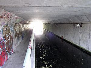
The Huddersfield Broad Canal originally connected to the Huddersfield Narrow Canal west of Wakefield Road (A629). After work to strengthen Wakefield Road, a new concrete tunnel was built under the old bridge. Now, boats wider than 7 feet (2.1 m) cannot use this short section. So, the Wakefield Road tunnel is now the effective end of the Huddersfield Broad Canal.
Canal Route Details
Just above Coopers Bridge, the Calder and Hebble canal enters a cut through a floodgate. The way to Ramsden's Canal follows the main river. It goes under the bridge that carries the A62 road. A large weir is straight ahead, protected by a barrier. The first lock is on the right, just above the weir. This lock is a Grade II listed structure. It dates from when the canal was built. A stone shows it was changed in 1899. The lock keeper's cottage next to it is also a listed building. It is made of stone and dates from the early or mid-1800s.
The canal then turns southwest and runs next to the River Colne. It goes under a railway bridge to reach Clone Bridge Lock. Just above this lock is an old stone warehouse from the 1700s. Then comes an arched bridge that carries Colne Bridge Road over the canal. A stone shows it was built in 1775.
Pipelines cross the canal at Colliery Bridge. After this is Ladgrave Lock, with a stone bridge over its end. The canal has industrial buildings on both sides as it reaches Longlands Lock. This lock also has a stone bridge over its end. The canal goes under an old railway bridge and the A62 road. It then passes near Deighton railway station. The A62 bridge is an angled bridge built when the canal opened. Parts of it are now covered by concrete additions for footpaths.
On the south side is a large playing field. The Inland Waterways Association held its big festival here in 2002. Turnpike Road Lock is at the south end of these fields. It has a separate overflow channel to the north. Reading Lock has another stone bridge over its end. Then comes Fieldhouse Lock and bridge, which carries Fieldhouse Lane over the lock end. Next is Falls Lock, and finally Red Doles Lock and bridge. This lock is 2.3 miles (3.7 km) from the start of the canal. The last mile (1.6 km) is flat.
The canal gets more surrounded by buildings. On the east side is Phoenix Mill, a five-story building with a slate roof. Near the North Eastern Gas Board offices, which are in a mid-1800s listed building, the canal makes a sharp turn under Leeds Road. On the west side is a tall, eight-sided chimney. It is over 100 feet (30 m) high and was built in 1872 for a cotton mill. Next to it is the Locomotive lift bridge. This bridge was put in place in 1865 and lifts straight up. It was fixed up in 2002 and now works with electricity. On the west side is a seven-story mill building. As the canal gets close to Aspley Basin, there is a canal warehouse on the west side. It dates from when the canal was built. Another warehouse, which is Grade II* listed, is just after Wakefield Road bridge. The basin itself is at a right angle to the canal.
Points of Interest
| Point | Coordinates (Links to map resources) |
OS Grid Ref | Notes |
|---|---|---|---|
| Cooper Bridge Lock | 53°40′53″N 1°44′06″W / 53.6814°N 1.7350°W | SE176205 | Jn with Calder and Hebble |
| Colne Bridge Lock | 53°40′44″N 1°44′01″W / 53.6789°N 1.7337°W | SE176203 | No 2 |
| Ladgrave Lock | 53°40′24″N 1°44′32″W / 53.6732°N 1.7421°W | SE171196 | No 3 |
| Longlands Lock | 53°40′11″N 1°44′40″W / 53.6696°N 1.7444°W | SE169192 | No 4 |
| Turnpike Lock | 53°40′01″N 1°45′21″W / 53.6670°N 1.7559°W | SE162189 | No 5 |
| Reading Lock | 53°39′57″N 1°45′36″W / 53.6657°N 1.7599°W | SE159188 | No 6 |
| Fieldhouse Green Lock | 53°39′49″N 1°45′50″W / 53.6636°N 1.7639°W | SE156185 | No 7 |
| Falls Lock | 53°39′47″N 1°45′56″W / 53.6630°N 1.7656°W | SE155185 | No 8 |
| Red Doles Lock | 53°39′40″N 1°46′15″W / 53.6611°N 1.7708°W | SE152183 | No 9 |
| Turnbridge Loco Lift Bridge | 53°38′52″N 1°46′31″W / 53.6478°N 1.7753°W | SE149168 | |
| Apsley Basin | 53°38′41″N 1°46′29″W / 53.6448°N 1.7748°W | SE149164 | Effective end of broad canal |
 | Aaron Henry |
 | T. R. M. Howard |
 | Jesse Jackson |


